Gov urges preparedness for thunderstorms
On Thursday evening, Governor Kathy Hochul issued a release about expected rainfall in the next few days.
“Nearly every region across the State will experience thunderstorms or heavy rainfall over the coming days, putting many communities at risk of isolated flash floods,” Hochul said in the release. “Localized flooding is possible in the New York City, Long Island, Mid-Hudson, and Southern Tier regions.
“Upstate regions including the Capital Region, North Country, Mohawk Valley, and Central New York are also at risk for excessive rainfall and isolated flash floods.”
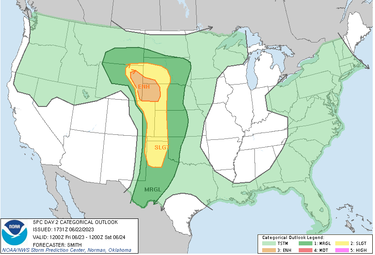
A Thursday National Weather Service map, forecasting weather for Friday, June 23, colors most of New York state as light green, meaning thunderstorms but not severe thunderstorms are expected. However, with that designation, the weather service notes that lightning and flooding threats exist with all thunderstorms.
The map for June 23 shows western New York along the Great Lakes and coastal New York state, including Long Island and New York City, colored a darker green like the rest of the East Coast, except in Maine.
The darker green indicates that isolated severe thunderstorms are possible. New York State is similarly colored for Saturday, with thunderstorms expected across the state and isolated severe storms possible along the Great Lakes and East Coast.
Areas slightly west of the center of the United states are colored yellow and orange, indicating scattered (yellow) or numerous (orange) severe thunderstorms are possible.
“State personnel are constantly monitoring forecasts,” the governor’s statement concludes, “and I encourage all New Yorkers to take responsible precautions: be aware of local forecasts, sign up for emergency alerts, monitor any road closures and prepare a bag of supplies in the unlikely event that a rapid evacuation is needed.”


