Earth quakes near Altamont
GUILDERLAND — Saturday evening, an earthquake occurred near Altamont.
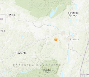
Two separate tremors were recorded five kilometers west southwest of the village, according to the United States Geological Survey website. The first occurred at 6:22 p.m. with a magnitude of 1.9 and a depth of 13.2 kilometers. The second occurred at 6:39 p.m. with a magnitude of 2.0 and a depth of 13.9 kilometers.
More than 50 small earthquakes have happened in and around Altamont since Jan. 1, 2000, according to a search on the USGS website.
Three decades ago, a seismograph machine was placed in the Helderbergs by the New York State Geological Survey to track tremors there — part of a network recording seismic activity in the northeastern United States and Canada.
Since the 1980s, there have been small earthquakes in the Helderbergs
“We feel the potential is there for an earthquake as large as [magnitude] 6,” Gary Nottis, a research assistant in seismology, told The Enterprise in 1991, when the seismograph was installed.
Nottis said the Thompsons Lake area had a series of small earthquakes and one, on Feb. 8, 1982, with a magnitude of 2.8, was not felt by anyone. It was preceded by several small earthquakes, called foreshocks, which typically occur days or hours before a larger quake. Aftershocks can occur for years after an earthquake.
Most earthquakes occur along edges of the Earth’s tectonic plates. Due to forces in the Earth’s molten interior, the tectonic plates move at a rate of up to four inches a year, traveling on a layer of softer rock called asthenosphere.
The plates separate or collide along their borders as they move, causing earthquakes and tremors. Even earthquakes many miles from a plate border can often be explained by the ripple effect of backup pressure caused by the collision.
A fault line runs from the Helderbergs to Lake George in the Adirondacks. An earthquake with a magnitude of 5.3 caused damage in Ausable Forks in 2002. On Oct. 7, 1983, an earthquake with a magnitude of 5.1 shook Newcomb in Essex County.
Both of those Adirondack earthquakes were in rural areas where no one was injured.
Scientists have developed two ways to measure the size of earthquakes — through magnitude and through maximum intensity. Magnitude is the most familiar measure, often expressed on the Richter scale.
Scientists measure the zig-zags on a seismograph and compare that with a standard reference for earthquakes. The resulting number expresses the strength of an earthquake at the place where it started. Each whole number expresses a 10-fold increase in ground motion.
Up to a magnitude of 2 is usually detected only by instruments; a magnitude of 3 can be felt indoors; M4 can be felt by most people and cause light damage; M5 can be felt by everyone and the damage is mild to moderate; M6 causes moderate to major damage; M7 causes major damage; and, with an M8 earthquake or greater, there is major destruction.
The San Francisco earthquake of 1906, probably the most vivid in American consciousness, had a magnitude of 8.3.
On June 17, 1991, Schoharie County had an earthquake with a magnitude of 4. In the 1870s and 1880s, there were two earthquakes in Schoharie County strong enough for people to feel.
The largest recorded earthquake in New York State was in Massena in St. Lawrence County on Sept. 5, 1944 with a magnitude of 6.
Roughly every 20 years, there is a damaging earthquake in New York State.