County redistricting commission resubmits final map to legislature
ALBANY COUNTY — The Albany County Redistricting Commission has submitted its second proposal to the legislature on the county’s new legislative boundaries, after its first plan was rejected in October for spreading minority voting power too thin.
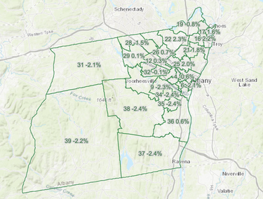
On Dec. 12, the commission sent over its final map and an accompanying report that lays out the changes made to each district, and the general reasoning behind the changes the commission made in this newest iteration, hoping that it will have sufficiently addressed the legislature’s concerns.
Majority Leader Dennis Feeney told The Enterprise he feels better about this map “because it creates five strong MMDs which was the issue with the last map.”
Chairman Andrew Joyce and Chairman of the Black Legislative Caucus William Clay — who, along with Feeney, had signed the legislature’s October letter to the commission explaining why the first map was rejected — could not immediately be reached for comment.
The legislature meets again on Dec. 19.
As The Enterprise reported last month, when the commission published its finalized majority-minority districts map, the legislature’s stated concerns — that by expanding the number and area of MMDs in the county, minority groups were at risk losing their voice in electoral politics — had been addressed, as the commission reverted that portion of the map back to what it more-or-less looked like for the past decade.
Districts in The Enterprise coverage area are modestly different from the map that was submitted in October, but significantly different compared to current district lines.
District 28, in Guilderland, which currently includes Hiawatha Trails Golf Course in the south, Pinehaven Country Club and much of the Pine Bush in its middle, Fort Hunter in the northwest, and extended east to the border of Guilderland and Colonie, would now shift north and east, losing everything west of Fusco Park and extend into Colonie, while running along Guilderland’s northern border at the top. The district is currently represented by Feeney.
District 29, also in Guilderland, would gain much of what District 28 loses, itself losing most of what lies between Guiderland’s northern border and West Old State Road. District 29 is represented by Mark Grimm.
Guilderland’s District 30, represented by Dustin Reidy, would lose Crossgates Mall and the areas south/southwest of it, while gaining areas north/northwest of Star Plaza and expanding a bit southwest of Waldens Pond.
Guilderland’s District 31, represented by Jeff Perlee, loses its portion of Berne but takes over all of Knox, where it currently represents just a portion. The commission, in its report, noted that state law requires that municipalities with populations under 40 percent of ideal district population — like Berne and Knox — should be kept whole, hence the change.
As a consequence of that change, District 39, represented by Chris Smith, would represent all of Berne, Rensselaerville, and Westerlo, plus a portion of New Scotland that now belongs to District 38.
Back in Guilderland, District 32, represented by Mickey Clearey, would gain the areas south of Crossgates Mall lost by District 30, while losing everything it has west of Normans Kill, and what falls between Waldens Pond and Dr. Shaw Road.
In New Scotland, District 33, represented by William Reinhardt, would gain areas around Stephen P. Wallace Park and the Colonie Country Club, as well as a significant area around the Albany Country Club, while losing the area around Orchard Street.
District 38, represented by Victoria Plotsky, would lose a chunk of New Scotland in its southwest (that which would be gained by District 39), the area around the Colonie Country Club, and, in the southeast, Spawn Hollow. It would gain the area around Orchard Street lost by District 33.
“We must reiterate,” the commission wrote in its report to the legislature, “that the number of large, undividable census blocks in many suburban areas not only contributes to oddly shaped borders in some districts but (when coupled with the recent State law tightening the allowable variation in population between LDs) has the unfortunate side-effect of forcing some district lines to be drawn right through older suburban communities whose much-smaller census blocks were the only way to meet those strict variation limits.
“By state law,” it said, “keeping LDs nearly equal in population has a much higher priority than keeping communities of interest together, and sometimes our district lines had to reflect that harsh reality.”


