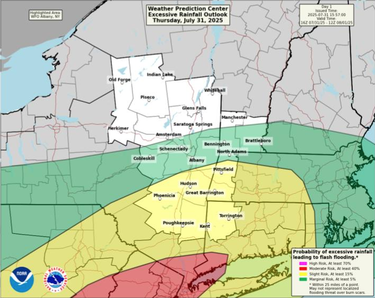
County at ‘marginal risk’ for flash floods tonight as emergency declared downstate
ALBANY COUNTY — Because of flash floods in the forecast, the governor has declared a state of emergency for 14 downstate counties and urges “all New Yorkers to stay vigilant, stay informed, and use caution as we expect excessive rainfall with the potential for flash flooding.”
Non-essential state workers from those counties were released from work at 1 p.m. today.
“State agencies,” Governor Kathy Hochul said in a release from her office, “are on standby for heavy downpours and localized flooding and will be monitoring the situation in real-time to ensure the safety of all New Yorkers in the path of the storm.”
There continues to be a low chance of isolated flash flooding for areas south and east of Albany this evening, according to the National Weather Service.
In Albany County, rainfall amounts of one to two inches are expected with a low chance for locally higher amounts over four inches. The threat for heavy rainfall is expected to end by midnight.
Explaining the cause of the heavy rains, the weather service says, “Satellite imagery shows two sources of rich moisture streaming into the Northeast with one plume stemming from the eastern Pacific and a second plume from the Southeast impinging into the mid-Atlanitc/southern New England.
“Where these two sources converge will be the focus for the heaviest rainfall rates and flash flooding concerns and latest high res guidance points to areas mainly south of our area” in the New Jersey-New York City metro which remain in the warm sector and have higher available instability, the service says.
The weather service makes this forecast: “A stretch of dry and seasonably cool weather ensues tomorrow through Saturday as Canadian high pressure builds over the Northeast supporting low humidity with abundant sunshine on Saturday.
“Friday night and Saturday night temperatures will be cooler than normal falling into the 40s and 50s thanks to ideal radiational cooling. We trend warmer Sunday through the middle of next week with daytime highs back in the 70s and 80s and higher humidity returning.”
The governor’s office urges residents to monitor their local forecasts, weather watches and warnings. For a complete listing of weather alerts, visit the National Weather Service website at alerts.weather.gov.
— Melissa Hale-Spencer


