NYS publishes household-level internet access map
— Map from New York State
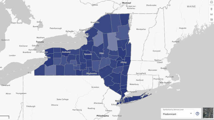
An overview of the new map published by New York State that offers address-level data on internet access.
ALBANY COUNTY — New York State has taken a big step forward in addressing internet availability for its residents by publishing a new household-level map.
For the first time, anyone anywhere can see which individual households in the state have internet access and which don’t, solving a problem where — in maps that surveyed internet access by census block — unserved homes would be unfairly grouped with the served homes around them and designated as such, rendering them all but invisible to those who have the power to provide the access they need.
At a glance, the new map shows how badly others have failed.
Because the served/unserved designation depends on whether a simple majority of homes within a census block have service, half of a municipality could theoretically be without service, yet be seen as 100-percent served. This would put it at a lower tier than an area that has whole blocks that are considered unserved.
That’s obviously useful to a point, but census blocks aim to contain at least around 250 households. In a small town that has about 1,000 households, there would theoretically be only four census blocks through which to determine funding priority.
Beyond that, such a town would need many of its residents to come forward to complain about their internet, or the town would need to spend lots of money (or find another entity that’s willing to) to come up with a more specific map — like the one that’s just been provided for free.
The new map, in addition to showing individual homes, also comes with a clustering feature, so it’s possible to survey the state of internet access on different levels.
What becomes clear is that, although there may be several different underserved clusters that are near each other (with anywhere from two to 100-plus households each, depending on the density of the area you look at), they’ll often be surrounded by just as many or more served clusters, further demonstrating how important the address-level representation of this information is.
It should be pointed out that the map does not account for fluctuations in day-to-day internet service that may afflict a user, such as dropping speeds (or dropped connections) that render service useless until the problem — whatever it might be — is resolved. So, some households that are frustrated by their internet quality may still find themselves inappropriately designated, though it’s difficult to know how prominent this phenomenon might be.
The criteria for served, according to the state, is that internet service can be provided by at least two companies and that one of them can provide high-speed internet, being that which reaches 100 megabits per second for uploads and 10 Mbps for downloads. But actual speeds can vary from advertised speeds for any number of reasons.
As far as the big-picture goes, the map itself likely doesn’t provide much new understanding for those within underserved areas and anyone with access to privately developed maps. Most know or could guess that the rural Hilltowns have a more serious internet problem than Guilderland.
But perhaps the map will allow — for instance — those who live on Bozenkill Road, in Knox, near where it intersects with Willow Lane, to see that they’re part of a small, specific community of unserved homes that’s surrounded by served homes, so residents could band together to take the issue up with authority, rather than feel powerless as a small part of a more nebulous group.
ConnectALL program
The map was published by the New York State Public Service Commission as part of the state’s new $1 billion ConnectALL Initiative, which was unveiled in January. As the name indicates, ConnectALL aims to tackle different aspects of what’s known as the “digital divide,” or the gap in quality-of-life that exists between someone with internet access and someone without.
For instance, ConnectALL has embarked on a marketing campaign to alert New Yorkers to the Federal Communications Commission’s $30-per-month financial aid program for those who can’t afford internet service at marketed prices. The state says that less than 30 percent of New Yorkers who are eligible have enrolled in the federal program so far.
ConnectALL also includes harder changes, such as removing fees for companies that are willing to build infrastructure in rural areas, which are typically the most underserved, and putting its own hardware into the “middle mile” segment of the infrastructure chain.
Along with the map, the commission published a report that gives a comprehensive overview of the state of internet access in New York, including historical efforts, contemporary county-level data, and so on.
Albany County overall is in good shape, the report says, with 98 percent of households considered served.
Starlink
Incidentally, Starlink — the arm of SpaceX that received billions of dollars in federal money to expand its satellite internet service and is seen by some as a saving grace in the time when state investments in broadband have yet to provide actual service to some residents — has also produced a map of its availability, and at a fairly local level.
SpaceX was founded by Elon Musk in 2002 with the goal of reducing the cost of space transportation so that Mars can be colonized. In 2015, Musk announced the development of Starlink, a satellite constellation, to provide broadband internet service.
The Starlink map shows service areas as big hexa gons over a map that doesn’t include municipal boundaries, making it difficult to determine exactly where it begins and ends, but it appears roughly available in Berne, Knox, Westerlo, and part of Rensselaerville and New Scotland, while unavailable in Guilderland and Voorheesville. The map indicates that the service will expand to those latter areas in 2023.
While the overall service map is imprecise, those interested can visit the Starlink website and put in their own address to check specific availability.
Some Hilltown residents have anecdotally reported during public meetings that SpaceX has worked for them, which contrasts a general (also anecdotal) dissatisfaction with other satellite internet companies, whose connections are thwarted by the severe topography of the Helderbergs as well as weather and other interferences.
The price of the service, however, has gone up over time, and is now $110 per month — to say nothing of the one-time cost of the hardware, which is $600, and then shipping on top of that.
Part of addressing the digital divide is addressing economics. Many families who are theoretically able to get internet access through a provider can’t afford the subscription fee, hence the FCC’s individual subsidy program. Starlink does not appear on the FCC’s list of eligible providers.