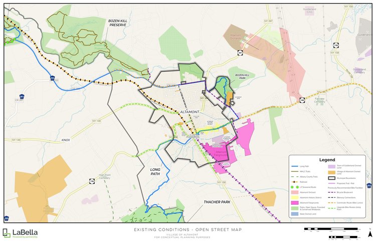
Historic Altamont maps an ‘emerald necklace’ of trails around the village, but Gun Club Road is a missing link
— From Historic Altamont trails master plan
The not-for-profit organization Historic Altamont has made a master plan to create trails or to connect to existing trails around the village.
ALTAMONT — The not-for-profit organization Historic Altamont has come up with a plan that envisions stitching together Altamont and Guilderland’s open spaces to form a “greenbelt” or “emerald necklace” around the village.
The network of conservation corridors would “act to buffer the well-known effects of suburban sprawl,” while linking into a single accessible system Thacher State Park, the Mohawk Hudson Land Conservancy’s Bozen Kill Preserve, the Black Creek Marsh Wildlife Management Area, Indian Ladder Farms, Tawasentha Park, and several other public and semi-public lands.
The plan doesn’t include cost estimates, timelines, or priority rankings of the eight proposed initiatives. It is a conceptual-stage document, designed to consolidate two decades of fragmented planning recommendations into a single reference for future grant applications and engineering work.
The plan, paid for with American Rescue Plan funds and prepared by LaBella Engineering, positions Altamont as a junction for three trail systems:
— The Long Path: A long-distance hiking trail that originates in Manhattan, runs through the Catskills, and is planned to continue through the Capital Region and on to the Adirondacks;
— The Helderberg Rail Trail corridor: Extending the existing Helderberg-Hudson Rail Trail from the city of Albany through the village of Voorheesville and into Guilderland; and
— The ring of public preserves and natural areas surrounding the village mentioned above.
During the March meeting of the Altamont Board of Trustees, one of the plan’s eight initiatives was discussed.
Mayor Kerry Dineen on March 3 expressed the village’s general support for the plan and sidewalk in particular, but was also clear there were limitations to that support, specifically the trail plan’s proposal to install a sidewalk along Gun Club Road connecting Main Street to Bozenkill Park.
Sidewalk for Gun Club Road
“It’s not our road,” the mayor said.
Gun Club, Dineen explained, is under the town of Guilderland’s jurisdiction. She also noted that, while there have been multiple unsuccessful attempts to obtain grant funding for the sidewalk installation, the village had backed the town’s efforts, typically with letters of support.
Trustee Nicholas Fahrenkopf said, whenever he or his fellow board members have met with the town, a Gun Club Road sidewalk is consistently one of the top two priorities raised.
Historic Altamont Vice President Debra Barnes Breitenbach told board members that, when she met with regional planners, she was told that the village and town are seen as relatively affluent communities, placing them lower on funding priority lists compared to municipalities like Cohoes.
Barnes Breitenbach was told that pairing a Gun Club Road proposal with other projects “would be helpful … They [said] a traffic study might be an initial step, and they could assist with that.”
Guilderland Supervisor Peter Barber told The Enterprise on Tuesday that the town applies for grants every year.
“We have received some grants over the years for sidewalks on Route 20, 146,” which are both state roads.
Barber said of a town road like Gun Club, “Getting sidewalk grants on town roads is a bit more problematic because, usually by their definition, they are not as heavily traveled as state roads are.”
Speaking specifically to Gun Club Road, Barber said, like many roads in that area, it is a “farm road or farm lane” that dates back to “probably the 1700s, maybe even earlier,” and when “the town comes along centuries later and wants to dedicate it as a town road, it ends up being a road that doesn’t have a right-of-way.”
On Gun Club Road, Barber said, there are stretches where there’s no right-of-way at all. “Sometimes the right-of-way is on the right-hand side of the road, and sometimes the right-of-way is on the left-hand side of the road.”
The reason a right-of-way is so important, Barber said, “is because that is where you put your sidewalk.”
Barber went on, “It gets very difficult, both in terms of design and in terms of just laying it out, because when you have a right-of-way acquisition where you have no right-of-way on one side of the road and that is the side where you are going to put your sidewalk, you have to get cooperation from owners, and oftentimes you have to pay tens of thousands of dollars.”
Bringing his explanation back to the difficulty of getting state money for town-owned infrastructure, Barber said the sidewalk on West Old State Road is one of the few for which the town has been successful in obtaining funds, likely “because it ties into a sidewalk that leads to Lynnwood Elementary School.”
For Gun Club Road, Barber said, “We have been trying to promote the fact that it goes to a village park in Bozenkill, but for whatever reason, it doesn't rate enough to get the funding that we have been requesting.”
Barber said another reason he thought the town hadn’t been successful in obtaining sidewalk grant funding for Gun Club “could be that the usage on Gun Club Road itself — even though it’s very important for residents on that road — has a relatively modest population compared to other roads.”
For example, Barber said, the sidewalk on Old State Road has “literally hundreds of homes that would reach that sidewalk and be able to reach the elementary school.”
Eight initiatives
The core of the Altamont Trails Master Plan consists of eight proposed projects:
— The Altamont fairgrounds to Orsini Park
At about 770 feet, the idea is to “create a connection between the Altamont Fairgrounds and the Altamont Central Business District including Orsini Park and the community kiosk. This connection could be a future part of the Long Path and could also link to a trail that encircles the village”;
— The Altamont fairgrounds to Bozenkill Park via Gun Club Road
At 4,790 feet, this proposal connects the 70-plus acre Altamont fairgrounds to the 32-acre Bozenkill Park
The plan noted that multiple planning studies have supported this goal: The Guilderland Bicycle and Pedestrian Connectivity Study from 2020; the Altamont Pedestrian and Bicycle Master Plan from 2009; and the Guilderland Pathways Master Plan from 2005 each recommend improved pedestrian and bicycle linkages between the two sites;
— A Long Path extension from Thacher Park to Orsini Park
“The Long Path is completed from Thacher Park to Leesome Lane, which was considered Phase 1,” the plan states. “Phase 2 is completing the trail from Leesome Lane to Orsini Park. Currently, there is a work-around with blazes by road for 1.25 miles down Leesome Lane to Rt. 156, down Helderberg Avenue and to Orsini Park. Discussions continue with private land owners for off-road routes into the village”;
— Bozenkill Park to the Bozen Kill Preserve
This proposal envisions what the plan calls the “Helderberg Greenway” wrapping around the village, connecting the park to the preserve. The route is approximately 1.5 miles, and would coincide with extending the Long Path to the village’s northwest side;
— The Guilderland Center Connection Trail
“No trail system currently exists linking the Village of Altamont to neighboring Guilderland Center,” the plan states.
At 3.17 miles, the plan connects the village to Guilderland Center via the two municipalities water-security discussion, suggesting a concurrent easement for the backup water-line extension and a public trail along Route 146.
“As stated in the recently published Guilderland 2025 Comprehensive Plan, the town supports efforts to implement an interconnection,” the trail plan states;
— Voorheesville to Altamont Rail-with-Trail
The 6.3 mile “rail-with-trail” is “an extension of the Helderberg-Hudson Rail Trail from Voorheesville to the Village of Altamont immediately adjacent to the Altamont Fairgrounds.”
The plan states the “project could preserve a large parcel” south of the village, “large acreage of densely wooded property [that] ascends the Helderberg Escarpment up to Thacher State Park and would provide a desirable expansion of the park”;
— The Black Creek Marsh Connector
The New York State Department of Environmental Conservation, the plan states, “maintains four trailheads and a small amount of trail through the marsh, but it is not well known to the public.”
The plan posits identifying potential routes from the existing DEC trails to connect to the village, and says there’s an opportunity to also link with the Indian Ladder Farms trail system as well as the proposed Voorheesville to Altamont rail-with-trail connection.
— Altamont Village Loop
“The new Long Path route created a ‘horseshoe’ around the Village of Altamont,” the plan states. “Starting near High Point, it loops around the village and then heads west. The Bozen Kill Creek corridor is a potential off-road route for the Long Path. This project would be to close the loop with a connector trail to the west of Altamont. This north-south route would roughly connect Thacher Park to the Bozen Kill Preserve.”