— Photo by Art Palmer
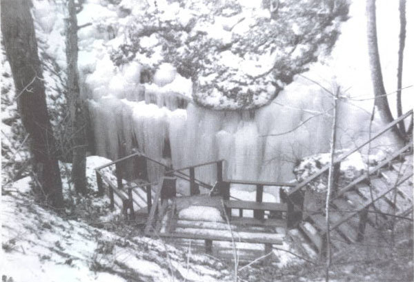
Knox Cave in winter has massive ice deposits cloaking its entrance. The photo was taken around 1960 when the staircase was still intact, but the scene looks much the same in any Helderberg winter.
— Photo by Mike Nardacci
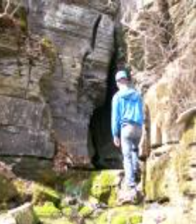
The picturesque entrance to Spider Cave gives no hint of its uninviting interior though its name alludes to the creatures that populate its walls in great numbers.
The precise locations of the caves referred to in this column have been left deliberately vague to protect both the caves and inexperienced persons who might wish to enter them. Those interested in local cave exploration are urged to check out the website of the Northeast Cave Conservancy — www.necaveconservancy.org — and to consider a cave trip tailored to their abilities during the period between May 1 and Sept. 30 when the caves are open for visitors.
One might — in a whimsical moment — regard it as “The Spelean Archipelago.”
Though sport- and scientific-cavers have long frowned upon the term “spelunker,” the noun “speleology” — the scientific name for the study of caves, derived from “spelaion,” the Greek word for a cave — and the adjective “speleological” have long become standard usage.
Across the northeastern United States, preserves in karst areas dot the map, ranging in size from a single acre to hundreds — “karst” being the term for a region of limestone or marble bedrock containing caves. They are owned and/or managed by two organizations known as the Northeast Cave Conservancy, which recently celebrated its 40th anniversary, and the National Speleological Society — commonly referred to respectively as “the NCC” and “the NSS.”
The preserves protect numerous caves, the watersheds they involve, the unique life within them, and the classic karst surface features such as sinkholes, disappearing streams, and springs. Many local cavers are members of both organizations, the websites of which detail the history and geology of the various preserves.
From May through September, the NCC also offers instructions on access to the caves for the qualified public. From Oct. 1 to the end of April, many Northeastern caves — and all of those under the ownership or management of the NCC and NSS — are closed to protect the caves’ bat populations, which in recent years have been ravaged by the insidious disease known as “White Nose Syndrome,” or “WNS.”
Commercial caves such as Howe Caverns and a number of privately-owned caves that do not harbor bats remain open; however, winter has never been a very popular time for sport caving except for the most dedicated cavers, given the fact that Northeast caves are almost by definition very wet, and slogging through snow in sub-freezing temperatures to and from the caves can be extraordinarily miserable.
The National Speleological Society was founded in 1941 by a small but dedicated group of cave explorers and since has grown to become an international organization with thousands of members. In the Northeast, the NSS owns three Schoharie County cave preserves: Schoharie Caverns, the Gage Preserve, and McFails Cave, the most extensive in the Northeast. All three properties were donated to the NSS by generous patrons and have been maintained over the years by dedicated volunteers.
Knox Cave tragedy leads to stewardship
Yet the NCC was born as the final result of a tragic winter caving accident in 1975.
In March of that year, several students from the State University of New York Outing Club were attempting to enter Knox Cave through its ice-encrusted sinkhole.
The cave near the hamlet of Knox had sporadically been run as a commercial operation like Howe and Secret Caverns in Cobleskill, most famously under the ownership of Delevan C. Robinson and his wife, Ada. In the mid-20th Century, the couple were responsible for the building of an elaborate staircase offering access to the cave, which lies over 100 feet underground, and for constructing walkways and installing lighting for tourists.
D.C. seems to have had what the Irish call “the gift of blarney,” and some of his descriptions of the cave and its extent were — to put it gently — fanciful. But the cave features both large, easily-accessed passageways and more challenging sections that require stamina and sometimes ropework of explorers, and it has attracted serious cavers for many generations as well as tourists during the relatively brief periods when it was commercialized.
The Robinsons also built a large roller rink adjacent to the cave’s entrance sinkhole, which for a while in the 1940s and 1950s was the scene of skating parties and country dances. It seems to have formed a center of social life for the Hilltowns in the days when not many hardworking Helderberg folks could afford the time or the money to travel to nearby cities for entertainment.
But following D.C.’s death in 1961, commercial operation of the cave ended for the last time though sport cavers and scientists continued to gain access to Knox Cave with the kind permission of D.C.’s widow until she died in 1964.
Some time in the mid-1960s, the largely abandoned property was purchased by a Long Island corporation called “Organa Industries,” which announced its intention to restore the cave and dig out a boulder-choked sinkhole adjacent to its classic entrance to allow a through trip. But Organa Industries went belly-up and the restorations never took place.
Old-timers in the Knox area may remember the huge steam shovel that stood for years in the field next to the commercial entrance but it seems never to have been employed in digging the clogged sinkhole and it eventually collapsed into a rusty pile of warped metal and cables.
The result was that access to Knox Cave was without any sort of control; in the years that followed, the staircase and the walkways deteriorated and the lighting system and many of the cave’s natural decorations were vandalized and the skating rink and the Robinsons’ 200-year-old farmhouse were torched.
Even the massive frozen waterfalls that formed in winter from drainage in the fields around the Knox sinkhole did not deter visitors from entering the cave. Sometimes the warmer (48-degree) air within the cave would melt a tight hole allowing access to the adventurous — or risk-takers — while at other times the even more foolhardy were rumored to be using sledge hammers to smash their way through the ice to gain entrance.
In any case, one day in March, 1975, although snow still covered the ground, the temperature rose to 50 degrees as a group of students from SUNY Albany tried to enter the cave. Runoff from the melting snow poured in a cascade behind the ice deposits and the result was that a massive block of ice broke away and came crashing down, killing one student and leaving another paralyzed from the neck down.
By that time, the cave and surrounding land had been sold for non-payment of taxes to a doctor from Schenectady. Fearing additional injuries and lawsuits, the doctor attempted to donate the cave to the National Speleological Society.
But the same fears caused the NSS to reject the offer and a group of cavers became concerned that the cave might be acquired by someone who would ban all exploration or even bulldoze its entrance sinkhole, effectively closing it permanently.
Thus, in 1978, three area men — Dr. Art Palmer, Robert Addis, and Jim Harbison — formed the Northeast Cave Conservancy as a not-for-profit corporation and Knox Cave has continued to be made available to qualified cavers. Over the years, subsequent exploration has added close to 1,000 feet of previously unknown passage to the map of Knox Cave and revealed another segment of passage yet to be connected to Knox known as Crossbones Cave.
And over the years, through purchase or donation, the Northeast Cave Conservancy has acquired a number of other parcels of land containing caves that are also well-known to explorers.
Caves galore
A western portion of the Helderberg Plateau known as Barton Hill in Schoharie County rises steeply above the Fox and Schoharie creeks. A standing joke among cavers is that the hill is hollow because of the numerous caves that underlie it.
One large parcel of land owned by the NSS was donated by long-time caver and local attorney Jim Gage and contains Schoharie Caverns, which resembles a slot canyon; its entrance lies at the base of a limestone cliff on the edge of the plateau.
Schoharie Caverns consists of nearly half-a-mile of streamway featuring beautiful stalactites and stalagmites, which decades of visits by college outing clubs and other groups have left marvelously intact. A spartan cabin on the parcel is maintained by local cavers and is available for groups visiting Schoharie Caverns and other nearby cave preserves.
And there are many. The NSS also owns another large parcel of land on Barton Hill donated by Jim Gage and named in his honor; it contains Ball’s Cave, named after its 19th-Century landowner. Its vertical entrance lies in a heavily-wooded section of the hill and has drawn visitors for over 150 years.
The cave features immense rooms as well as low crawl ways, and a diminutive flooded segment of the cave known as the “Lost Passage” requires cavers to experience an “ear dip” to pass through it. (Do you really want to ask?)
Although there are a number of other known or suspected caves on Barton Hill not under the control of the NSS or NCC, Spider Cave was recently donated to the NCC by a local landowner. ts alluring entrance has been described as “Storybook,” but explorers have found that it is a very short story except for those intrepid enough to challenge its agonizingly tight, wet main passage that extends for over 1,000 miserable feet into the plateau. And those who enter its easily accessible first hundred-or-so feet will encounter hundreds of its eponymous creepy occupants scampering across the cave’s water-smoothed walls.
McFails is the jewel
Generally considered the “jewel in the crown” of northeast caves is McFails Cave on the Cobleskill Plateau. Its entrance is in a beautiful hemlock and hardwood forest pockmarked with gaping vertical sinkholes, some of which take voluminous quantities of water from time to time.
Only a short and very unpleasant segment of McFails was known until 1961 when some students from Cornell University plunged through a pool with just a few inches of airspace and discovered that the cave did not end at the uninviting pool.
Today the cave is known to be over seven miles in length, much of which consists of high canyons and large chambers beautifully decorated with calcite formations. But the cave can be treacherous: Entrance requires rappelling down seventy feet — in wet weather through a waterfall — and much of a cave trip involves constant immersion in a cold stream, making the wearing of a wetsuit a necessity.
The cave has been hydrologically connected to other caves on the plateau, meaning that water in them them has been traced to McFails. Thus the potential exists for a cave system some 26 miles in length — a fact likely to draw intrepid explorers for years to come.
Clarksville Cave is the best known
Undoubtedly the NCC-owned cave that is best known to the general public is Clarksville Cave, which has drawn visitors for well over 150 years. Groups from camps, schools, churches, and colleges regularly visit the cave between May 1 and Sept. 30.
Clarksville has three known entrances and lies beneath a hardwood forest laced with nature trails. While much of the cave consists of subway-tunnel size passages, more adventurous visitors are drawn to its tight — and wet — challenging sections that lead to pools and a picturesque waterfall.
Despite its easy accessibility and heavy traffic in summer months, much of the cave is relatively pristine and its numerous classic features both above and below ground make it a veritable textbook example of cave and karst geology.
Ominous Onesquethaw
Not far from the village of Clarksville is the lesser-known Onesquethaw Cave also owned by the NCC. Named for the stream that flows through the valley in which its entrance lies, its low, twisting passages are studded with fossils and its sometimes maze-like layout gives the cave a certain allure.
But Onesquethaw is not for the novice cave explorer and has long had a somewhat ominous reputation. It lies in a low area that is prone to flooding and in times of sudden heavy precipitation a roaring stream enters the cave and can fill its passages to the ceiling.
In 1991, a group of students from Syracuse University became briefly trapped in Onesquethaw when a torrential surge of water flooded the cave, setting off a massive rescue effort that drew news organizations and cave-rescue teams from all over the Northeast. The students had fortunately found a room with a high ceiling and were able to cling to the walls until the water levels finally dropped and allowed them to leave the cave.
As the students’ experience in Onesquethaw Cave demonstrates, the subterranean world demands respect of those who enter it. The Northeast Cave Conservancy and the National Speleological Society have not only managed to acquire and keep open many classic Northeastern caves for qualified visitors, they have educational and scientific components as well.
Through work with the general public as well as scientists and qualified students, ranging from grade school right up through university-level students, the organizations have helped to maintain and protect the resources of the world beneath our feet.
And the NCC and NSS are not alone. All across the 48 contiguous states and in Hawaii many hundreds of acres of karst lands and areas underlain by lava caves have been acquired and protected by organizations of dedicated cavers: a “spelean archipelago” indeed.
Could statehood be far behind?
Location:

— Photo by Mike Nardacci
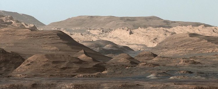
Heavily eroded petrified dunes in the Bisti wilderness show cross bedding. Almost identical features have been found in Gale Crater on Mars.
— Photo by Mike Nardacci
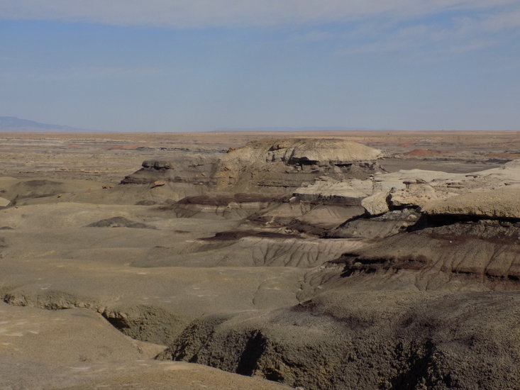
These mudstone and sandstone hills in the Bisti wilderness exhibit layers colored by various minerals deposited in an ancient inland sea.
— Photo by Mike Nardacci
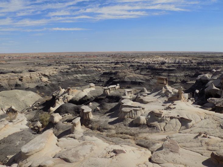
A maze of weirdly-shaped hoodoos were created by the erosion of rock layers with varying resistance to the actions of wind, running water, and frost.
— Photo by Mike Nardacci
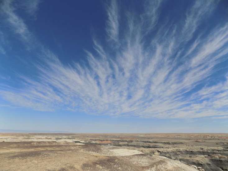
Cirrus clouds made of ice crystals waft high in the atmosphere above the Bisti wilderness. Similar clouds have been photographed on Mars by the Curiosity rover.
— Photo by Mike Nardacci
Rounded hills in Gale Crater on Mars are made of sediments similar to those in the bedrock of the Bisti/De-Na-Zin wilderness.
The Bisti/De-Na-Zin wilderness in the northwest corner of New Mexico is hot and dry for much of the year — when it is not bitter cold and dry — and it is far from the regions that are well-known to tourists such as those surrounding the cities of Santa Fe, Albuquerque, and Taos.
Even some of the draws for the more adventurous visitor — the “Sky City” Pueblo called Acoma, the stunning ancient Anasazi ruins of Chaco Canyon, and artist Georgia O’Keefe’s beloved Ghost Ranch — are far better known and more accessible than the Bisti/De-Na-Zin Badlands. Perhaps due to a recent article with photographs in “New Mexico” magazine, the public has become more widely aware of the preserve but the location’s remoteness virtually guarantees that even on weekends hikers are likely to find few others venturing into the barren wilderness.
The term “badlands” was coined by non-geologists but has been appropriated by geologists to describe an area featuring an exceedingly arid climate and relatively soft bedrock that has eroded into hills and sometimes weird sculptured shapes called “hoodoos.” Practically nothing can grow in badlands and even creatures such as insects, lizards, and snakes may be rare.
The Badlands of South Dakota became a national park because of the particularly colorful strata — layers — found there but large stretches of the United States Southwest and many other places scattered across Earth’s surface are badlands in fact if not always in name.
Geologists have always had great interest in badlands because in such barren landscapes — unlike in the well-watered, forest-and-field-covered stretches of the Northeast — the underlying bedrock lies open to easy viewing, and, where wind, ice, and water have worked on the bedrock, researchers can see deeply into the strata to find hidden clues to ancient environments.
The Bisti/De-Na-Zin badlands lie southeast of Farmington, New Mexico. The words are Navajo; “Bisti” translates to something like “large area of shale hills,” which perfectly describes it. “De Na Zin” references falcons, seen occasionally in the wilderness area.
Its soft bedrock is mainly shale and mudstone interspersed with volcanic dust dating from the Cenozoic Era, the age of the dinosaurs. Its eroding hills and hoodoos have yielded numerous fossils of dinosaurs and other creatures that were their contemporaries as well as plants.
The strata that make up the bedrock contain varying amounts of minerals such as iron, carbon, magnesium, and quartz, which give them different colors: black, white, gray, purple, brown, and in some striking examples, bright rusty red. The strata were laid down in what in ancient times was a delta on the edge of the long-vanished Western Interior Seaway and the purple layers get their color from iron dissolved in the water.
While most of the brown strata are mudstone, the black strata are either shale containing decayed organic matter or soft coal; at some point in ancient times, the coal caught fire, possibly due to nearby volcanic activity. In any case, there is evidence that the fires burned underground for centuries, leaving behind a brilliantly red layer that erodes into piles of rust-colored sand and what appear to be crushed bricks.
An adventure
With some friends, I set off on a hike into the Bisti/De-Na-Zin badlands on a warm day in early June. Hikers are advised to carry a device with GPS or a compass as the preserve does not have marked trails and landmarks can be deceiving, but we did observe a line of abandoned telephone poles that ran close to the primitive parking area.
Fortunately, given the gentleness of the topography, the poles were visible from great distances, providing us with easily visible reference points as the mazes of gullies and hoodoos of Bisti would not be good places in which to lose one’s way.
We set off over a series of low hills made of crumbling soft coal — a lifeless wasteland that looked like a landscape of Mordor in Tolkien’s Lord of the Rings — an uninviting beginning to a hike that gave no clue to what lay beyond.
Soon we climbed up out of the coal-bearing strata and found ourselves among the eroded fragments of ancient sand dunes, showing characteristic structures called “cross-bedding,” evidence of deposits caused by shifting water currents. In such locations, paleontologists sometimes find the footprints of late-Mesozoic dinosaurs.
Our map showed a great cluster of hoodoos half a mile or so away and we set off in a southerly direction. Soon we came upon a series of garishly-striped hills into which were eroded steep, narrow gullies — miniature slot canyons formed by the region’s occasional but torrential floods. On higher ground now, we could look across a wide, broad valley into which the sediments eroded off the Bisti hills have been settling for millions of years.
There were domes and small mesas, wide arroyos and narrow gullies, towering hoodoos, balancing rocks, and small erosive features resembling tables, turtles, barstools, and weirdly organic-looking forms suggestive of creatures out of some scary fairytale.
We climbed to a vantage point, a low flat-topped hill from which we could look down into a bewildering maze in which many of these sculpted features were clustered together. Nearby, and scattered randomly, projecting from the baked ground beneath our feet were fossilized stumps of Mesozoic-age trees that might once have offered shade to a dinosaur.
Though the air temperature was only in the low 80s, the sun overhead shone out of a sky swept with high, feathery cirrus clouds; the air was clear but for the thin haze caused by one of the Southwest’s forest fires that have been frequent this year. Though the scene before us was not without a stark beauty, it also seemed absolutely barren of life — and yet, from time to time a dusty-colored lizard would scamper across our paths and there were a few parched-looking cactuses and other desert plants.
The Bisti wilderness is also home to a number of golden eagles, hawks, and falcons but the occasional birds we could see soaring on updrafts above the baking ground were too far away for identification. In Jeff Goldblum’s iconic phrase from Jurassic Park — “Life will find a way.”
Like Mars
Some photographs sent back recently by the National Aeronautics and Space Administration’s “Curiosity” rover, which is currently climbing through the terrain of Gale Crater near the equator of Mars have demonstrated that the Red Planet, too, has its badlands.
The first blurry photographs of Mars returned by the Mariner 4 spacecraft in 1965 appeared to show what Carl Sagan called “a dull, uninteresting landscape” — all sand dunes and flat deserts like “Tatooine” in the “Star Wars” films, but subsequent probes showed that by very bad luck Mariner had missed vast stretches of Mars with complex, fascinating landscapes, including a spectacular canyon seven times deeper and 10 times longer than our own Grand Canyon.
In addition, photos of dried stream beds and river channels hundreds of miles long proved that the planet once had enormous amounts of flowing water — an absolute necessity for life as we know it.
Gale Crater was created eons ago when an asteroid crashed into the surface and the subsequent rebound of the bedrock thrust up an enormous peak called Mount Sharpe. The Curiosity rover began exploring the crater in 2011 and early on in its mission it sent back a photograph of the upthrust bedrock that shows a startling resemblance to some of the layered, eroded hills of the Bisti badlands.
The hills in Gale Crater have been found to be made of bedrock resembling shales and sandstones, interspersed with layers of volcanic dust — very similar to those in the Bisti wilderness and providing clues to the ancient environment of Mars. Cruising around the floor of the ancient crater, Curiosity has also analyzed numbers of heavily eroded hoodoos composed of cross-bedded sandstone.
These are evidence that the great crater was once filled with salty water with shifting currents that deposited the sand that was later turned to stone. Elsewhere the rover has photographed channels filled with rounded pebbles, the beds of ancient streams that flowed across the surface.
Today the Martian atmosphere is far too thin and cold to allow liquid water to remain on the surface for long without evaporating or freezing. But just as the hills of badlands such as Bisti/De-Na-Zin give scientists clues to the ancient environments of Earth, the eerily similar hills of Gale Crater give insight into the ancient past of Mars, and what they show is far different from what was inferred in the 1960s from those first, blurry images of the Martian surface.
The planet’s landscape is anything but “dull and uninteresting” and evidence shows that in the distant past, Mars was a warmer, wetter world with a thick atmosphere, and featured extensive bodies of salty water as well as rivers. In such a world life could have flourished.
But the surface today is devoid of anything living, subjected endlessly to ultraviolet radiation from the sun because of Mars’s thin atmosphere, and not a blade of desert grass nor dusty, stunted shrub is visible in the blasted landscape.
Eerily, the thin clouds that appear in Curiosity’s photographs are almost identical to those above the Bisti/De-Na-Zin wilderness: wispy feathery cirrus clouds formed from crystals of water ice high in the Martian atmosphere.
But, unlike the milky blue sky above New Mexico, the sky on Mars is a dusty yellow from tiny dust particles suspended in the atmosphere high above the surface by the planet’s winds. Sampling that atmosphere, Curiosity not long ago made a tantalizing detection: The cyclical presence in the atmosphere of quantities of methane.
The colorless, odorless gas is easily destroyed by ultraviolet light, and the atmosphere of Mars today is far too thin to prevent its destruction, meaning that the gas must constantly be replaced. While methane can be emitted during volcanic activity, the giant shield volcanoes on Mars appear to have been inactive for millions of years.
But methane is also a common waste product of biologic activity. Curiosity has found that in the relatively warmer months in Gale Crater the amount of methane increases and then levels off and falls as the climate gets colder. The possibility that this could be indicative of the activity of sub-surface primitive organisms has thus arisen.
Though relatively benign by comparison, the harsh climate of the Bisti/De-Na-Zin wilderness supports the existence of a few hardy forms of plants and animals, while the environment of Mars today is hostile in the extreme to living things. The thin air contains almost no oxygen and the dry, bitterly cold, barren landscape is constantly blasted by lethal radiation from the sun.
But the fact that Mars in distant ages was apparently much friendlier to life — if life ever arose there — gives hope that a few hardy organisms might have found refuge in a warmer, wetter, protected environment underground. Life, after all, is well known for “finding a way.”
Location:
— Photo by Mike Nardacci
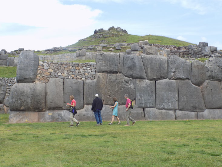
Massive, intricately-carved stone walls in the citadel of Sacsayhuaman dwarf visitors. Some of the boulders weigh upwards of 90 tons and their shapes are believed to make the walls resistant to earthquakes.

— Photo by Mike Nardacci
Terraces: The citadel of Ollantaytambo in the Sacred Valley of the Incas was the site of one of the few battles lost by the Conquistadors as they swept through the Incan empire.
— Photo by Mike Nardacci
A view from the train that transports visitors to Machu Picchu through the Sacred Valley shows the towering Andes peaks are covered in snowfields and glaciers; the melt-water eventually reaches the Amazon River.
— Photo by Mike Nardacci
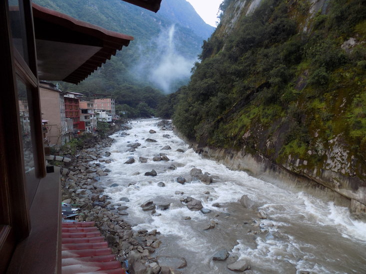
Rapids of the Vilcanota River flows through the village of Aguas Calientes. Downstream, it becomes known as the Urumbaba River and eventually is a tributary to the Amazon.
Is it possible that Number 5 could be printed larger than the others?
— Photo by Mike Nardacci
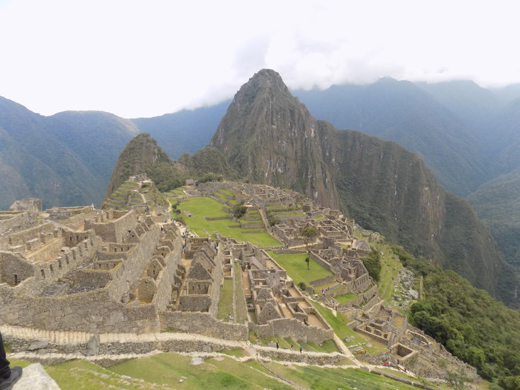
The classic view of the citadel of Machu Picchu, showing granite walls and terraces that sprawl beneath Pyramid Mountain on which a dizzying rail ascends to a Sun temple on the summit.

— Photo by Mike Nardacci
Mountains surround Machu Picchu and, from the deep valley of the Vilcanota River, mists rise, cloaking the site at times in a mystical aura.
The engineering achievements of the ancients astound us: The vast size and precision of the Egyptian pyramids, the extraordinary aqueducts of the Romans, the incredible invention of Greek temples such as the Parthenon, the environmental challenges overcome by the people of Southeast Asia to build the Great Wall in China and Angkor Wat in Cambodia, the extensive waterworks and massive temples of the Maya and the Aztecs — all continue to amaze and enthrall in spite of our own achievements using modern technology.
It is no wonder that some today deride the ancient people with assertions that they could not have achieved what they did without help from Out There and continue to claim evidence of extraterrestrial intervention from the star Sirius or some civilization with its home on one of the stars in the belt of Orion.
But a scientist friend of mine put the whole situation into perspective with this observation: “These so-called ‘researchers’ are telling us that beings with the technology to fly faster than light across the universe visited Earth in the distant past — and spent their time here showing ancient people how to cut and pile up rocks? After a journey like that, wouldn’t it have been more productive to teach our ancestors how to make penicillin? Or instruct them in the generation of electricity and the building of computers? Or show them something as simple but essential as the wheel, which many of them did not have?”
It is a fact that the ancient people had brains as big and complex as ours today and when they wanted to do something badly enough, they often figured out ingenious ways to do it without help from E.T. And we moderns frequently stand in absolute awe of what they accomplished using technology that we all too frequently brand “primitive.”
Early in April, I flew to Peru with friends to visit some of the major sites of the Incas. Since we had very limited time, we had booked one of those hectic if-it’s-Tuesday-this-must-be-Cusco vacations, the result being that the whole trip now seems like something I dreamed and I look upon the photos I took with that did-I-really-go-there sense of wonder and confusion.
Bu,t if the confusion is genuine, so is the wonder: at the incredible beauty of the Andes Mountains rising above lush but intimidating jungle; at the clash of the Incan and Spanish civilizations that gave birth to the mestizo (“mixed”) culture of modern Peru; and at the astounding architecture of the Incan peoples over 500 years ago that resulted in the construction of citadels such as Machu Picchu and other “lost” cities.
We began our trip with a very brief stay in Lima, Peru’s vibrant capital city, built atop thick layers of unconsolidated river sediments washed down from the Andes over millennia — the consequent instability of which makes the city a dangerous place to be during an earthquake: a subject, perhaps, of a future Back Roads Geology column.
Early on our second day there, we boarded a plane for a short flight to Cusco — also spelled “Cuzco”— an ancient center of the Incan Empire situated at an elevation of 10,000 feet in the Andes. Spanish conquerors did a rather thorough job of destroying the Incas’ “pagan” buildings but in many places the colonial-era palaces and churches they raised were situated on those buildings’ foundations.
Cusco is today a sprawling city, overflowing with tourists even in what is considered its low season — but their presence has ignited the city’s economy and much of the Old City is one immense traffic jam. Coupled with the elevation, the exhaust from motor vehicles makes breathing a challenge for those who have not acclimatized — which included many people such as ourselves who were there only briefly as Cusco is the jumping-off point for visitors bound for Machu Picchu.
The chewing of leaves from the coca plant is supposed to aid in alleviating the effects of altitude, and it seemed as if every hotel and restaurant offered patrons huge bowls of the dried leaves that they were encouraged to chew, or cups of tea made from coca leaves. I found the leaves to have a rather unpleasant flavor and, though the tea served with sugar was slightly more agreeable, any effect that the coca is alleged to have eluded me.
Sacsayhuaman
Much of our one full afternoon in Cusco was spent at the ruins of one of the citadels of the ancient Incan emperors called “Sacsayhuaman,” sprawled atop a flat hill high above the city. Our guide laughingly informed us that, although the name is almost unpronounceable to anyone not fluent in the Incan language — still spoken by many inhabitants of Peru—saying “sexy woman” gives a fair approximation.
Levity aside, even in ruins, the site inspires admiration for its builders. A stronghold of Pachacutec, one of the last of the Incan emperors, the site consists today of a series of formidable stone walls and terraces covering many acres, cut from the plateau’s limestone bedrock.
Though it is difficult to envision what it looked like in the days before it was largely leveled by the Spanish conquistadors, shaping and moving the massive carved boulders that make up the foundations and walls of the various structures would challenge 21st-Century engineers. Some of these limestone blocks weight upwards of ninety tons.
The awareness that the Incan builders accomplished this work with muscle power and simple tools alone astounds. Not only are the seams between the boulders tight enough that a knife blade cannot fit into them, the individual boulders themselves are often not cubic or rectangular.
Some of the huge blocks have slightly curved sides and, instead of having eight corners, may have as many as 14 or 16, showing that they were shaped with consummate skill. Current archaeological theory is that these intricate, tight-fitting shapes made the buildings resistant to earthquakes, a constant danger in Peru’s seismically-active landscape.
And indeed — in Lima and Cusco and other Peruvian cities, Colonial-era churches and palaces that were built on the foundations of razed Incan buildings have ridden out tremors with considerably less damage than structures around them lacking such foundations. Of course, millennia earlier, the ancient Egyptians also moved immense blocks and fitted them with uncanny precision, but the huge stones with which the Giza Pyramids were constructed are cubic or rectangular and have just eight corners.
Sadly, besides the massive walls and terraces, little else remains at Sacsayhuaman to testify to the extraordinary engineering skills of the Incas.
Sacred Valley of the Incas
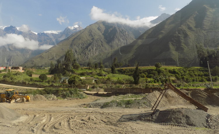
The next day, the sky was gray with low, scudding clouds, and early in the morning we embarked by van up over the mountains surrounding Cusco, headed for what is romantically named the Sacred Valley of the Incas.
Getting there first required a steep climb up narrow, twisting roads followed by a descent of several thousand feet, all the while passing through green, terraced fields in which men and women in traditional Andean dress labored among crops and herds of sheep and llamas — pronounced “yamas” in Peru.
Before starting the descent, we paused at an overlook that presented a heart-stopping view of the switchbacks plunging into the valley and our first look at the high Andes. As the sky was overcast, the view was sketchy — but far off through breaks in the clouds were glimpses of glaciers and jagged, snow-covered peaks rising out of the mists that hung on the precipitous green slopes: It seemed a vision of the Himalayas.
In the afternoon, we climbed the ruins of the enormous Inca citadel called Ollantaytambo, site of one of the few defeats suffered by the Spaniards as they fought their way through the Sacred Valley. Situated between two steep mountains, it consists of a residential area on the floor of the valley and a series of massive terraces like giant steps ascending one of the slopes, accessed only by two narrow stone staircases.
The terraces served both as gardens and fortifications, and atop the slope is a broad platform with a temple. It is not difficult to understand why the Spanish conquerors were unable to take the fortress: The defending Incas had gravity on their side and were able to rain down crushing boulders onto the invaders.
The platform sits atop precipitous cliffs dropping a hundred feet or more, and tightly fit into the tops of the cliffs are stone walls consisting of the characteristic enormous, meticulously-shaped boulders. Constructing the walls must have been a daunting challenge — one misstep on the part of the workers shaping and placing the boulders would have resulted in a deadly fall, undoubtedly accompanied by the thunderous collapse of sections of the wall as well.
Once again a visitor stands in awe of the Incas’ determination and skills.
Jungle journey
Early the next morning, we were deposited at the train station in the little town also called Ollantaytambo and we boarded the dome train that transports visitors through the jungles of the Sacred Valley to the village of Aguas Calientes, close to the citadel of Machu Picchu.
The 80-minute trip follows the ancient Inca Trail and the furiously-rushing Vilcanota River that downstream changes its name to the Urumbaba and eventually becomes a tributary to the Amazon.
The trip must be one of the most scenic train rides in the world. Heading toward Machu Picchu, on the right side of the cars passengers have a close-up view of the jungle which seems at any moment about to engulf the tracks.
It is a tangle of towering trees casting the floor into semi-darkness in which glimpses can be had of white, pink, and yellow orchids and other tropical flowers growing among shrubs and enormous ferns. But like giant entangling spider webs, vines thick and thin connect the trees and would make passage through the jungle a nightmare, even with machetes.
Occasionally visible through breaks in the foliage was the ancient Inca Trail that follows a narrow path through the jungle; it is a popular four-day hike for the adventurous visitor willing to challenge the biting insects and venomous snakes but in many places it was obvious that a hiker could be less than 50 feet from the train tracks or the trail itself and become hopelessly lost in the strangling vegetation.
Frequently there are foaming brooks and cascades pouring down from the high surrounding mountains, their waters bound for the Vilcanota and eventually joining the dark, meandering stretches of the Amazon.
And yet, despite the feeling generated of being in an endless, remote wilderness, periodically the train passes through areas on the far bank of the Vilcanota where archaeologists have cleared away the invading jungle and uncovered remote Inca settlements consisting of the characteristic terraces and foundations of dwellings, abandoned hundreds of years ago as the conquistadors marched ever deeper into the vastness of the Incan empire.
In other places, the jungle suddenly retreats and is replaced by a wide stretch of the valley floor that is being farmed or mined today by hardy descendants of the Incas; here the scene suddenly opens up to allow through the dome of the car breathtaking views of the high Andes: dark, craggy peaks in silhouette against the clouds or broad snowfields and glaciers gleaming in the brilliant sunlight, once more irresistibly evoking the landscapes of the Himalayas.
Ring of Fire
Shortly before noon, we arrived in the tiny picturesque village of Aguas Calientes — “hot waters” in translation. The village rises steeply above the eastern bank of the Vilcanota River, which descends energetically past the village in a series of roaring cascades and plunge pools.
A hot spring near the village has attracted bathers for hundreds of years. There are no volcanoes in the area, but the Andes Mountains rose — and continue to rise — as a result of the interaction of two of Earth’s major tectonic plates: the Nazca plate and the South American Plate, and the interface between them constitutes a section of the Pacific “Ring of Fire.”
The Nazca Plate takes up a large section of the Eastern Pacific Ocean and it is being pushed up against and subducting beneath the South American Plate; this causes the South American Plate to crumple, forming the Andes, but the friction caused by the subducting Nazca Plate melts parts of the crust and the molten rock rises to the surface and explodes in volcanoes. The presence of the hot springs in Aguas Calientes indicates the presence of molten rock not far beneath the surface.
In search of Vitcos
Immediately on leaving the train, we were escorted to a bus which takes visitors up a series of sharp and exposed switchbacks to the plateau on which Machu Picchu lies. It is a hair-raising ascent through the jungle with one 180-degree turn after another — and of course, there are no guard rails.
On some turns, passengers on one side of the bus or the other literally can see no road beneath them as they look out the windows but instead are staring straight down a plunge of hundreds of feet into the deep, rocky gorge of the Vilcanota River.
Along the way, the road frequently intersects one of several steep stone staircases that slice through the jungle and in ancient days offered the only access to Machu Picchu; these made the site virtually impregnable — even if the conquistadors had learned of its location — which they never did.
In fact, although rumors of its existence had been widespread for centuries, except for a few hardy farmers in the area, the rest of the world — including most Peruvians — remained unaware of its existence until 1911 when an expedition sponsored by Yale University and the National Geographic Society led by Hiram Bingham discovered it with the aid of some of those farmers.
Many explorers before him had been searching for the gold of the Incas that had not been appropriated by the conquistadors — and they had taken incredible amounts of the precious metal from Incan temples and shrines.
The interiors of the great cathedrals on the central squares of Cusco and Lima and other Peruvian cities are decorated with jaw-dropping quantities of gold, giving them a truly ethereal glow. But legends have persisted for hundreds of years that, as the Spanish conquerors swept through Peru, the forewarned Incas secreted much of their gold in places that have yet to be discovered — a powerful lure to adventurers even today.
However, Bingham and the Yale expedition were not looking for the vanished Incan gold: They were in search of Vitcos, the fortress that was considered to be the capital of the Incan empire.
Questioning occupants of one of the small villages scattered along the Vilcanota River, they learned that some of the farmers had been working ancient terraces on top of a nearby peak known as “Machu Picchu” — Incan for “old mountain.”
Machu Picchu
Ascending the peak by way of one of the ancient trails, Bingham and his crew came upon the hidden fortress. Though the jungle masked most of the magnificent site, the expedition cleared enough to be aware that they had made a major discovery. Today, with much of the vegetation cleared away, the magnificence of the site has been revealed.
Quarried from the granite bedrock of the mountain, the site sprawls over hundreds of acres, and there are still sections that lie under the suffocating jungle awaiting excavation. One of the most common igneous rocks on Earth, granite is frequently found in mountain ranges and makes up much of the bedrock of the continents.
Among its major constituents is the mineral feldspar, which can come in many colors ranging from gray or white to pink, rose, red, or purple. It is a very hard rock — harder by far than limestone — and not only did the Incas prize it as a decorative building stone but so did the Egyptians and other ancient cultures. Its hardness makes it difficult to work and inspires admiration for the people who carved it with such precision.
Today the site is believed to have been a retreat for the emperor Pachacutec, and everywhere are the foundations of private homes, temples, and what might have been palaces for the emperor and his retinue. These structures are situated on flat stretches of ground between the great terraces, which were used both for farming and for defense and, as in other Incan sites, are all interconnected by a series of steep stone steps.
Seeing them, one has the thought that the Incan people must have had exceptionally strong legs, accustomed as they were to climbing up or down constantly!
There are several springs in Machu Picchu and their waters were fed into channels that provided irrigation for crops in the terraces, drinking water, and fountains all over the site. But the terraces did not have to serve for defense as the conquistadors never discovered Machu Picchu — indeed, they probably never even knew it existed.
And, in any case, given the fact that the only access to the site is by way of the precipitous stone staircases that ascend from the Vilcanota River valley, an invasion or siege with the military technology available to the conquistadors would have been next to impossible.
As impressive as Machu Picchu is for the engineering that went into its construction, it is undoubtedly its physical setting that has made it an item high on every traveler’s bucket list as well as a source of misguided mysticism.
The citadel is surrounded by high jungle-covered mountains with sheer granite cliffs plunging thousands of feet to the Vilcanota River valley, up and over which drift the mists which give the site its mystical appearance.
Moreover, draped in tropical vegetation a jagged peak — described in all the guidebooks as “iconic” — looms over the site just as the pyramids of the Maya and Aztecs and Egyptians towered over their cities. It is not surprising to learn that it is in fact named “Pyramid Mountain”; it features a vertiginous trail sliced from the granite to its summit where there is a small temple to the Sun, the focus of Incan cosmology. One could be forgiven for thinking that even a Wal-Mart built in such a setting would inspire awe.
Archeologists today estimate that, in its heyday, Machu Picchu could have been home to as many as 6,000 people and provided a refuge for the emperors from the Spanish invaders. Given its remoteness and the difficulty of accession, it is easy to believe that many of the ancient people must have lived out their entire lives in the city.
It had a moderate climate, a steady and abundant supply of water, fertile ground for growing crops, an endless supply of building stone, and views that are ever-changing and provide constant inspiration for the Incans’ religious connection with Creation.
Mysteries remain
And reports have begun to surface that in the vegetation-cloaked mountains surrounding Machu Picchu, explorers have in recent years uncovered evidence of two more “lost” Incan citadels — one that has four times the area of Machu Picchu and one with six times its area. Clearly, the dense jungles of the Peruvian Andes hold many secrets yet.
It is sad to realize that many visit Machu Picchu because they see it as having some New Age connection to extraterrestrials or crystal energy — a fact confirmed by the presence in the tiny village of Aguas Calientes of so many head shops, tattoo parlors, and psychics, and the drifting odor of marijuana.
For the fact remains that Machu Picchu and the other great citadels of the Incas with their massive, intricately-shaped building stones and their many other astonishing feats of engineering are monuments to human ingenuity: with the simplest of tools and sufficient determination, the ancient Incan peoples were capable of achievements that can inspire admiration and awe even amid the technological marvels of the 21st Century.
Location:
— Photo by Steve Rider
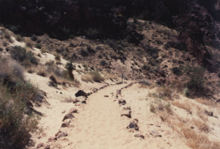
A lower section of the steep Bright Angel trail is covered with slippery wind-blown sand.
— Photo by Steve Rider
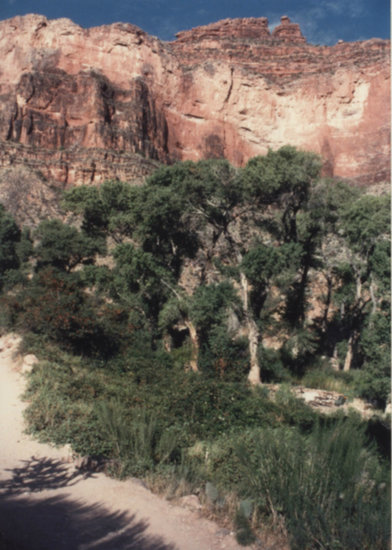
Cottonwood trees are watered by the springs of Indian Gardens. A thousand years ago, the Anasazi people lived here and farmed what is known today as the Tonto Platform.
— Photo by Steve Rider
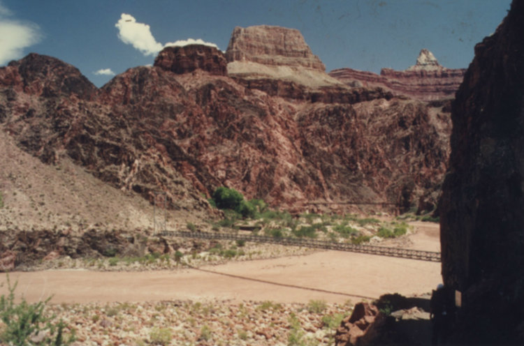
The footbridge over the swirling waters of the Colorado River transports hikers and mule-riders to the greenery of Phantom Ranch.

— Photo by Steve Rider
Nearly a vertical mile below the South Rim, Phantom Ranch and its campground nestle beneath the jagged cliffs and crags.
It is impossible to sleep.
Before we had crawled into our tent, we had noticed that the rocky outcrops around us were still warm, radiating the heat absorbed from the sun during the day. On top of that, there is hardly any breeze stirring, though we had read that cool, dense air from the North Rim of the Grand Canyon often sinks down to the river in the evenings, providing respite from the day’s high temperatures.
Not tonight.
The air is still and uncomfortably hot and dry. Some campers have their tent flaps open; others are simply sprawled out on the ground in their sleeping bags or on picnic tables, but my encounter with the rattlesnake on our hike down and warnings about scorpions have made me determined not to sleep without the protection of a screened tent around me.
In addition, I am being kept awake by the dryness of the air that is sapping our bodies’ moisture and making me thirsty. The Bright Angel Campground is fairly crowded and there is the nearly constant muffled sound of voices from people as restless as we are.
Undoubtedly adding to everyone’s discomfort are the words of the Park Ranger at the evening campfire: “Now I’m going to give you the bad news. You, ladies and gentlemen, have hiked to the bottom of the Grand Canyon, one of the deepest water-cut gorges on Earth. And tomorrow morning, you are going to have to haul your butts up and out of it!”
I had slept poorly the night before we had started our hike and the strain on our leg muscles of hiking steeply downhill coupled with dehydration requires a good night’s rest but it is obvious we are not going to get it, and sometime around 4 a.m., Steve says, “This is crazy. There is no way I am going to get any sleep. While it’s still dark let’s get moving.”
By the light of our headlamps, we load up our tent and poles in our backpacks and deliver them to the mule stable — we had discovered just before we attempted to retire for the night that for 50 bucks, the mules will haul our backpacks up to the South Rim, so we need only the light day packs we have brought and our canteens. To our surprise, the Phantom Ranch snack bar is open at that hour and we purchase a couple of trail lunches for the ascent.
As we leave the campground, the first faint light begins to glow in the east but we keep our headlamps on as we make our way over toward the river to avoid confronting snakes or scorpions. The sky brightens surprisingly fast and, by the time we reach the bridge over the Colorado River, there is sufficient light to walk without headlamps. The air now seems for the moment pleasantly cool and we are cheered by the thought that we may be able to get up and out of the Devil’s Corkscrew before the worst heat comes.
A moment to remember
Just as we start to cross the bridge, dawn’s red sunlight hits the tops of the mesas and jagged buttes and pinnacles, making them look like glowing embers and we stop to take in the spectacular scene. Just a few yards beneath us, the turbulent currents of the muddy Colorado rumble over boulders in its bed — the only sound that breaks the stillness — and the bridge vibrates with the river’s power.
There is not another living soul in sight — it is as though we are the only two people in the canyon, a moment to remember all of our lives.
The trek back along the bank of the river somehow seems less of an ordeal than it had the previous day, perhaps because we know with every step the South Rim is closer. Along with our friends Rich and Teresa, we have made reservations for that night at the venerable El Tovar Lodge, which has a swimming pool, a highly-regarded dining room, and air-conditioning.
But between Bright Angel campground and the South Rim lie 4,500 feet of elevation gain over 10.3 miles of trail and those facts provide a reality check to the elation we have felt in our view from the bridge.
We arrive at the base of the Devil’s Corkscrew and we each guzzle close to a quart of water before we begin to climb. From below, the torturous twists and turns of the trail are not very obvious and we discover to our pleasure that the steep, stony trail is in some ways easier to ascend than it was to descend for the simple reason that gravity is not forcing us forward and down at awkward angles with each step. Also, at this early hour of the day — it is around 6 a.m. — much of the Corkscrew is in shadow, tucked as it is in its own side canyon.
We pass a few lone hikers headed down who have also taken advantage of the cool morning — they must have started their descent around 2 a.m. Oddly, except for exchanging hasty greetings, no one stops to chat — everyone hiking wants to get the Corkscrew behind them.
As we climb, we make occasional brief stops to let the muscles in our legs relax but the lure of getting back to Indian Gardens before the sun begins again to turn the Corkscrew into a furnace is irresistible. We are also pleased to discover that, with increasing altitude, the temperature is staying steady or perhaps even dropping.
This seems to energize us and within an hour we have reached the sign describing the Great Unconformity — the Corkscrew is now history. The green cottonwoods of Indian Gardens and the cool shade they offer seem a prize for our morning’s efforts and we take a break for water and snacks.
Intricate features revealed
Descending Bright Angel Trail, we were rewarded with the vast, panoramic views of the canyon with its stunningly sculptured towers of rock. But on the ascent our backs are to the long views much of the time and the intricate features of the various layers of sandstone and limestone are revealed.
The National Park Service has set up labelled displays of the fossils: There are trilobites and their fossilized trails, brachiopods — oyster-like shellfish — snails and fragments of crinoids, commonly known as sea-lilies. Incredible to think that hundreds of millions of years ago this bone-dry environment was from time to time under a warm, shallow sea dotted with reefs and islands like today’s Bahamas.
Yet in between the limestone strata are the various strata of sandstone, and these show thin laminated layers meeting each other at odd angles: features known as cross-bedding, representing petrified deposits of sand left there by ancient shifting winds. This tells of Earth’s surface cyclically heaving upward, causing prehistoric seas to retreat and turning the landscape into desert as it is once more today.
In many places, in the precipitous, far-off limestone cliffs there are dark cave openings that in times of unusually wet weather may even today gush water. Most are unexplored as it is appallingly dangerous to get to them: Explorers must either rappel down from hundreds of feet above the entrances or do challenging rock climbs from below.
The caves are very ancient features and the few that have been entered have yielded stalactites and stalagmites which have been radiometrically dated to over 7 million years ago. But were these caves here before the Grand Canyon formed or are they more recent? The answers are controversial and contradicting and are part of the centuries-long debate as to just how and just when the Grand Canyon came to be.
As we climb above Indian Gardens, we encounter increasing numbers of hikers, a few bound for Phantom Ranch and the campground, many for Plateau Point.
One young couple says, “We’re almost down to the river, aren’t we?” and we gently explain that they still have a long way to go. They have no idea what the Devil’s Corkscrew is and we realize then that they are not following a map.
In addition, the young man is wearing open-toed sandals and at the end of the hike is likely to have blisters on his feet the size of golf balls. But rather than trying to scare them with dire warnings, we tactfully suggest that, given their inexperience and the rising temperatures as they descend, they might want to turn around at Plateau Point — which, to be sure, is far deeper into the canyon than most visitors go.
They seem grateful for the advice and head off downward energetically. As the saying goes, “Experience is the best teacher.”
End in sight
It is now late morning and we are approaching the last switchbacks of the trail before we reach the South Rim. We are dusty and sweaty and obviously look tired but are exhilarated to see the end of the challenge so close now.
The temperature has continued to remain steady as we climb and now stands in the low 70s — fine for hiking. This section of the trail is crowded with visitors, many with little kids, doing just as my family did those many years ago — descending a few hundred feet on the Bright Angel Trail to get a feeling for being in the canyon instead of just looking at it, as it were, from the outside.
A ranger we talk to later informs us that a survey has revealed that the average time visitors actually spend looking at the Grand Canyon is a minuscule 12 minutes before they head off to the souvenir shops, the game rooms, and swimming pools of the hotels, or one of the numerous food services. To me, this is comparable to someone’s standing on a bluff on the New Jersey side of the Hudson River, taking a couple of quick selfies with the skyscrapers of Manhattan in the background, and texting friends that they have been to New York City.
Following directions in our trail guide, just before we reach the rim we take a look into an inconspicuous hollow above the trail and there we see pictographs left by the Anasazi or one of the other ancient peoples who have made their ways into the canyon. A handprint and figures of deer and other animals appear in red paint, surprisingly well-preserved in this dry environment even though vandals have managed to find and mar some of them.
Their presence emphasizes the long history of the trail and evokes admiration for people with primitive equipment who must have been motivated by the same sense of awe and wonder that lures hikers today.
As we arrive at the rim, several people come over to ask if we have come up from the bottom and seem impressed when we answer in the affirmative. One elderly man says, “It must be a great experience,” and sounds wistful.
“Yes, yes it is,” is our response. “It really is.”
Not particularly eloquent, of course — but sometimes simple words convey the most truth.
In any case, no question we hear matches what a park ranger tells us he was asked upon emerging from one of his many trips into and out of the canyon. A middle-aged couple approached him — dusty and sweating and sunburned like ourselves — and asked if he had been to the bottom, and when he replied that he had, the woman asked, “Is there anything down there?”
As the saying goes: If you have to ask a question like that, you would never understand the answer.
We head for our hotel, a hot shower, a good dinner with a celebratory glass of wine, and a well-deserved night in a real bed. And, as was true of so many before us who have descended into the depths of the Grand Canyon, we dream.
Location:

— Photo by Steve Rider
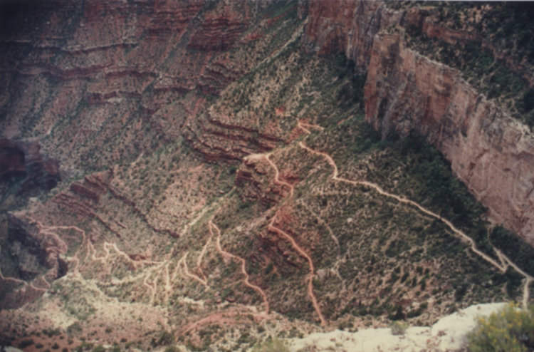
Mike Nardacci stands at the trailhead for Bright Angel Trail. In the center of the photo and 3,000 feet lower with its spectacular view of the Inner Canyon is Plateau Point, the goal of many day hikers.
— Photo by Steve Rider
At the beginning of the Devil’s Corkscrew, a sign stands next to the otherwise unobtrusive Great Unconformity. At right, the precipitous cliffs of the Vishnu Schist plunge nearly a quarter of a mile, forming the Inner Canyon.
— Photo by Steve Rider
The torturous switchbacks of the Devil’s Corkscrew: During much of the day, there is no shade in the Corkscrew, making passage through it a challenge.
— Photo by Mike Nardacci
The turbulent Colorado River is met by the Bright Angel Trail. Spanish explorers named the river for the faded-brick color of silt and sand it carries. In the background rise mesas and buttes of the Upper Canyon.
Everyone remembers the first time they see the Grand Canyon.
Mine came over half a century ago when I was 14 and it is still burned into my memory along with my first sight of the Giza pyramids; my first close-up look at an erupting volcano; and my first view — from a hillside fragrant with pine resin called The Pnyx — of the Parthenon at night glowing in subdued flood lamps above the noisy, twinkling streets of Athens like a vision from myth.
My family was on a cross-country trip and we had driven up from Phoenix, Arizona that day. The first half of the drive had been blisteringly hot.
Cars did not have air-conditioning in those days and my mother and father had shared the driving, but even today it is a tiring trip, passing first through forests of giant saguaro cactuses, then ascending through cool mountain meadows where elk wander and, skirting Flagstaff, heading into high desert where the apparently endless flat terrain gives no hint of the awe-inducing landscape that lies just to the north.
We arrived around 10 at night at the venerable Bright Angel Lodge where my parents had reserved a cabin that was close to the South Rim of the canyon. They were both looking forward to getting a shower and a good night’s sleep but I remember being appalled that they did not first want to see the canyon. Assured by the hotel clerk that there was a safe viewing deck right behind the main lodge, I took off on my own, promising to join the family at our cabin in 15 minutes.
The clerk directed me to a doorway that led out onto the deck and it took a few moments for my eyes to get accustomed to the darkness. The bright first-quarter moon had risen in the eastern sky and slowly there emerged from the dark vastness the silhouettes of great craggy pinnacles and towers and though in the dark it was impossible to gauge size or distance, I could tell what lay before me were massive structures stretching to the horizon.
Far, far below was what appeared to be a thin, meandering line drawn in softly luminous ink — my first glimpse of the far-away Colorado River. A mild breeze was rising from the depths, carrying with it the fragrance of sage and other desert plants, an odor I have heard described as “desert incense.”
An eerie howl was the only sound that broke the overwhelming stillness — perhaps somebody’s dog, though at 14 I was sure I was hearing a coyote. However — I have since spent enough time in the Southwest to realize that it probably was a coyote as these critters are ubiquitous in the deserts.
At any rate, with that unearthly sound, I suddenly became aware that a dark, precipitous abyss lay before me and for a moment I steadied myself against the retaining wall that surrounded the deck as I was overcome with the vertiginous sensation that I was about to be pulled over the side. I remember withdrawing into the light of the lobby of the lodge where everything was on a more human scale and running to our cabin.
The next morning, my father took my sister and me on a short hike down the iconic Bright Angel Trail that leads down to the Colorado River. We were on a tight schedule and had to meet relatives in Los Angeles in two days but Dad wanted us to have the experience of being down in the canyon instead of just seeing it from the top.
My mother declined and opted for a walk on one of the paths that run along the canyon rim, meandering through desert plants and offering dizzying views of the spectacularly colorful rock formations below.
My recollection is that we walked not more than a half-mile down the steep, dusty trail and foolishly had not brought any water. The South Rim is at 7,000 feet and tends to be fairly cool even in summer, but one of the great misconceptions novice hikers entertain — and we were definitely novices! — is that temperatures down in the Canyon are cooler than at the rim. (Fact: Temperatures tend to decrease with increasing elevation, and increase with decreasing elevation, a lesson I certainly knew many years later but did not appreciate until I hiked with a friend all the way to the bottom.)
I had been a rock collector since I was around 5 years of age but at 14 I knew very little about geology though I had read in a guidebook that the canyon had been cut by the Colorado River over millions of years. I was fascinated by the fact that the rocks were in layers of many different colors even if I had no idea why — Dad probably tried to explain that to me, but who remembers lessons from when you are 14?
We probably descended 500 feet or so below the canyon rim — following, as it turns out, a route first used by the ancestral pueblo people long known to history as the Anasazi. Beautiful as the scenery was, I remember being surrounded by the massive stone forms and experiencing again the feeling of vertigo as we gazed off into the immense gulfs of the canyon.
It was with some relief that my father told us that we had to head back up to meet Mom and take a drive along the rim to see more of the awesome scenery before we left on the next leg of our drive west. In all, we spent less than 24 hours at the canyon — fairly typical for the average tourist even today.
But that brief descent of the Bright Angel Trail remained lodged in my memory as one of the highlights — albeit a bit scary — of our California trip. And the sight of the far-away bottom of the canyon and that narrow-seeming Colorado River surely fired my determination to come back someday and hike all the way down.
Return to the canyon
It was many years later that I returned to the Grand Canyon (rather more than fully grown!) but this time with several friends: a fellow hiker named Steve with whom I planned to hike to the bottom and tent overnight in the Bright Angel Campground near legendary Phantom Ranch, and an old high school buddy named Rich and his wife who were going to do the mule ride down to the bottom and stay in one of the rustic (but air-conditioned) cabins at the Ranch.
We arrived on a deceptively cool August evening after a long drive from New Mexico and spent the night before our trek in the park campground. This turned out to be a mistake, because the rule most campgrounds state about “quiet hours” after 10 p.m. are routinely ignored, and I remember spending an uncomfortable night trying to sleep while boomboxes near and far broke the stillness with rock, rap, and mariachi music.
I recall waking from what little sleep I had gotten with a sore back and thinking how nice it would be to find a quiet hotel room somewhere and sleep for a dozen or so hours instead of embarking on what might be the most epic hike I had ever made.
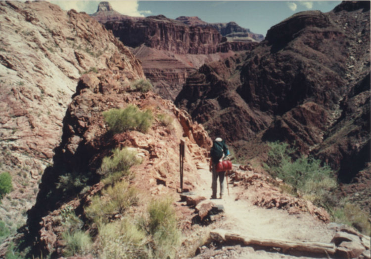
But around 8 a.m., backpacks on, we parted from our friends, planning to join them at Phantom Ranch at the bottom and began our descent of the Bright Angel Trail, one of several maintained trails that descend into the canyon. It follows a prehistoric fault line that slices through the rock layers and which subsequently became a channel for flowing water — rare in these times — which eroded a pathway affording the ancient Anasazi people and modern hikers access to the bottom of the Canyon.
Layers reveal history
The layers of rock into which the Grand Canyon has been incised by the Colorado River can be thought of as a stack of books revealing segments of Earth’s history, with the most recent events in the “book” on top. From a distance, the strata (layers) may look thin, but hiking down through them makes one realize their immense breadth. Individual strata may be hundreds of feet thick, each one representing a dramatic change in the environment in which it formed.
Three of the broader layers are limestone, known in order of age from youngest to oldest as the Kaibab (Permian Period), the Redwall (Mississippian Period), and the Muav (Cambrian Period), making them between 250 and 530 million years old. These layers formed in warm, shallow seas and contain characteristic fossils such as trilobites and crinoids — also called “sea lilies,” but which in spite of their flower-like appearance are actually animals.
Yet they are interspersed with layers of sandstone called the Coconino, the Esplanade, and the Tapeats and major shale layers known as the Hermit and Bright Angel. The sandstone formed at times when the ancient seas receded and this part of the Southwest, like today, was desert characterized by vast fields of windswept dunes. Some of the outcrops exhibit the ancient tracks of lizards and other reptiles that scampered over the dunes.
But the shale layers formed when the area was under very deep waters and is often dark, indicating an environment that was oxygen-poor and mostly hostile to life, showing occasional worm tubes but few other signs of living creatures.
At the very bottom of the Canyon at the level of the Colorado River is a near-quarter-mile thick layer consisting of the Vishnu Schist, which is metamorphic, infused with fingers of the igneous Zoroaster Granite. These rocks are well over 2 billion years old and are indicative of a whole different range of formation processes: a veritable library of the region’s changing geologic history.
The strata weather and erode in different ways and at different rates, and this fact is responsible for the stunning sculptured appearance of the canyon’s landscape. Very hard rocks — such as the limestone, sandstone, and schist — tend to weather into huge vertical slabs that spall off in massive vertical slabs producing steep, precipitous slopes with enormous angular boulders at their bases.
Shale layers, on the other hand, are far less resistant to agents of weathering and erosion and result in gentler slopes, often littered with small pebbles and gravel. These processes can be observed in our own Thacher Park where the limestone rock layers of the Indian Ladder Trail have formed steep cliffs, but the long, gentler talus slopes beneath them are composed of dark shale and brittle sandstone layers, stretching down from the Helderberg plateau toward Altamont and New Salem.
At the canyon, the thickness of the strata and the varying steepness of the slopes result in the frequently scary exposure but always spectacular views offered by the various trails that descend to the Colorado River. It is not unusual to be hiking on a trail that is less than five feet wide with a sheer drop of several hundred feet off one side, and it takes us a couple of hours of hiking before we even begin to get used to the exposure, made worse by the fact that, when a mule train passes, hikers are required to stand on the outside until the last mule has gone by.
Believe me, it is a memorable experience to be perched on the edge of a cliff with a 500-foot, almost-vertical drop behind you while an odoriferous mule carrying a terrified-looking passenger lumbers by you with only inches to spare.
Indian Gardens
After about three hours, we arrived at the area known as Indian Gardens, a popular resting and watering place for hikers. Often thought of as the halfway point on the descent, it is actually about two-thirds of the way down from the South Rim in terms of elevation loss.
It is located at the interface between two important rock layers — the Muav Limestone and below it the Bright Angel Shale — part of what is known as the Tonto Group (no relation to the Lone Ranger’s companion). Here the Bright Angel Shale has weathered out into a broad plateau known as the Tonto Platform and offers respite (briefly!) from the steepness of the trail.
The Muav Limestone is somewhat permeable and can function as an aquifer, allowing the development of caves and small conduits carrying water. But the Bright Angel Shale is an aquiclude, meaning that water cannot pass through it and so the contact between the two layers features numerous springs, some with potable water.
Long ago, the ancient Anasazi people had descended the trail through the Bright Angel fault and built a series of small pueblos and kivas — underground religious structures — from the endless supply of rocks spilled down from higher up and farmed the Tonto Platform — hence the name “Indian Gardens.”
Dusty and dilapidated, the ruins of the pueblos are still visible and leave one to wonder about the mysterious people who passed their lives in this hauntingly isolated spot.
It is a gorgeous place, featuring some shade-offering cottonwood trees, and it is surrounded by towering buttes and pinnacles of varicolored rock. Their tones change from moment to moment with the movement of the sun and they cast deep, mysterious-looking shadows across the rocky wilderness.
The platform itself consists of gently rolling hills incised by steep valleys that in wet weather transport water to the Colorado River. The relative moistness of the plateau has allowed an array of desert plants to flourish there, such as cactuses and wild sage.
It was while I was following a small side trail that leads to a spring where I planned to fill my canteens that I encountered one of the canyon’s more interesting wild residents. I came upon what appeared to be a yard-long strip of pinkish leather draped over a scraggly-looking shrub and the absurd thought briefly passed through my mind that someone has lost a belt.
All at once, its nether end went vertical and an electric-sounding buzzing broke the stillness of the canyon. I froze in my tracks and realized it was a specimen of the Grand Canyon Rattler that lives nowhere else.
We regarded each other suspiciously for a few moments and then, staying well out of its private space, I made a wide arc and continue on my way, carefully watching it as I went. After a long moment, the buzzing stopped and its tail dropped. It had vanished when I returned with my full canteen so the encounter ended well for both of us, but, suitably alerted, I watched every step I took before I returned to the main trail.
As we were enjoying the leafy shade and a long cool drink of water along with some salty snacks — it’s important to maintain one’s electrolyte balance when hiking in heat — a line of mules and riders approached. The mule team leader known as the Wrangler urged all of the riders to drink plenty of water and a couple of them showing signs of overheating were hosed down with cold water from a spring.
We chatted briefly with our friends, Rich and Teresa, whose clothes were covered with dust and who admitted to looking forward to their air-conditioned cabin and a cool shower. They reported a few anxious moments on their ride as the mules apparently love to walk right on the outside edge of the trail where one misstep would send both mule and rider tumbling into the abyss. We planned to meet that evening in Phantom Ranch’s canteen for dinner.
Great Unconformity
Leaving Indian Gardens, hikers get a bit of a shock for they are soon at the top of The Devil’s Corkscrew, a dizzying series of very tight switchbacks that descend over 1,300 feet in approximately 3.5 miles. The Corkscrew offered virtually no shade and the temperature was rising steeply.
The sense of exposure is extreme and with every step hikers become aware of the fact that they are being engulfed by the lower depths of the canyon. One advances with a mixture of awe and trepidation with each dusty step.
As the trail begins its descent, a National Park sign alerts hikers to the fact that they are now passing through what geologists call the Great Unconformity. In simple terms, a geologic unconformity is the boundary between two rock or sediment layers that differ widely in age and often in composition.
A simple example can be found outside the door of anyone living on the Helderberg Plateau or in the towns that snuggle at its base. The surface sediments here are Pleistoscene — rocks and soil left behind 10,000 or so years ago when the glaciers retreated. But the sediments sit upon rock strata that come from the Devonian Period — 400 million years ago — or even earlier. That time gap between them represents an unconformity of hundreds of millions of years.
The Great Unconformity is in no way attention-grabbing, and without the sign no one lacking an extensive knowledge of geology would be likely to take a second look at it. Layered 550-million-year-old Tapeats Sandstone rests tightly on the quarter-mile-thick Vishnu Schist — a metamorphic rock — containing intrusions of the igneous rock granite.
The schist represents very ancient shale layers pressed and folded and cooked in a mountain-forming episode called an orogeny. It is all that remains of what was once a range of near-Himalayan heights that rose around 2 billion years ago — close to half of the age of the Earth — and was then ground down steadily over hundreds of millions of years by the agents of erosion.
In other words — in a space too thin to place one’s fingers in, something close to 1.8 billion years of Earth’s history has been wiped away. We know this because, in many other places in the United States and in the world, rocks of the intervening eons have been discovered.
The Great Unconformity can be seen in other parts of the Southwest, but nowhere is it visible in a setting more dramatic than this. And given the hardness of this inner canyon rock, the Devil’s Corkscrew features drop-offs between its tight switchbacks that are vertigo-inducing and we found ourselves grateful that we were not on mule-back.
Reaching the river
It was now near noon, and as the sun had ascended into the cloudless Arizona sky, its light being concentrated in the confines of this canyon-within-the-canyon, the temperature soared. Descending the meanders of the Corkscrew is numbing: left turn, right turn, left turn, right turn again down a rock-strewn trail, kicking up dust with every step and trying hard to avoid deposits of mule-poop.
The gradient was so steep we had to force ourselves to hold back from a trot — unthinkable in this heat and with such unstable footing. In the stark sunlight, the varying colors of the rock layers seemed to be bleaching to dull shades of tan and everywhere there were dusty cactuses of several kinds, constant reminders that we are in the desert — as if we needed such reminders.
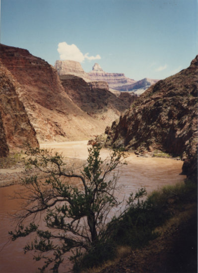
In less than an hour, we reached the banks of the Colorado River, and what appeared from the South Rim to be a narrow, lazily-moving muddy stream was revealed as a roaring flood, its waters faded brick-red from the rust-colored sediments it carries.
Perched on the bank was a small shady shelter where hikers could fill their canteens with fresh water and there is usually a park ranger to offer aid and answer questions. Everyone entering the cool interior remarked on the oppressive dry heat and to our astonishment the ranger told the assembled group, “You folks are lucky — it’s only 107 today. Yesterday at this time it was 123!”
Whatever good news that represented, the fact is that we were still 2.3 miles from the Bright Angel campground near Phantom Ranch. Before we started our trek, we had cut down what we were going to carry to the absolute minimum equipment we would need for a single-night stay — about 15 pounds each. Descending the trail in the cooler morning, the packs had not seemed so much of a burden.
But as we commenced our hike along the river toward the campground they seemed to gain weight with each step and there was absolutely no shade. Moreover, the rock-littered, dusty trail along the river is not flat — it goes up over and down a series of hills and gulches formed from massive piles of talus that have spalled off from the higher elevations.
In the wilting heat and with the droning of the river’s rapids, the hike is punishing. The spectacular scenery rising above us offered little consolation for the ordeal and we realized that no matter how much water we guzzled from our canteens on the way down, it was not enough: We were feeling the effects of dehydration.
On to camp
After what seemed like hours — but was really only about one — we spotted the sturdy metal bridge across the Colorado that leads to Bright Angel Campground and we gratefully crossed it, only a few yards above the roiling waters of the Colorado River.
On the far side near some cottonwood trees are the remains of still another Anasazi pueblo and a kiva close to where the Bright Angel Creek spills down from the North Rim of the Canyon to join the Colorado — another green place in the desiccated wilderness of the canyon.
Beyond them is the campground, and after checking in we hit the snack bar and guzzled what must have been two quarts of cold lemonade each. We then proceeded to put on our bathing suits and go to join other exhausted hikers sitting in the creek and letting the cold stream spilling down from the North Rim of the canyon refresh us.
Later in the afternoon, Rich and Teresa arrived and showed us their cabin. It is Spartan — but its air-conditioner works; it has water for hot showers; and. though the beds look like they came from a college dormitory, we are assured that they are clean and comfortable.
We assemble at dinner time in the Phantom Ranch canteen. Meals are served family-style at long tables — like at a church supper. Steve and I have pre-ordered beef stew with chocolate cake for dessert, and perhaps it is the effect of our day’s ordeal or perhaps it is the spectacular setting but the humble stew tastes like the specialty of a five-star restaurant and the cake seems the equivalent of some gourmet French pastry.
In any case, we wash it all down with glass after glass of cold lemonade and, after dinner, Rich and Teresa head off to their air-conditioned cabin for a good night’s rest in a real bed. At dawn the next day, they will again mount up on their mules and head back up to the South Rim.
They will be following the South Kaibab Trail, which most guidebooks tell hikers ascending the canyon to avoid as it has almost no shade and is even steeper than the Bright Anger Trail. Steve and I head over to a small amphitheater located near the river for the evening ranger presentation.
The temperature is still in the nineties, but what is a ranger presentation without a bonfire? So the woman ranger who is conducting the presentation has built a small fire that crackles and spits agreeably, but in this dry heat not one of the two dozen or so hikers gathered for her talk wants to be near it.
Before she starts, we have time to contemplate the setting: We are seated on primitive benches situated on some of the oldest rock on Earth’s surface, surrounded by towering mesas, buttes, and pinnacles slowly sinking into purple shadows in the approaching twilight. Far above us and several miles away, tiny lights from the hotels scattered along the South Rim glitter dimly like mirages and above them in the clear violet sky the planet Venus gleams.
The ranger takes the podium and says to the gathered crowd: “Congratulations everybody! You have hiked to the bottom of the Grand Canyon, something very few people ever have the opportunity or the stamina to do!”
She points out the towering structures of stone and explains the origin of some of their names: Zoroaster Temple, Cheops Pyramid, Shiva Temple, Vulcan’s Throne, Isis Temple — names to conjure by if we were not all too tired to conjure. She talks about the geology of the rock strata and their mind-numbing age and explains how the flowing waters of the Colorado River and the thousands of small side canyons have carved this great abyss over millions of years. The crowd is silent — partly out of exhaustion but mostly in awe of her presentation
Then all at once she says, “Now I’m going to give you the bad news. You, ladies and gentlemen, have hiked to the bottom of the Grand Canyon, one of the deepest water-cut gorges on Earth. And tomorrow morning, you are going to have to haul your butts up and out of it!”
The poetry of the moment disappears, and all at once it hits us: Today we hiked down into this spectacular place in the oppressive heat. Tomorrow we have to do it in reverse — and the Devil’s Corkscrew looms in our imaginations like the challenge of a lifetime.
Location:
The Enterprise — Melissa Hale-Spencer
Stories abound about this house with a tower in New Salem.
The mist-enshrouded history of Ireland is replete with stories of ghosts and other supernatural manifestations. I have Irish ancestors on my mother’s side, and from the time I was very young I became aware of the fact that some of them believed in ghosts the way the rest of us believe in traffic lights: They are there and we have to deal with them.
When I was in college, I attended the wake of an elderly Irish family friend in a small town in the Adirondacks and one of my great aunts approached my mother to express her grief and then said, “Oh Mary Jane, it’s so sad. But I knew someone was going to die. A few nights ago, I woke up and there was a ghost rattling rosary beads against my window.”
You had better believe that that story got told and re-told at family gatherings for years afterward!
But whatever part our family history might play in my interest, I have had a fascination with tales about ghosts from a very early age — I wrote my first ghost story when I was 10. But in my later years, my interest has centered on the stories and psychology of people who believe in ghosts.
That undoubtedly played a large part in my decision to write my doctoral dissertation in American literature on the fiction of Shirley Jackson, whose short story “The Lottery” and whose novel (subsequently a film) “The Haunting of Hill House” made her famous.
One critic characterized her works as combinations of “sorcery and psychiatry,” which nicely nails them down.
And over the years, my cave-exploring activities and my work with the Heldeberg Workshop have occasionally introduced me to perfectly reasonable-seeming, rational people who will tell me point blank that they have had an encounter with something other-worldly, that they live in a haunted house or that they know intimate details about one.
But my personal contact with stories of several reputedly “haunted” houses and sites in the Helderbergs began a good number of years ago when I was teaching a course at the former Vincentian High School in creative writing. At the time, the “Foxfire” series of books were very popular, detailing as they did folk tales and ways in the back hills of Appalachia.
I set my senior students on a project to track down interesting people and stories from the Helderbergs and write them up. As a result of my summers at the Heldeberg Workshop, I had become friends with Frieda Saddlemire, the legendary school teacher and historian from Knox, and she had suggested several contacts.
While all of them turned out to be interesting and earned the students who wrote about them respectable grades, two of the stories the students had ferreted out were remarkable, though one — of which much more later — never got written up by the students who had uncovered it.
It got shot down fairly quickly as a result of an interview I had with a person connected to the story. Subsequently, I elaborated on the events I heard about in that interview and turned them into a novel I am struggling to get published.
(The other story tracked down by two students is one I have been attempting to gain more information about for many years with virtually no luck. It involved a fantastic tale that they dug up as a result of a meeting with a source who insisted on remaining anonymous. While it did not involve ghosts, it was the sort of thing that a writer with the mentality of H.P. Lovecraft might have conjured, and it deals with that very peculiar-looking vine-covered building that looms darkly on the west side of the Knox Cave Road between Warner’s Lake and the village of Knox. But as I am still in hopes of someday tracking down the truth. I will say no more at this juncture!)
A dozen or so years afterward, I had confided in a few friends and associates that I was at work on a novel about a haunted house, based on a story that a pair of my students had uncovered in that folklore assignment. But I guess that kind of confidence — like a bit of juicy gossip — is very difficult to keep under wraps, and before long I was being contacted by various people who claimed to have been involved with ghosts or knew someone who had been.
Most of the stories seemed to involve spirits of remarkably uninteresting character. But a couple were intriguing.
One concerned a venerable old Victorian-style house on a road south of the village of New Salem in which one of the officers of the Heldeberg Workshop lived. She had invited the workshop’s board members over one fall night for a gathering, and a number of us admired the beautiful antiques she and her family had collected over the years.
She then informed us that her house had what she described as “the most interesting antique of all: We have a ghost.” Or more precisely, they had a “poltergeist,” which is described as a “mischievous spirit.”
She asserted — and her husband and teen-aged children backed her up — that soon after they had moved into the house, they would sometimes come home to find furniture moved around and drawers pulled from dressers and the contents — usually socks and underwear — would be spilled onto the floor; rugs would be found rolled up, and locked doors would open and close on their own.
Curious events — but somewhat silly and not particularly threatening. The events had become less frequent in recent months, and the family had arrived at a theory: Before they moved in, the house had stood empty and somewhat dilapidated for a number of years. They concluded that a spirit in the house had felt lonely and the arrival of living, breathing humans with children had sent it into paroxysms of joy, which it was expressing through a series of mischievous acts.
Well, perhaps.
Another, creepier tale came to me by way of a self-described psychic — whose name I will not mention because I have always believed she derives way too much publicity by mentioning it herself! In any event — hearing that I had been at work on a novel about a haunted house — she contacted me and told me that a very old home in the beautiful valley of the Onesquethaw Creek south of Clarksville had once harbored a malign spirit.
Every Christmas Eve — precisely at the stroke of midnight, she told me — the windows in one upstairs bedroom exploded outward, sending shards of glass and wood flying to the ground. She asserted that the owners of the house had called upon her to perform some kind of exorcism and that, as a result of it, the events had stopped.
She also insisted that under no circumstances should I approach the owners as they did not want any publicity and, in any case, would deny everything.
Again — well, perhaps
But then — why had she contacted me in the first place? However, I am getting ahead of my story. Something had been brooding in my mind for a number of years.
Back when I had been teaching that creative writing class at Vincentian High School, two young men among my students had come to me with a tale they had gotten from a relative of one of the students who lived in New Salem.
There was a house there, they said, that had long had the reputation of being haunted and, although it was at the time unoccupied, they had the name and telephone number of a woman who had lived there not long before with her husband.
The young men wanted me to contact her and ask if there was indeed anything to the story and if so if she would be willing to be interviewed so they could write up their folklore project. Therefore, one school day before classes began, I called the number; I got an answering machine and left my name, the school’s phone number, and a rather vague reference to the fact that I had been told she might have an interesting story to tell about a house in New Salem.
Less than three hours later, while I was just wrapping up a lesson before the bell rang to change classes, the school secretary knocked on my classroom door and told me I had a visitor. As it happened, my lunch period followed, and so I was able to meet and speak with her.
She proved to be a young, attractive woman perhaps in her early thirties, quiet, composed, cordial if rather formal, and not at all seeming to be a nervous type. There was a small conference room where we could talk; she had requested that we speak privately and I anticipated that she was about to tell me that the young men who had given me her phone number were prying into something that was none of their business.
She began in a rather offhand almost bland manner, telling me that she had gotten my phone message and that it was really not a good idea for the young men to go knocking on the door of the house in question.
But her demeanor changed rather abruptly. She began to recount a series of increasingly hair-raising events that she insisted had happened to her and then to her husband and within 20 minutes she was literally in tears and shaking, beseeching me to tell the young men to stay far clear of the house.
Her tale was punctuated with the refrain that has probably been spoken by everyone who has had a bizarre experience that might involve the supernatural: “I know you will think this is crazy, but you must believe me.” After all these years, the interview still gives me goosebumps when I think about it.
The two students who had uncovered the story were disappointed when I gave them a vague reason not to pursue it — something to the effect that the current owners would deny everything and certainly would not allow the students to poke around. They subsequently found some other topic to pursue the nature of which I have long forgotten.
But the story of the house in New Salem had planted itself in my mind and — no pun intended — began to haunt me. I took a drive out Route 85 to get a look at it and noticed at once how it stood out from other houses in the village.
It had a tower on it — commonly called a “widow’s walk,” which indicated it had been built in the 1800s. But most striking was its color: Unlike most of the other houses in New Salem, which were painted white or yellow, this one was chocolate brown with turquoise trim.
But unlike the stereotypical image of haunted houses, it appeared well-maintained, with lawn and shrubbery neatly trimmed. And then there was its location. Obviously being in a hamlet with “Salem” in its name is evocative — but this house, unlike the haunted houses of Gothic thrillers, did not stand alone on a wind-swept moor or surrounded by dense forest.
It sat comfortably surrounded by close neighboring homes with their potted plants and bird-feeders and flower beds — in no way seeming to be the setting for the frightening story the woman had told me.
And the story was this: She and her husband had moved to upstate New York from a fairly rural area in a neighboring state. Her husband was, I believe, an insurance agent and worked in Albany, eight or nine hours a day, Monday through Friday and occasionally on weekends.
She was an artist and from time to time had worked as a substitute art teacher in various private schools as she was not certified in her former state or New York but on moving had decided to take a year off and concentrate on her paintings — acrylics and watercolors.
They had rented the house because they enjoyed the quiet of a home town and it was roomy and partially furnished. Previously, they had lived in an apartment and did not have a great amount of furniture of their own.
Rent was low, the house was conveniently located on a good road, and the views of the Helderbergs from the house — especially from the tower where she set up her studio — were gorgeous and inspiring.
Shortly after they moved in, some odd things began to happen — ominous music please! She would go up to her studio to find her easel knocked over and paint daubed onto a partly-finished canvas or onto the floor.
If she went out to shop, she might come home to find furniture moved around. (Poltergeist?) She contacted their landlord who insisted that he had not been in the house but that vibrations from heavy traffic on the highway might have caused things to spill or move around. (As the kids say — “Yeah, right!”)
On a couple of occasions, she would look out of a window and see a young auburn-haired boy, perhaps 12 or 13 years of age, in their backyard, staring up at the house. When she would go outside to ask him what he wanted, there would be no one there. (More ominous music!)
Then things got more unsettling. On one sunny fall afternoon, she was in the backyard of the house picking some late-blooming flowers for a bouquet when she looked up at the house and saw the boy inside — watching her from a window.
She dropped the flowers and raced inside — but the boy was gone. The front door was locked from the inside and the only other entrance was the rear door through which she had come in.
She called out and searched every corner of the house, including the basement but there was no sign of him. Shaken, she went to a neighbor’s house and inquired about the boy and later reported the incident to the sheriff. But her description did not fit that of any kid living in New Salem at the time and no one else had reported seeing him.
Now — in any ghost story, this is the moment of decision, or as a character in a Shirley Jackson story says, the moment of discovery of “the disembodied hand in the soup”— and generally the humans involved make the wrong decision.
Why would anyone stay in a house in which such things are going on? And, when I had asked the woman this question during our meeting, she gave the expected answer: The house was conveniently located, it was airy and roomy, it was well-kept-up, and the rent was very reasonable. (“And now we know why!” exclaims the reader.) And none of these events had taken place when her husband was at home.
Then things got much nastier. While she was taking a shower one morning, she heard the door to the bathroom suddenly open a crack and she swore she heard boyish giggling coming from just beyond.
She screamed and lunged for her bathrobe, but of course there was no one there when she opened the door fully and both doors to the house were locked from within. She hesitated to call the sheriff to report an intruder because she had not actually seen anyone and saying she “thought” she heard laughter would not be taken very seriously.
One day when she was vacuuming the living room, she looked out and saw a group of three or four kids sitting on the steps in front of the house with their bikes lying on the lawn. She went out and asked the kids if they knew of any boy in the area who might fit her description.
She said the kids had snickered and told her that other people living in that house had reported seeing such a boy. Their story was that, in the early 1900s, a family had lived in the house whose adolescent son had been climbing on the cliffs above New Salem with some friends and had fallen to his death. From that moment, his spirit had haunted the house.
Convinced that the kids were simply trying to scare her, perhaps having heard her stories about the boy from their parents — such news gets around pretty quickly in small towns — she was determined not to be driven out of the house by a disturbed adolescent. But, of course, the kids’ tale now began to loom large in her mind.
There was one climactic incident that finally drove her and her husband to leave. On a brilliantly sunny Sunday afternoon, she and her husband were in the living room. He was lying on the sofa, watching a football game on TV, and she was reading.
Although the room was cheerfully bright, she had a reading lamp on behind her. Suddenly the light went out and the TV clicked off. Just as she was about to say, “The power’s out” to her husband, the room went black.
Now — understand, the window shades were up and the views out the windows were the usual ones: other houses, the street, the cliffs above the town. But no light was coming in.
It was as though the windows were nothing but illuminated paintings on the wall. The interior of the room was black as pitch and she could see nothing. She called out to her husband, but there was no answer.
Incredulous, she got to her feet and groped her way toward the sofa, tripping over a small footrest on the floor. She swore she heard again the boyish giggling and suddenly the darkness went away and the room was light again.
However, her husband was lying on the floor writhing as though he were having some kind of seizure. When she knelt next to him and called his name, she reported that the writhing suddenly stopped.
With his body contorted, his face broke into what she called “the most hideous grin I have ever seen in my life.” He then began to speak in an eerily smug, adolescent boy’s voice punctuated with a demented-sounding giggle. He told her that the house belonged to him and that he wanted her and her husband out now.
Terrified, she stood up incredulous of what she was hearing — when suddenly her husband’s body relaxed and blinking his eyes rapidly he said something like, “Honey? My God, I fell off the sofa! Did I fall asleep?”
He was not aware of the episode of blackness nor of the events that had followed.
They left the house that night. If she explained to me how they had managed to break their lease, I have long since forgotten. Her husband had supervised the moving of their furniture as she refused from then on to set foot in the house or for that matter in the hamlet of New Salem. And once they were out, she had never experienced any such events again.
I remember telling this story to Frieda Saddlemire — well, parts of it, anyway — and she nodded and said that stories had abounded about that house for years, some quite different and less threatening than the ones the woman had told me.
“You know,” she said — lowering her voice though only the two of us were there —“people up here in the hills really believe that kind of thing.”
But, of course, if a viewer flips around cable stations one by one it becomes obvious that there are millions of people in this country who believe — or want to believe — “that kind of thing,” given the number of ghost-chasing, haunted-house investigating shows that are on the schedules.
My novel is called “Come From the Star Lands,” taking its title from an eerie poem by John Greenleaf Whittier about a ceremony that calls back the departed.
It grew from being a novelette to quite a lengthy novel, and in it I have incorporated several of the other ghostly tales about the Helderbergs — called the “Helder Hills” in my book — and have managed to bring in some of the other non-supernatural tales of local folklore I picked up along the way.
The Helderbergs have a history and a folk tradition as rich as that of William Faulkner’s Yoknapatawpha County, though his stories involve ghosts of quite another kind.
That house in New Salem looks now rather different from the way it looked when I first heard about it and the stories surrounding it. Painted a light shade of green with dark green trim, it sits comfortably among the other rather New Englandy-looking houses in the village — though that tower still seems a bit foreboding.
I know many people in the area, and to my knowledge whatever scary reputation the house once had has long passed, perhaps remembered only by some of the oldest residents of the hamlet and surrounding lands.
As I pass it, I am reminded of the closing lines of Emily Bronte’s classic novel “Wuthering Heights.” To paraphrase: Seeing today this well-tended, rather dignified-looking dwelling, it is hard to imagine unquiet slumbers for the sleepers in the quiet earth.
Location:

Mike Nardacci, on an expedition with the Cave Research Foundation into Crystal Cave, stands in front of the Collins farmhouse, restored and maintained by the National Park Service.
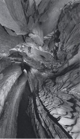
— Photo by Art Palmer
The huge passage in Crystal Cave is known as The Grand Canyon. For many years, Floyd Collins's coffin was displayed here.
The shadowy entrance to Sand Cave has a sandstone cliff above it. Within the cave, Floyd Collins met his tragic end.

A kiosk is at the start of the tourist trail leading to Sand Cave. It was here that the “carnival” took place while rescuers made chaotic attempts to free Floyd Collins from the cave.
Floyd Collins’s tombstone is in the mammoth Cave Baptist Church cemetery. An inscription calls him “the greatest cave explorer ever known.”
The death of farmer and caver Floyd Collins and the subsequent grotesque events — including some legendary ghost stories — constitute a strange chapter in the annals of American folklore. The setting for the tales is the vast karst area of central Kentucky known as the Chester Upland under which the corridors of Mammoth Cave, the world’s longest, wander for over 500 miles beneath the forested plateaus.
Derided all too frequently as hillbillies and rednecks, its proud, hard-working people and their ancestors have struggled mightily to sustain a life farming the thin soils or doing service work. While those fortunate enough to live between Interstate 65 and Mammoth Cave National Park may enjoy some advantages derived from tourism, on a recent trip to the Park I found it sobering to see how many tourist shops, restaurants, and entertainment venues stand empty, even at a time when much of the rest of the country is enjoying a rising economy.
And the situation has long been the same. Early in the 20th Century, as the automobile created a boom in tourism, the wonders of Mammoth Cave became a magnet for the more adventurous visitors. But the Chester Upland is, as the saying goes, honeycombed with caves, many on private lands — some connected to Mammoth, some isolated from the great cave in discrete, thickly-wooded parts of the plateau known as Mammoth Cave Ridge, Flint Ridge, and Joppa Ridge, among others.
The cave entrances are surrounded by deep, densely-forested valleys populated by rattlesnakes, copperheads, and herds of deer, mysterious places where some of the hundreds of diminutive streams that flow through them are swallowed by gaping fissures in the bedrock or emerge in cascades from mossy, bubbling springs.
Many have entrances that challenge even modern explorers with high-tech gear: vertical pits requiring rope work or tiny entrances involving contortions through tortuous passages. But some have easy walk-in entrances that in ages past allowed visitors with hand-held lanterns to seek out their wonders.
The Cave Wars
And thus were precipitated the Cave Wars, in which a farmer known as Floyd Collins became the only known fatality. A relatively little-known part of American history, the Cave Wars came about as various private owners of central Kentucky caves competed to draw in tourists.
When the new-fangled automobiles came chugging down the stretch of gravel road between Cave City and the entrance to then-privately-owned Mammoth Cave, their drivers were confronted with a bewildering array of billboards promoting caves with confusing names like Colossal Cave, Mammoth Onyx Cave, Onyx Cave, Great Onyx Cave, New Entrance Mammoth Cave, and a host of others.
Promoters — some of them dressed to resemble state troopers or other enforcers of the law — would wave drivers over and present them with misleading information about the location of the actual entrance to Mammoth Cave. Sometimes they told outright lies to the effect that Mammoth was no longer accessible, its entrance having collapsed, or would tell travelers that their own caves offered collections of beautiful crystalline formations that far surpassed anything to be seen in Mammoth — and there was some truth to this claim.
But the fact was: For the adventurous tourist, caves were a big attraction and their dollars were a big attraction for the cave owners, and it seemed that no tactic was too extreme — some involving threats of violence or the vandalizing of a rival’s cave.
Blackness that beckoned
On remote Flint Ridge, far from the world of tourism, a family by the name of Collins had long raised tobacco, corn, and other crops. Flint Ridge is a beautiful place, lushly forested and dotted with old pioneering-family cemeteries and churches and formerly-farmed fields that have now returned to woodland since the creation of Mammoth Cave National Park in 1941.
The small farmhouse in which the family had lived for generations has been restored by the National Park Service and stands as a reminder of the spare lives of its inhabitants.
The Collins family members were surely aware of the money that could be made from exhibiting a privately-owned cave to the visitors who traveled to Kentucky from all over the country, and at least one of them, Floyd Collins, set off in his free time in search of a cave on their property.
Astoundingly, just a few hundred feet from the farmhouse, Floyd found a rocky fissure that was blowing cold air. Though the fissure and the passage beyond it were at first too small to admit anyone except on hands and knees, the cold wind blowing told him that something big lay in the blackness that beckoned.
Floyd and his brothers began clearing away rocks and soil to allow them to penetrate farther into the cave and — again, astoundingly — just a few hundred feet in, the floor dropped away and the cave opened into an immense passage subsequently named “the Grand Canyon.”
But this was just the beginning of what would, after many years of exploration, yield over 80 miles of passages. Floyd named the discovery “Great Crystal Cave” because of the spectacular gypsum formations found everywhere within it.
Often far more impressive than the usual stalactites and stalagmites characteristic of limestone caves, gypsum crystals can extrude from the bedrock like toothpaste from a tube and form intricate formations that may resemble flowers, vines, and tendrils.
During his free time, Floyd went off on his own to explore, using only a handheld lantern. Crawling, squeezing, and climbing, he spent days at a time in the cave, leaving caches of canned food to sustain him, which he would smash open with chunks of limestone. Eerily, some of these food caches — rusted and disintegrating — are still visible in the cave today.
He found miles of spectacular passages in places no one had been before — and, should he have gotten injured or lost, no one would have had any idea about where to find him. The route to one vast, impressive section subsequently known as “Floyd’s Lost Passage” died with him; it was not rediscovered until long after his death by intrepid explorers who marveled that he had been so bold as to go so far from the cave’s entrance — a distance of nearly two miles through a confounding maze of passageways.
Long after Floyd’s time, in 1972, a stream passageway was explored that flowed under the deep Houchins Valley and connected the cave to Mammoth.
Seeking a back door
Floyd and his brothers cleared walkways and made other improvements to draw tourists. But, despite its huge, impressive passageways and its stunning formations, Floyd’s cave had one major drawback: It lay on a remote section of Flint Ridge, on a dirt road that led through dense forest and past the old Mammoth Cave Baptist Church, miles from roads frequented by tourists — and few of them found their ways to Crystal Cave.
But Floyd knew that caves often have more than one entrance, and he concluded that what Crystal Cave needed was an entranceway close to a major highway — a “back door” so to speak. So, on his own as usual, Floyd began ridge-walking the thick woods where the Flint Ridge Road comes close to an intersection of highways called Turley’s Corners, which even today is a tourist area, with its tacky souvenir shops and canoe outfitters.
What lured him was a small entrance known as Sand Cave. It was only a couple of miles from Crystal Cave’s entrance and close to a much-traveled highway and, if it should turn out to be the back door to Crystal Cave, the opportunity for tourists to visit would be vastly increased.
The cap rock of much of Flint Ridge and the ridge to the west under which Mammoth Cave lies is a layer of sandstone known as the Big Clifty formation. It is a very thick, dense layer with a hardness approaching that of quartzite, which is metamorphosed sandstone.
It is essentially impermeable to surface water and is in many ways responsible for the fact that Mammoth Cave is the world’s longest; over millennia, it has prevented the dissolving and erosion of much of the surface rock, preserving the vast stretches of cave passages that lie beneath.
A dark, gloomy recess in a low cliff above a streambed surrounded by shadowy deciduous forest and poisonous vines, Sand Cave is basically a shelter like those found at the base of the cliffs on the Indian Ladder Trail in Thacher Park.
But in some places, such as at the head of one of the valleys that cut through the plateaus of the Chester Upland, the thick limestone layer known as the Girkin Formation is exposed; the Girkin lies directly beneath the sandstone and dissolves in acidified groundwater, forming caves.
At Sand Cave, Floyd Collins found a small passage extending back under the Big Clifty and into the limestone and the passage was blowing air — a sure sign that there is real cave within. So on a chill, damp day, Jan. 30,1925, Floyd hung his denim jacket on a handy tree branch, lighted his hand-held kerosene lantern, and crawled into Sand Cave.
He had told no one where he was going.
Fateful journey
Cave explorers are used to crawling through small, tight passages that can form in limestone caverns, and the mere description of them is often enough to give non-cavers claustrophobia.
Knox Cave in the Helderbergs has a famous (or infamous!) passage known as The Gun Barrel, which is 47 feet long and averages 14 inches in diameter, and has been known to give even seasoned cavers some very uncomfortable moments. But many such passages in limestone caves are stable — dissolved out of solid rock and not susceptible to sudden collapse.
The passage that Floyd crawled into that fateful day was essentially a squeeze hole through sediment: piles of sandstone and limestone blocks and boulders mixed with pebbles and sand and other small debris washed in from the outside.
Precisely what Floyd found is not known — but on his way back out, while crawling through a particularly nasty, wet, unstable section of passage, a 26-pound rock dislodged from the ceiling and pinned his leg. So tight was the passage that he could not move his leg to remove it and he was unable to turn around to do it by hand.
The more he struggled, the more debris came down until shortly he was encased in sediment up to his chest. A tiny, muddy stream from a channel in the ceiling was dribbling across his face — slow and steady torture.
And no one could hear him scream for help.
The search begins
When word began to circulate that Floyd had not returned home from one of his ridge-walking excursions, friends and family went out looking for him.
As it happened, a young man named Jewell Estes, son of a family friend, was out searching with his father and another man and spotted Floyd’s denim jacket hanging from the tree. Jewell crawled in to the point at which he could talk to Floyd and where he learned the awful truth.
What happened next is legend and is recorded in minute detail in the book “Trapped!” by Robert K. Murray and Roger W. Brucker. News of Floyd’s plight spread first across the plateaus, then across Kentucky, then across the country, and finally across the world.
Rescue attempts from the outset were terribly disorganized as one attempt after another to free him ended in failure. The area around Sand Cave became the site of what has been called grimly a “carnival” as crowds arrived to watch; then hawkers arrived, selling food and grotesque souvenirs such as balloons with “Sand Cave” printed on them.
Arguments and sometimes violent fights broke out over the best strategy to free Floyd. One shining light in the whole sordid affair was a young reporter from the Louisville Courier-Journal named William “Skeets” Miller.
A short, wiry, but powerful man, Miller made repeated trips down to comfort Floyd and bring him food; a generator was set up on the surface to provide electricity for a lightbulb that was brought down to Floyd to provide some warmth to his chest and some light to hold back the terrifying darkness.
Miller eventually won a Pultizer Prize for his reporting.
Crushing end
But it was all to no avail. After several days, a rockfall cut off access to Floyd and he was left imprisoned and alone in the wet sediments, which steadily drained away his body heat and he could no longer be fed.
A team made up of members of the Kentucky National Guard and enormous numbers of volunteers from many walks of life began an ambitious project to excavate a shaft down through the debris at the mouth of Sand Cave in hopes of then digging sideways to intersect the passage in which Floyd lay.
But 13 days after his entrapment, the rescuers arrived to find Floyd dead of hypothermia and starvation. It was a crushing end to a highly emotional drama. Sand Cave is today one of the historic sights of Mammoth Cave National Park, and a kiosk and a boardwalk guide visitors to its gloomy, shadow-enshrouded entrance.
The events that followed Floyd’s death are less material for tragedy than for grotesque comedy. Floyd was first buried in the family cemetery near the farmhouse on Flint Ridge. For a while, the notoriety of the events drew crowds to what came to be known as “Floyd Collins’ Crystal Cave.”
Members of Floyd’s family went on vaudeville lecture tours with slides and films of the events to captivate a certain kind of audience. But, after a time, the Collins family sold the farm and the cave and the new owner decided to capitalize on the tragic events by digging up Floyd’s coffin and placing it in Crystal Cave in the huge Grand Canyon passage.
Ostensibly this was an act of respect for the “Greatest Cave Explorer Ever Known” as carved on a massive granite monument that was installed at the head of the coffin. But visitors to the cave could also pay an extra fee to open the coffin to get a look at Floyd’s body that was preserved under glass. An undertaker dropped in on a monthly basis to keep the body presentable.
Evidently these morbid stunts were effective at drawing visitors to Crystal Cave and away from some of the other commercial caves in the area. In what must surely have been the most ghoulish event of the Cave Wars, one night someone broke into the cave and stole Floyd’s body.
It was found days later on a bank of the Green River minus one leg. The body was returned to its coffin and remained in the cave for many years.
Eventually, the National Park purchased the Collins farm and Crystal Cave and closed it to paying visitors, placing a padlocked steel gate at its entrance.
Finally, in 1987, at the request of descendants of the Collins family, the coffin and headstone were removed and taken to the Mammoth Cave Baptist Church cemetery on Flint Ridge where they remain. Cave enthusiasts from all over the world stop to pay a visit to this peaceful, remote site and leave behind flowers, coins, and other memorabilia.
Ghost stories abound
No one seems to know precisely when the ghost stories began but, starting in the 1950s, the Cave Research Foundation — an organization of sport cavers and scientists — undertook extensive, meticulous explorations in Crystal Cave that eventually led to its connection to Mammoth.
Everyone entering the cave had to pass by Floyd’s coffin, and a tradition began — for luck or superstition? — to call out “Come along with us, Floyd!” when researchers ambled past it on their way into the miles of labyrinths that lay beyond.
Seasoned researchers would occasionally report they heard footsteps behind them when there was no one there, or deep breathing from no known source — or a remote voice calling “Wait for me!” when it was known that there was no one else in the cave.
A hydrogeologist working in the cave was startled to hear a telephone ring — one that had been placed there for emergencies in the days when the cave was commercialized. When he picked it up, he reported sounds like chatter at a cocktail party before there was a loud gasp and the line went dead.
Shortly thereafter, he discovered that the line to the telephone had been cut many years before and lay rusting in the dust of the cave floor.
One of the most disturbing stories came from a husband-and-wife team who one night were doing some geologic studies in remote Floyd’s Lost Passage. No one else was in the cave that night and they had locked the entrance gate behind them.
Going to the passage involves a challenging series of crawls and climbs and the careful traverse of two very deep and dangerous pits. It also involves passing a site close to the beginning of the Lost Passage in which some of Floyd’s rusted cans of food are visible.
The two separated, working at two different locations several hundred feet apart. Suddenly, the incredible silence of the cave was broken by a pounding noise.
Each thought the other was the source of the sounds — but they were so rhythmic and so persistent that the two soon sought each other out — only to learn that neither was making the sounds. Undoubtedly, memories flashed through their minds of the fact that, when Floyd was exploring the cave for days at a time, he used a jagged fragment of limestone to smash open his cans.
These people are world-renowned scientists and are not given to superstition or hysteria. Nonetheless, they decided that, discretion being the better part of valor, they would exit the cave at once.
They have been back to the cave many times, but have never again heard the sounds, although other explorers have also reported pounding noises in remote sections of Crystal Cave. Often witnesses will keep such events to themselves.
But like perfectly reasonable, rational, knowledgeable people who have seen something that might be termed a UFO, an unidentified flying object, they will occasionally confide in a close friend or associate: “Wait’ll you hear what happened in Crystal Cave today … .”
Of course, caves are inherently black, mysterious places where the silence is sometimes so overwhelming that one can hear one’s own heartbeat. But the sad events at Sand Cave and the subsequent ghoulish ones that followed Floyd’s death can be stimulants to the imagination — or something more?
And it becomes easy, especially at this time of year, to imagine that on dark, windy Kentucky nights a restless presence may indeed wander the brooding forests of Flint Ridge or the mysterious, dusty labyrinths beneath it.
Location:

— Photo by Richard J. Kinch
Sunlight streaming through a valley between two mountain peaks on the moon is the first light to show, creating this diamond-ring effect.
The viewing of a total solar eclipse is commonly described as “a religious experience.” It was perhaps fitting then that mine occurred on the grounds of a small Methodist church in the beautiful green hills near rural White House, Tennessee.
I was there at the invitation of Pastor Sam Brown and his wife, Debbie. Sam and I had attended graduate classes in geology years before at the College of the Atlantic in Bar Harbor, Maine. Subsequently, while teaching high school science courses west of Nashville, Sam had become a minister in the Methodist Church, sometimes serving several different rural churches simultaneously — a duty not unknown to many clerics in these times.
Having never viewed a total solar eclipse, I had for at least a year been formulating plans to travel south to see it, since it would be nowhere near totality in upstate New York. I also considered combining it with a visit to Mammoth Cave, since the line of totality was only about 50 miles south of that National Park. And when Sam invited me to an Eclipse Celebration he was hosting at his church, I accepted immediately.
The moments of totality were to begin at 1:26 Central Time, and having heard rumors that Interstate 65 was going to be overloaded with eclipse-viewers headed south from cities such as Louisville in Kentucky and Columbus and Cleveland in Ohio and other crowded areas of the upper Midwest, I had determined to get an early start from my motel near Mammoth Cave, intending to drive the 50 or so miles from Cave City to White House starting around 6 a.m.
But, much to my surprise, there was only light to moderate traffic even by 7 that morning. I therefore took a leisurely drive south, stopping for an enormous southern breakfast of scrambled eggs, bacon, biscuits, and grits and strong coffee and still got to the church following Sam’s directions by 9:40, finding I was the first to arrive.
The venerable old church sits on the edge of farmed fields next to a 19th Century Masonic lodge and a small, lovingly kept cemetery with weathered headstones. The eclipse viewing site was to be the broad parking lot before the church in which members of Sam’s congregation could gather with the safety glasses he had specially ordered.
Beyond the parking lot and a little brook was a grove of tall, closely-spaced trees that sheltered a picnic pavilion and a children’s play area from the hot Tennessee sun. The sky was a brilliant blue and there were only a couple of tiny, wispy clouds visible: perfect weather for viewing an eclipse.
I parked myself on a swing and glided back and forth for a while, enjoying the cool shade, the air that smelled of freshly-cut grass, and the songs of the cicadas, all the while appreciating the ambience and the sense of something wonderful to come. Sam and Debbie arrived within the hour, having driven up from the Nashville area on I-65 and they also reported relatively light traffic.
Shortly a parade of other cars arrived and a number of folks from Sam’s congregation emerged — all of them bringing with them plates of sandwiches, bowls of appetizers and salads, and a multitude of desserts and cartons of soft drinks.
The eclipse viewing was going to be preceded by a down-home church supper — a slice of Americana along with the astronomical event to come.
It had been interesting to me over the couple of days before the eclipse to overhear the comments and questions from the crowds in the airport and in a couple of restaurants I had visited. A sampling:
“Now — is the sun going to come between the Earth and the moon?” (Impossible: The moon is going to come between the Earth and the sun, blocking its light.)
“So which is happening: Is the sun going to stand still behind the moon or does the Earth stop turning?” (Not unless the Biblical figure of Joshua shows up!)
“If I am wearing the protective glasses, is it safe to look through a telescope at the sun?” (Good Lord, no! The telescope would focus the sun’s rays and burn right through the protective glasses and the retina of your eye.)
“Some places are charging 10 dollars or more to park my car. Should I spend the money to get a better view of the eclipse?” (Charging to watch the eclipse was a horrendous rip-off. Anywhere you could see the sun was as good a place to park your car as anywhere else.)
A solar eclipse is a wonderful combination of astronomy and geology. Simply put: The moon is a huge ball of rock roughly 2,000 miles in diameter held in orbit around the Earth by gravity.
When we look at a full moon, the dark features that make up the “face” of “the man in the moon” — sometimes called “seas” — are giant solidified flows of the volcanic rock basalt. The bright, high hills and mountains of the moon are anorthosite — another igneous rock composed largely of plagioclase feldspar; much of the rock that makes up our Adirondacks is anorthosite.
Since the moon is a solid body, it casts a shadow in space that we cannot see from Earth most of the time because space is dark. But, on rare occasions, the moon’s orbit causes that shadow to fall on Earth’s surface — and we experience a solar eclipse. (A lunar eclipse occurs when Earth’s shadow falls on the moon; since Earth is four times the diameter of the moon, its shadow is larger and so lunar eclipses occur more frequently than solar eclipses.)
To complicate the situation: The moon’s orbit around Earth is not a perfect circle; it is an ellipse, meaning that sometimes it is slightly closer to Earth — a position called “perigee” — and sometimes it is slightly farther away in the position called “apogee.” Although it is very difficult to discern with the naked eye, at perigee the moon looks slightly larger when viewed from Earth and at apogee it looks slightly smaller.
By an almost incredible coincidence — defying odds that must be billions to one — from Earth, the sun, and moon appear to be almost exactly the same size, even though the sun is around 900,000 miles in diameter — a situation that occurs nowhere else in our solar system
However, if a solar eclipse should occur when the moon is at apogee, it is unable to completely blot out the sun, which then appears as a bright ring around the black silhouette of the moon. This is called an “annular eclipse” — from the Latin word for “ring.”
The Albany area experienced a dramatic annular eclipse in 1994. But, if the eclipse occurs when the moon is at perigee, it precisely if briefly blots out the sun’s disk. At such a time, all points that lie within the moon’s shadow experience what appears to be night — stars and all.
Then it is safe to look toward the sun without eye protection and viewers can see the hazy, glowing atmosphere surrounding our star called “the corona” — Latin for “crown.” But the whole thing is a brief spectacle, seldom lasting for more than a couple of minutes. The Earth rotates, the moon’s shadow slips along the planet’s surface, and the sun reappears in the sky in a sudden flash of light.
At our viewing spot at Pastor Sam’s church, the celestial show was to begin around 12:25 p.m. Central Time so, following the delicious lunch served by the parishioners, many of us headed out dutifully a few minutes after that time with our protective glasses in place and looked up at the sky.
The right side of the sun was no longer part of a circle: It looked as though a tiny, ebony-black, fingernail-shaped slice had been taken out of it. To anyone without protective glasses, of course, no change could be noticed because of the overpoweringly bright glare of the sun.
Over the next half-hour or so, the tiny slice expanded — now it appeared that some mythical beast had taken a huge bite out of the sun’s disk as nearly 50 percent of it disappeared behind the moon. And yet, to the unaided eye the (literally) blinding light from what was left of the sun still revealed nothing unusual.
It was only when there remained about 20 minutes to totality that it was obvious even to those with unprotected eyes that something strange was going on. For one thing, although the time was shortly after high noon and there was a brilliantly clear sky, it began to get cooler.
The temperature had been hovering in the mid-90s to that point and the air had been still: a typical, sweltering, late-August Tennessee afternoon. But, although there was no breeze, the air now had begun to feel cooler and more comfortable, the way it might have toward dusk.
But far more eerie was the light: Moment by moment, the amount of sunlight reaching the ground was fading, as if a massive cloud were passing in front of the sun. But there were no clouds anywhere near the sun: It was like being in a theater in which the lights are slowly dimming before the performance, but so slowly as to be barely noticeable.
It was at that moment that we came to understand the truth of the stories we have all heard about the terror that used to possess primitive peoples unaware of the cause of solar eclipses. The sun is the source of light, of growth, of life itself. To see its power diminish and to feel the coolness of night beginning to spread in mid-day, even among people in ancient cultures that could predict them, eclipses must have been traumatic.
As the moment of totality approached, some things not unexpected but still strange happened — birds that been happily chirping away in the surrounding trees fell silent and, on neighboring farms, roosters began to crow.
Now every one of the parishioners was outside, their protected gazes fixed upon the sky: And darkness fell like a gray blanket enveloping the landscape. The sun vanished behind the black disk of the moon in a few seconds and in a flash the corona blazed forth, enveloping the sun in its gaseous rays.
After a moment of utter silence the “oohs” and “ahhs” of the crowd became audible — but in awed whispers. Momentarily visible were a couple of stars and the planet Venus shimmering in the sky.
As an added treat, one of the satellites endlessly circling Earth and usually visible only near dusk or in the hour or two before or after sunrise or sunset appeared in the northern sky, moving south. The spectacle had an air of stupefying unreality, like a scene from a Steven Spielberg movie — the light show before the aliens arrive.
And, though it seemed to pass too quickly, as the sun began to reappear in a slim, brilliantly bright crescent from behind the blackness of the moon, we were treated to a rare spectacle: the “diamond ring” effect. There are mountains on the moon’s limb separated by deep valleys, and it is through these valleys that the emerging sunlight can first blaze toward Earth. The rays appear as a dazzling burst of light like a jewel on a golden ring before the whole spectacle dissolves in the surging glare.
And then it was over.
Within just a few minutes, the light levels began to rise along with the temperature. Once again, without protective glasses, the continuing passage of the moon from the sun’s disk was invisible.
Our crowd had seen something that the vast majority of the Earth’s inhabitants never have and perhaps never will see: a total solar eclipse. But for residents of New York State, there is a bright note in that fact: In April 2024, there will be another solar eclipse, and this time the line of totality will pass right through New York State.
It was, of course, interesting to consider the symbolic aspects of a solar eclipse. Shortly before the eclipse began, my friend Pastor Sam shared with me the essence of the sermon he had delivered to his congregation the day before.
A partial solar eclipse, he preached, was analogous to the condition of those people who let material things to some extent block their relationship with God; there is some darkness, but the light still shines through. But a total eclipse is comparable, he said, to the state of those who cut themselves off completely from the Almighty and give themselves over to possessions and pursuits and pleasure, ignoring all things spiritual. Nothing is left in life but darkness and cold.
Some might find that symbolism a bit too gloomy, but there is no doubt that such a momentous natural event lends itself to many interpretations. Perhaps one of the more interesting was presented to me in an essay that I have kept, written by one of my composition-class students some years ago in which students chose some abstract word and gave it concrete examples.
He chose the word “magic” and to illustrate it used such events as two close acquaintances in a chance meeting hundreds or thousands of miles from home; a kiss shared by an ideally-matched couple that sets off the electric smell of ozone; and the smile of a newly-born infant just moments after its birth.
But one image near the close of his essay has stuck in my mind all these years: “Magic is the fact that the sun and the moon, so different in their natures, when seen from the Earth appear to be precisely the same size. Coincidence, perhaps. Or is that the signature of God?”
At the little country church in the beautiful hills of Tennessee on the afternoon of that magnificent demonstration of the movement of the celestial spheres, some might find it not very difficult to answer positively his rhetorical question.
Location:
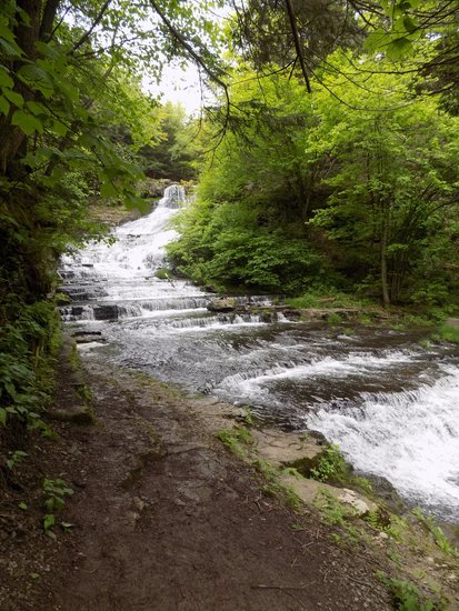
— Photo by Mike Nardacci
The impressive Rensselaerville Falls formed when Ten-Mile Creek cut a canyon into shale and sandstone layers, following an ancient fault line.
There are places in the world and within the United States in which layers of rock — called strata — record hundreds of millions of years of Earth’s history and are stacked atop one another like textbooks in geology, waiting to be read by the geologically literate. Undoubtedly the most famous is the Grand Canyon into which trails descend, traversing around 2 billion years of our planet’s past along paths less than 10 miles in length.
In Albany County, Route 85 departs Interstate 90 and heads southwest, terminating in the historic village of Rensselaerville and as it skirts Albany and rises into the fastness of the Helderbergs it yields evidence of the last great Ice Age, the collision of continents that formed the Appalachian Mountains, and of the proliferation of ancient life-forms during the Devonian Period, straddling 450 million years of geologic time in 30 scenic miles.
This essay presents a guide to some of the most notable features in a drive that, even allowing for stops, can easily be undertaken in an afternoon — preferably on a clear one so that the occasional stunning long-distance views will not be obscured by our area’s notoriously unpredictable weather, which seems to have been especially fickle in recent weeks.
Setting the odometer at “0” as one’s vehicle leaves Interstate 90 onto Route 85 — for the next few miles a divided highway — one will almost immediately be passing by the extensive complex of New York State office buildings that rise between Washington and Western avenues and farther to the west the towers of the University at Albany will be visible.
The buildings are constructed on a thick layer of sand that is conducive to the growth of pitch pines and earned the area the name “Pine Hills.” What most of the area’s residents are undoubtedly not aware of is the fact that some 10,000 years ago this stretch was lake-front property.
The last great advance of the Pleistocene glaciers ended about 20,000 years ago and after a brief stasis the great melting began as Earth underwent an extended period of warming. Just as no one is sure why the Ice Ages occurred (aside from the general fact that Earth got colder), scientists are unsure what caused the steep and steady rise in temperatures. But rise they did and, due to the warming, the Mohawk and Hudson rivers carried vastly greater amounts of water than they do now.
For reasons also unknown, a blockage occurred in the Hudson Valley somewhere south of Kingston forming a great body of water known as Glacial Lake Albany that filled the valley from the natural dam clear up to Lake George.
Many of the hundreds of streams that fed into the lake formed sandy deltas that combined to form one great shoreline upon which the Adirondack Northway and Route 9 roll north — and upon which this stretch of Route 85 heads southwest. Subsequently, the wind blew the sand into vast dunes and the crescent-moon shape of some of them can still be seen in the parts of the Pine Bush Preserve.

A "restored" section of the Pine Bush Preserve gives an approximation of the appearance of the area following the melting of the glaciers some 12,000 years ago when the stretch was part of the shoreline of Glacial Lake Albany.
Over time, great forests of pitch pine and patches of scrub oak and blueberry grew among them. Parts of the preserve that are undergoing restoration give an idea of the appearance of the sandy stretches thousands of years ago. But given Mother Nature’s prolific ability to reclaim empty growing spaces it will be interesting to see how long the areas currently being “restored” through the cutting of thousands of invasive species such as black locust trees will retain their resemblance to the ancient wind-swept dunes.
Areas “restored” only a few years ago already are green with great quantities of invasive plants, hiding the dune fields under newly-grown foliage. Ecologists call areas such as these “pine barrens,” and the sandy expanses stretching north from Albany County in many ways resemble the great barrens of New Jersey.
Farther to the east was the lake bottom upon which the smaller sediments carried by the streams were deposited, and this is why much of the city and in particular downtown Albany are built on massive layers of clay. In the 1800s and early 1900s, foundries used the clay to make bricks — hence the explanation for why so many older buildings in downtown Albany and Troy are constructed from them.
The extensive areas of both clay and sand in most places obscure the bedrock that lies buried deeply beneath them. It is a dark, thin-bedded shale that dates from the Ordovician Period, making it about 450 million years old. It is visible in a few outcrops bordering the Hudson River. One such outcrop is exposed on both sides of Interstate 90 as it descends toward the Hudson and passes under Henry Johnson Boulevard.

The Upper Gorge of the Onesquethaw Creek shows where the creek has cut deeply into layers of Devonian-age shales and sandstones.
At mile 4.0, Route 85 crosses the Normanskill where the stream slices through the dunes as it flows toward the Hudson. Some years ago, it undercut its sandy banks setting off a massive landslide in this area, causing the stream to permanently re-route itself.
After another couple of miles and several roundabouts, Route 85 joins New Scotland Road and between miles 5 and 6 passes through the historic stretch of Slingerlands reminiscent of New England. The terrain beyond here is mostly flat, rising gently to the west and represents what must have been relatively shallow waters of Glacial Lake Albany.
Geologists estimate that the shoreline extended roughly to what is now the intersection of routes 85 and 85A at the Stonewell Shopping plaza in the town of New Scotland.

Helderberg Country
It is at this point that Route 85 enters what I have always thought of as “Helderberg Country”: a landscape of agricultural fields, deciduous forests, scattered tiny villages, craggy outcrops of bedrock, and sweeping views of the massive escarpments.
Beyond the intersection of routes 85 and 85A, the surface material is a mixture of soils such as clay and sand and larger particles: semi-rounded pebbles, cobbles, and boulders, many of them eroded from bedrock tens or hundreds of miles to the north. Geologists call sediments such as these “glacial drift.” They were deposited directly by the great mass of glacial ice that buried this area thousands of feet deep at the height of the last advance, some 20,000 years ago.
At 8.2 miles, Route 85 passes the historic New Scotland Presbyterian Church, the cemetery of which entombs Winifred Goldring who in the first half of the 20th Century was the New York State Paleontologist; her meticulously-researched publication, “The Geology of the Berne Quadrangle,” with its accompanying beautifully-drawn stratigraphic map has long been a valuable resource for students of Helderberg geology.
At mile 10.7, Route 85 passes the site of the old Indian Ladder Drive-In Theater with its miniature golf course — gone these many years — and offers, in clear weather, an enticing view of the Helderberg escarpment stretching to the north. Shortly beyond the site, there is an exposure of bedrock in a road-cut on the left side of the road; in much of this area north and south of Route 85, these alternating layers of Ordovician-age shale and sandstone known as the “Indian Ladder Beds” are obscured beneath glacial drift or heaps of stone called “talus” eroded from the cliffs of the escarpment.
At mile 11.5, after passing through the hamlet of New Salem, the highway begins the steep ascent that takes it from one Landscape Region — the Hudson-Mohawk Lowlands — to another, the Allegheny Plateau.
Considering the shortness and steepness of the ascent, this is one of the most dramatic changes in landscape regions in the continental United States.
Though the region is locally called the Helderberg Mountains, geologists see it as well as the Catskills to the south as a vast eroded plateau, given that the rock layers that compose it are relatively horizontal and undeformed (except for some minor faulting visible in many areas in Albany County).
The great Allegheny Plateau — also known as the Appalachian — stretches from just west of Altamont south to Alabama and it was formed during the Alleghanian Orogeny; this was an episode of mountain-building that occurred around 290 million years ago, when the ancient landmass that would someday be known as Africa collided with ancient North America.
For a simplified visualization of this event, think of what happens when two cars in a parking lot crash into each other nose-to-nose: The hoods and engine blocks of the cars may be crushed and compacted and pushed upwards, but the rear parts of the cars may be only slightly warped and lifted up above the chassis.
During the Alleghanian Orogeny, the area to the east of us was crushed and elevated into the great chain of mountains that stretches south from New England. The rock within was folded, faulted, raised to great heights, and in many places turned into metamorphic rock; the land farther west was elevated but remained largely undeformed and became the Allegheny (or Appalachian) Plateau.

At the top of the hill, Route 157 cuts right and heads toward Thacher Park. Route 85 continues along a flat lower section of the plateau, offering on clear days broad views across and up the Hudson Valley to three mountain ranges: in the far north, the Adirondacks near Lake George; to the northeast, the Green Mountains in Vermont; and to the east, the Berkshires in Massachusetts — these latter two are actually the same range with different names. Farther to the south in New York State, they are known as the Taconics.
Following the westward curve of the landscape contours, the road passes outcrops of dark shale before descending slightly to the wide valley of the Onesquethaw Creek at 13.7 miles. In the creek bed is exposed the Onondaga limestone, the uppermost layer of limestone in the Helderberg area.
The Onesquethaw drains nearby Helderberg Lake, but in dry times of the year it may flow invisibly under the heavily-fissured rocky creek bed as the Onondaga limestone is a major former of caves. The nearby Clarksville Cave and Onesquethaw Cave among many others are dissolved from the Onondaga.
Devonian-period fossils
In times of rapid snowmelt or unusually heavy precipitation, the creek flows above ground, forming swirling rapids in this stretch. A clean light-gray limestone formed in a long-vanished warm, tropical sea, the Onondaga is studded with beautifully-preserved Devonian-period fossils including numerous corals and shellfish.
Beyond the creek bed, Route 85 briefly joins Route 443 and heads on a shoulder of the valley steeply uphill. Here the bedrock consists of alternating beds of thinly-bedded shale and thick layers of dark sandstone, and these strata extend south through the Catskills.
While the lower-elevation layers exhibit marine fossils — trilobites and clam-like brachiopods, among others — the higher-elevation layers near Gilboa and elsewhere south of the Helderbergs show fossils of primitive land plants and giant fern trees that obviously grew above water.
These layers are the eroded remains of what geologists term the “Catskill Delta.” The name is somewhat misleading for there were numerous deltas that formed and co-joined during the Acadian Orogeny, a period of mountain formation that occurred during the late Devonian Period as North America collided with that section of the primitive European continent known to geologists as Avalon.
Towering, snow-capped mountains rose that were as grand in their day as the Rockies. Rushing streams poured from their flanks, carrying heavy loads of dark sand, clay, and mud, filling in the shallow sea in which the Onondaga limestone formed and producing deposits thousands of feet thick that would eventually be elevated by tectonic action into the Allegheny Plateau.
There are numerous outcrops visible in the Helderbergs in which the dark shale layers sit directly atop the light-gray limestone — compelling evidence of the rise of the great mountains to the northeast.
At 15.8 miles, there is a pull-off on the right side of the highway allowing a glimpse into the deep gorge that the Onesquethaw Creek has formed at the south end of Helderberg Lake. A mini-version of Ausable Chasm, the gorge features rapids, waterfalls, plunge pools, and numerous traces of the movement of small faults and the folding of the rock layers that probably occurred during the Alleghanian Orogeny.
In the gorge, the Onesquethaw Creek provides an example of what geologists call an “under-fit” stream. The deep gorge shows signs of having been eroded by a stream with far more power than the Onesquethaw shows today, but at the time of the melting of the glaciers the ancient Onesquethaw must have been a veritable torrent and its surging, sediment-laden waters would have had sufficient energy to cut deeply into the bedrock, forming the steep-walled canyon visible today. It should be noted however that the gorge is on private property and permission from its landowners must be secured for entry.
At 16.4 miles, there is a view of privately-owned Helderberg Lake to the right of the highway; to the left are road-cuts through the shale/sandstone strata showing their thin layering and fragmentation.
Shortly beyond this point, Route 443 veers west toward Schoharie and Route 85 continues in a southwest direction, moving into a region of fields and forests. Meandering across the landscape are numerous stone walls made both of flat, angular chunks of the local stone and occasional smoothed or rounded boulders; these are “glacial erratics” — transported sometimes hundreds of miles from the Adirondacks or even Canada by the ancient glaciers and shaped by grinding against other rocks in the ice or in the streams that poured from the glaciers in summer.
Robert Frost found these rocks annoying in his famous poem “Mending Wall” as their rounded shapes make them resistant to stacking and easily susceptible to the pull of gravity. The fields here as in the town of New Scotland are buried deeply in glacial drift; clearing these fields first of trees and then of the larger rocks in the soil for farming in the days of the pioneers must have been an appalling challenge.
At mile 24.4, a high glacially-sculpted hill appears prominently on the left side of the road. Like Bennett and Countryman hills near Clarksville, it exhibits a fairly steep north face, a flattened top, and a long, gentle slope to its south face — features of what geologists call a “rock drumlin.”
Fantastical village
At mile 26.9, Route 85 terminates at a T-intersection in the hamlet of Rensselaerville, a diminutive hamlet that very few residents of the city of Albany seem to be aware of — and those who have heard the name almost inevitably confuse it with the city of Rensselaer.
With its steeply sloping streets, its historic buildings, churches, and cemetery, its tiny art gallery and elegant eatery, and the town-wide echo of flowing water from Ten-Mile Creek, the hamlet’s ambience evokes that of Harper’s Ferry in West Virginia — or to the more romantic-minded, the fantastical village of Brigadoon.
Taking a right at the T-intersection and ascending steeply to the west end of the village past the restored mill, one soon enters the Huyck Preserve.
The Preserve consists of over 2,000 acres of forest and includes Lake Myosotis, a wilderness lake that can be accessed both by foot or by car. A trail begins at the west end of the small parking lot and heads upstream along Tenmile Creek.
Almost at once, hikers will hear the sound of falling water. The trail crosses a bridge near the mossy ruins of a 19th-Century mill and offers the first tantalizing view of the Rensselaerville Falls. Just beyond the bridge, a trail cuts sharply to the right and upward and follows a somewhat exposed ledge.
The trail is comfortably wide here though to the right there is a drop ranging between 20 and 30 feet down to the water and hikers should proceed with care. After a couple of hundred feet, one arrives at a ledge approximately one-third of the way above the base of the falls, offering a stunning view of the waterfall.
Here the thin-bedded shale and massive sandstone layers have been incised by Tenmile Creek following a fault that has sliced through the rock layers creating a box canyon into which the overflow from Myosotis Lake plunges 125 feet down a series of step-like projections. The erosive effects of water and ice have caused large, angular boulders to break from the bedrock, creating lacy meanderings and cascades for the rushing waters.
At the bottom of the falls is a plunge pool bordered by flat shelves of the dark shale, and a sharp-eyed observer may see in some of the exposures wide ripple marks: evidence of the shallowing of the ancient waters in which the sediments were deposited by streams rushing from the high mountains rising to the northeast during the Acadian Orogeny.
Soon those deposits would form the so-called Catskill Delta on which primitive ancient plants including fern trees would grow. Millions of years later, the violent events associated with the Alleghanian Orogeny would elevate the layers far above sea level and perhaps cause the fault through which Tenmile Creek would begin its spectacular plunge toward the sea.
I have always taught my students that, to appreciate geologic history, one must have a good imagination. Driving on Route 85, one begins on the sands of the immense delta that bordered Glacial Lake Albany some 10,000 years ago — a time which, to a geologist, is not much further back than yesterday morning.
But along the highway lies evidence of ancient seas, the rise and fall of great mountain chains, the effects of millions of years of weathering and erosion, and the more recent, Earth-altering events of the last great Ice Age. There are few places in the continental United States where so much geologic history is revealed — and so easily accessible. For those with the inclination and imagination, the chronicles of worlds forever lost and gone lie almost literally in our backyard.
Location:
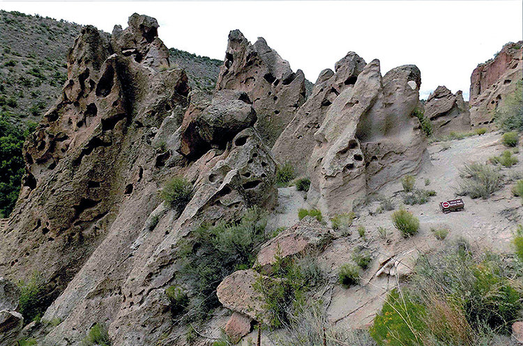
— Photo by Mike Nardacci
Eroded pinnacles of the volcanic rock known as “tuff” tower above the valley of Frijoles Creek in Bandelier National Monument. Within and around the grottoes in the rock, the ancient Anasazi people stored food and carved out living spaces.
Scattered across the Southwestern states of the United States are the remnants of an ancient civilization as mysterious in its own way as that of the Etruscans or the Minoans. Evidence of the rising culture of the people long known as the Anasazi appears over 2000 years ago and reaches its highest stages of development in the 1200s A.D.
They are the ancestors of today’s Pueblo-dwelling people, and visitors to the modern-day villages at Taos or Acoma in New Mexico will see the resemblance of the ruins of the ancient people’s cliff-dwellings and free-standing buildings to modern Pueblo dwellings. Developed archeological sites easily accessible to visitors include Mesa Verde and Chaco Canyon, but other known ancient sites number in the tens of thousands, and no one can be sure how many more have yet to be discovered.
The beauty and ingenuity of construction of the dwellings and religious structures of the Anasazi are legendary, existing as they do in some of the driest, hottest, least inhospitable parts of the country — places that frequently resemble the arid, rocky landscapes being explored by robots on Mars. Inevitably, questions arise about why these people chose such places to live and how they were able to find sufficient food and water to survive.
More frustrating is the fact that the Anasazi did not have a written language and the many petroglyphs (carvings on rock faces) they left behind are both beautiful and tantalizingly abstract. They seem to depict a culture in which a spirit world and the material world existed side by side and frequently interacted. Perhaps none of the mysteries the ruins evoke is as profound as what appears to have been the sudden and possibly violent end to the Anasazi culture.
The first archaeologists to explore at Anasazi sites such as Mesa Verde found dwellings from which the inhabitants appeared literally to have grabbed what they could carry and fled — often leaving behind clothing, beautifully-crafted pottery, and partially-eaten meals on tables. If these discoveries seem comparable to similar findings at Pompeii, the cases are not in any other way parallel.
In the Southwest, there is no evidence of a sudden natural disaster such as a series of volcanic eruptions. Although an extended drought occurred in the 1200s, such events had occurred before and the ancient people had managed ingenious methods to survive them. In addition, objects too heavy to carry — such as stones for grinding corn — were often smashed to prevent anyone else from using them, strong indications that the sites were abandoned suddenly and under duress.
Archeological wonder
Located a few dozen miles northwest of Santa Fe, New Mexico, Bandelier National Monument is one of the archeological wonders of the American Southwest. The site was first explored (and subsequently named for) Adolph Bandelier, an anthropologist of Swiss-American extraction.
It is situated where a clear stream known as Frijoles Creek that flows year around — a rarity in this arid region of New Mexico — has cut deeply through the surrounding plateau forming a craggy hidden valley. From time to time, the stream overflows its banks and, when it returns to its bed, it leaves behind — like the Nile River — a layer of rich soil.
Both on the creek’s floodplain and in the cliffs that tower above it are some amazing remnants of dwelling places of the ancient people. The floor of the valley is green and fertile and the remains of free-standing pueblos and walled gardens can be seen there today. But it is in the vertiginous cliffs that the handiwork of the ancients is most spectacular.
Here are artificial caves carved into the bedrock accessed by ladders or precipitous stairways that meander through crevices eroded into the bedrock forming natural windows and grottos. There are also homes and storage places built ingeniously into the bedrock, sometimes in harrowingly precipitous locations.

It is of course tempting to see these structures as having been built in such spots for protection — but it is also possible they were situated there for the same reason that modern people buy condos in high rises: The views are great!
The bedrock at Bandelier, hundreds of feet thick, is an igneous rock called “tuff” — not to be confused (as even some geologists have been known to do) with “tufa,” which is a chemical sedimentary rock often found at springs and seeps in areas of limestone bedrock. Composed of very light-colored dust and sand-sized particles and tiny sparkling quartz crystals as well as larger, angular pebble or cobble-sized rock fragments, the Bandelier tuff formed from the compaction of materials blown out of a gigantic volcanic eruption that occurred near Jemez Springs, New Mexico, over a million years ago leaving the giant collapse feature known as the Valles Caldera.
Though the caldera is quiet today, hot springs around its perimeter and occasional earthquakes indicate that — just as at Yellowstone National Park — a great pool of magma lies beneath the surface and could erupt again.

The great advantage of the tuff into which Frijoles Creek has carved its deep canyon is that the stone is relatively soft, and with the primitive tools available to the Anasazi people it was possible both to hollow out the shallow caves that were carved into the canyon walls and to shape blocks from which the free-standing buildings in the valley were constructed.
The blocks were also used to build walls and terraces surrounding gardens on the green, well-watered valley floor in which the ancients grew their staple crops of corn, beans, and squash. The plateaus above the valley were rich in game — there were herds of elk providing meat and hides, flocks of turkeys, rabbits, and other wildlife that could be used for food or clothing.

An ideal place to live
In sum, Bandelier was an ideal place to live, especially when compared to many of the other ancient settlements such as Mesa Verde, Chaco Canyon, and hundreds of other sites that show the ingenuity of the ancient people in adapting to appalling geographic and climate conditions but were hardly ideal places to live.
In addition to having a moderate climate, Bandelier was largely hidden from the view of passers-by, it was sheltered from storms, it could be easily defended if necessary, and it had a well-watered, fertile space for growing crops. So the question naturally arises: What made the ancient people abandon such an ideal location, supposedly to vanish into history?
Well, to start with: The romantic notion that the Anasazi simply vanished, like Attila the Hun and his hordes after Attila’s legendary meeting with Pope Leo I, is simply incorrect. The Pueblo people today whose villages are scattered widely across the Southwest are the direct descendants of the Anasazi, and their oral traditions frequently pinpoint specific locations even down to individual ancient pueblo sites as their places of origin.

The appearance of a dwelling in a modern-day village such as the Santa Clara Pueblo near Santa Fe, New Mexico shows the direct influence of the heritage of the ancient Anasazi: their astoundingly beautiful pottery; the multi-levelled dwellings with upper homes accessed by ladders; the starkly beautiful simplicity of design; and the ubiquitous “horno” — outdoor oven — around which meals are prepared and family and friends will gather.
But the fact remains that something of staggering impact occurred during the mid- to late-1200s A.D. causing the ancient people to evacuate their dwellings on exceedingly short notice and to take whatever they could carry, destroy much of what they could not, and flee to the south, resettling in the areas in which their descendants live today.
Disturbing factors
Once the lack of persuasive evidence that the migration was caused by drought or other natural disasters is taken into account, other sometimes disturbing factors must be considered. Recent archaeological digs in sites such as Chaco Canyon have found strong evidence of ritual cannibalism and violent warfare, adding an unsettling note to the romanticized depiction of the ancients living in blissful harmony with other tribes and their natural surroundings.
Moreover, even the term “Anasazi” has come to be considered politically charged in many quarters. Derived from a Navajo word, “Anasazi” may be translated as the benign expression “ancient ancestors” — but it may also be read as “ancient enemy.” This ambiguity has come to be regarded as explosive and in scholarly literature today is frequently replaced by the neutral expression “ancestral pueblo people.”
However — it has been duly noted by serious historians that the people of ancient cultures did not live their lives for the approval of those of us living in the 21st Century and we cannot impose our values in interpreting ancient clues, even if those clues lead us to unpalatable conclusions.
Whatever our admiration for the accomplishments of the Anasazi, whatever our trepidation over evidence of violent behavior that may emerge, one simple fact remains: These people did not write history books or carve inscriptions on their monumental works.
The reasons that they fled from such ideal sites as Bandelier and sometimes left behind evidence hinting at dire events will likely never be known, and explanations in oral traditions are ambiguous and sometimes contradictory.
But in thousands of sites such as Bandelier, Mesa Verde, and Chaco Canyon we may see their artful, ingeniously constructed stone works, their exquisitely painted pottery, and their haunting petroglyphs, all of them evoking a world about which we know far little than we would like but within which we can see both glimmers of the creativity of the human spirit and shadows of the dark events of our own sometimes violent past.