
The Enterprise — Michael Nardacci
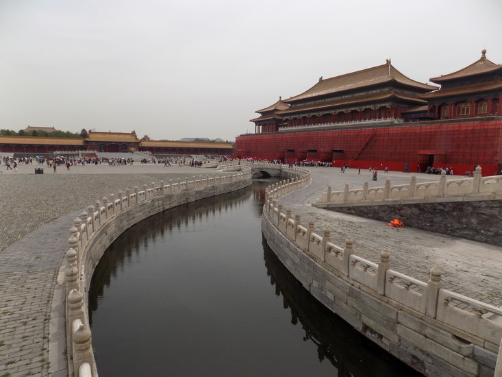
The classic view of the ethereal central temple of Angkor Wat is reflected in the surrounding moat. The temple’s walls and towers show scars of the chaos under the Khmer Rouge.
The classic view of the central temple of Angkor Wat is from the bank of the surrounding moat. When a gentle breeze stirs the water into tiny wavelets, the reflection of the temple’s five towers against scattered clouds in the mild Cambodian sky looks like a pointillist painting, with splashes of white and blue and gray and brown producing an image that might have come from the palette of Georges Seurat; when the surface of the water is mirror-smooth, usually at dawn or dusk, low sunlight softly illuminates the looming lotus-shaped towers or silhouettes them against the multi-colored western sky, creating a scene out of an ancient Khmer epic and its perfect inverted image.
But Angkor Wat is only one of hundreds of beautiful structures built by the kings of the ancient Khmer Empire. With the nightmare of the rule of the murdering Khmer Rouge over, archeologists and artisans are today back at work, restoring many of the structures and retrieving dozens more from the choking jungles — which, ironically, have in many cases saved the temples from collapse.
Unlike the great buildings of many other ancient civilizations — the granite and quartzite monuments of ancient Egypt; the marble beauties of the Parthenon and other structures on the Acropolis in Athens; the astounding achievements in concrete and brick of the ancient Romans — Angkor Wat and the many other temples and royal pavilions were constructed from one of the humblest of sedimentary rocks: sandstone.
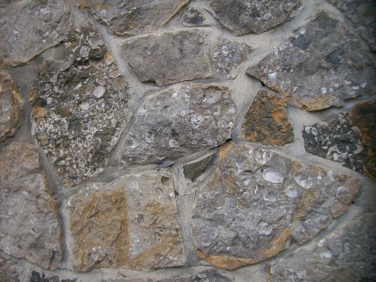
The term “sandstone” is generic because technically any type of rock can be reduced to sand-grain-sized particles and then cemented together to form rock. But the term usually refers to rock composed of silica sand — the sand found on many of the beaches and in many of the dunes of the Earth. In some places, the silica is mixed with shell fragments of many sizes, producing “calcareous sandstone,” which weathers in natural acids just as limestone, marble, and gypsum will.

But the sandstone of Cambodia’s Kulen Mountains from which the Angor temples are constructed is essentially pure silica, which does not easily weather chemically, and, given the often extremely humid climate conditions of Cambodia, is undoubtedly the reason that the Angkor temples have survived relatively intact for so many centuries. Had they been built from limestone or marble, the natural acids of the environment and the entangling vines would almost certainly have erased the many delicate architectural and sculptural features of the temples, leaving behind only sad, stubby remnants protruding from the lush jungle floor.
The earliest of the temples were constructed in the 10th Century by the first kings of what would eventually emerge as the ancient Hindu Khmer Empire, men with melodious names such as Jayavarman, Harshavarman, and Suryavarman. Unlike the great temples of many Western civilizations, these Hindu religious structures were not intended as gathering places for worship by the faithful but as residences for the gods of the Hindu pantheon.
In this function, they exhibit some similarities to many ancient Egyptian temples. Only the attending priests entered a temple’s inner sanctum and worshippers would gather outside the building’s walls for prayers and rituals. Thus, the temples’ architects did not have to solve the challenges of constructing and covering immense gathering spaces such as are found in Christian basilicas, Islamic mosques, and Jewish synagogues.
As a result, the temples’ interiors are dimly-lighted and maze-like, with long corridors, steep ascending and descending staircases, and small, often diminutive chapels in which statues of Hindu gods and goddesses — and somewhat more recent depictions of the Buddha — reside in the incensed gloom. Both interior and exterior walls are covered with thousands of square feet of beautifully detailed carved figures from the Hindu pantheon and with the enchanting “apsaras,” the winsome dancing maidens with smiles as enigmatic as that of the Mona Lisa.
A few miles from the main temple at Angkor stands a small temple known as Banteay Srei, and though unlike Angkor Wat it does not seek to overwhelm the visitor with vastness and mass, it leaves its impression though the astounding delicacy and intricacy of its carvings. It is familiarly known as “the Citadel of Women” because of its numerous carvings of Hindu goddesses and the ubiquitous “apsaras.”
Perhaps because nowhere do its many chapels stand more than 30 feet in height and the fact that until fairly recently the temple was protected by the vines and tree trunks of the enfolding jungle, the intricate, filigree-like carvings that seem to cover every square foot of the exterior and interior of the structures are preserved in stunning detail. Here the hard Kulen Mountains sandstone has retained much of its original cinnamon-red color.
To wander through its open-air maze-like layout is to enter a fantastic world of goddesses and other figures out of the Hindu pantheon, alluring or sometimes frightening fantastical animal-headed humanoids, juxtaposed with delicately-depicted trees and flowers.
The Bayon
Closer to the central area of Angkor Wat is the great temple known as The Bayon, which the French archeologist and restorer Bernard Phillippe Groslier has called “the most amazing piece of architecture in existence.” It was constructed by King Jayavarman VII at the end of the 12th Century A.D. at which time the Khmer kings had briefly converted to Buddhism, and The Bayon shows the influence of both religions, though the Buddhist images dominate.
It is not as well preserved as some of the other Khmer temples; it seems to have been somewhat hastily constructed. Consequently it has not weathered the centuries so well. Nonetheless, even in its mildly dilapidated state, it captures the imagination as perhaps no other building on Earth.
The Bayon rises out of the jungle on a series of stone platforms in what a tourist guide describes as “a stone mountain of ascending peaks” capped by 37 towers, though archeologists speculate there may have once been as many as 20 more. The looming towers are built of layer upon layer of gigantic stone blocks, and each exposed side of the blocks features a carving of the face of the Buddha — or, perhaps, the face is that of Jayavarman VII himself, depicted with his eyes closed in meditation and with the Buddha’s mystical smile.
The visitor tries in vain to count the dozens — then, hundreds — of faces of various sizes and states of preservation, aimed at the four major points of the compass. The fact that some of the faces are only partially preserved — a disembodied smile here, an ear or eyes on an eroded face there — makes the scene all the more mysterious and alluring.
The temple has the same darkened interior maze of corridors, staircases, chapels, and dungeons of many of the other Angkor temples. But the mysteriously smiling faces never suggest danger, even when one is ascending or descending one of the dizzyingly steep flights of stairs or is momentarily disoriented in one of the decorated corridors.
Rather, the general impression is one of peace and connection with the infinite among the smiling visages on the towers reaching toward the sky. As in Angor Wat, everywhere is the odor of incense, and at any turn a visitor may come unexpectedly upon a statue of the Buddha draped in a saffron-colored robe, bedecked with brightly-colored flowers and fruits. From an unseen source may come the tinkle of copper bells or the chanting of monks: the effect is of a Buddhist mantra become tangible.
Ta Prohm
Besides Angkor Wat itself, the temple known as Ta Prohm is perhaps the most familiar to Western eyes as its setting irresistibly evokes the romantic spirit of the Indiana Jones epics. Situated a few miles from Angkor Wat, Ta Prohm retains — by deliberate design of the archeologists — much of the appearance of the entire vast temple complex when it first came to the attention of Western explorers in the late 1800s. Its extensive staircases, courtyards, chapels, and hallways have been left to a large extent wrapped in the huge above-ground roots of immense Silk Cotton trees and the smaller vines of the strangler fig. And therein lies a paradox.
While the process known as “root-wedging” is one of the most efficient methods of breaking down rock — many of us have seen our sidewalks and driveways damaged or even destroyed by the roots of trees that get under or between concrete surfaces — the giant roots of the engulfing tropical trees at Ta Prohm and scores of the other ancient Khmer temples have held its immense carved sandstone blocks in place.
As many of the other temples were restored, the huge encasing roots were removed and any stones that had been displaced were returned to their original positions and secured with mortar. But at Ta Prohm, the visitor gets a sense of what it was that the first explorers saw when they trudged through the steamy jungle and laid eyes on the spectacular remnants of the ancient Khmer kingdoms.
The serpentine appearance of the huge roots and vines adds immeasurably to the haunting lure of the mazes of the temple’s interior and, where they hang suspended or wrap around the statue of a Hindu deity or a frieze of dancing “apsaras,” they evoke awareness of the passage of eons and hint at the glories of lost civilizations.
One wall carving that is not obscured by the huge trees presents a mystery that has provoked controversy from the day of its discovery, but it is well known to the local guides — some of whom are children who have played hooky from school and scurry about the temple, hoping to pick up tips from tourists for showing them what the kids call the “dee-no-soo”: a stunningly accurate depiction of the dinosaur known as a Stegosaurus, triangular back-plates and all.
Given the fact that the critter has been extinct for at least 66 million years, is this carving simply an amazing coincidence — depicting some hitherto unknown figure out of Hindu mythology? Or is it conceivable that some ancient Khmer sculptor had seen an almost-intact fossil of the beast or heard accounts of it from someone who had?
Needless to say — the accuracy of the carving and its mystical location have produced all kinds of so-called “non-mainstream” theories about its origin of the kind presented all too frequently on cable TV. It represents one more of the conundrums that the Angkor temples present.
Reign of terror
Sadly, visitors to the temples also learn of history that is much more recent than the annals of the Khmer kingdoms. On the walls of many of the temples — and very obvious at Angkor Wat itself — are ugly, shallow holes: the scars of bullets that bespeak the reign of terror of the Khmer Rouge, the Marxist thugs who took control of Cambodia while the Vietnam War raged to the country’s east.
At first welcomed by the United States and its allies as a buffer against the Viet Cong, the Khmer Rouge regime under Pol Pot set up a dictatorship that even by the standards of 20th-Century atrocities is remarkable for its truly demonic savagery. Horrifying evidence of the brutality is provided by the many beggars who haunt the ruins, often missing limbs or eyes.
At first, the Khmer Rouge forced its utopian plans for a pure Marxist state in Cambodia on the country’s peasants and intellectuals and former rulers, but the revolution soon turned inward as so many revolutions do and began killing its own members whose dedication was not regarded as “pure” enough. Two million Cambodians died in the resulting slaughter, and though both the Khmer Rouge and the intruding Viet Cong called themselves Communist, their struggles for power were sometimes fought right within the Angor temples as control of the great buildings was held to be symbolic of political power.
Statues were beheaded and carvings were torn from walls and the beautiful artworks of the ancient Khmer were sold on the black market to raise money for Pol Pot’s draconian schemes. Miraculously, many have since been recovered and some have already been replaced — but the scars left upon the temples fade slowly as do the memories of the gentle people of Cambodia who lived through the Khmer Rouge nightmare.
The temples today rise like dreams from the misty jungle, their restored beauty and grace testament, perhaps, to the vitality and resilience of the human spirit. But the scars of conflict that pepper the delicate towers and the intricate carvings also offer validation to the fact that, throughout human history, attempts to use force to bring about a worldly paradise have usually resulted instead in the creation of hell on Earth.
Location:

The Enterprise — Mike Nardacci
A view of the 7,000 terra-cotta figures uncovered by Chinese archaeologists. The hangar which covers the pit in which they were discovered is over twice the length of a football field.
Located in northwestern China, the great city of Xi’an — pronounced “she-ahn” — like hundreds of other cities in China, exhibits an exhilarating mixture of ancient and modern.
In former times, marking the eastern end of the Silk Road, the city boasts hundreds of super-modernistic office buildings and apartment towers, though many stand empty — the result of China’s desire to put to work as many people as possible, without considering the fact that many of its citizens either cannot afford these high-rise digs or simply have no desire to live 50 stories above the ground. From a distance, modern Xi’an may look like a backdrop for a scene from a Star Wars episode — especially at night, when great numbers of the buildings feature light shows that out-do Times Square at New Year’s Eve.
But surrounding the central part of the city is a great wall — not the Great Wall, but a massive fortification nonetheless — built during the Ming Dynasty in the 1400s, which is a powerful reminder of Xi’an’s history. Starting around 250 B.C., Xi’an became the capital of China under Qin, the country’s first Emperor. Qin had conquered the other kingdoms that lay within the landmass known today as China, though evidence suggests that there was continued and often violent resistance to Qin’s autocratic and self-indulgent rule.
Guarded by jutting towers and with a scattering of beautiful Buddhist shrines situated strategically on its extensive esplanade, the wall protects what was once the central part of the ancient capital. Hundreds of crimson lanterns — lighted at night — hang from golden posts along the wall and sway in the wind, seeming to celebrate the new (if still limited) freedom that has come to China.
Today Xi’an has expanded far beyond the area enclosed by the wall and out onto the vast Plain of Guanzhong that surrounds the city and is dotted with shrines and tombs of Qin and the other emperors who dwelt here during the early years of united China’s turbulent history.
The Plain of Ganzhong covers hundreds of square miles and is formed by the conjoined floodplains of the great Wei River and seven other rivers and streams. Floodplains by definition are subject to disastrous overflows and in modern times a system of dams and levees protects the city. But over millennia, repeated massive flooding of the rivers has left thick deposits of clay and silt covering Ganzhong, which has now been left high and dry as a result of a dropping water table.
Aware of his own mortality, Emperor Qin made a bold decision — one on a par with the great pharaohs of Egypt such as Djoser, Khufu, Seti I, Ramses II: He directed his subjects to build for him a massive tomb, surpassing in size and grandeur the tombs of all of the petty warlords whom he had defeated in his quest to unite China under a single power: himself.
Thus, some miles from the city of Xi’an there arose on the Plain of Ganzhong an enormous tomb whose location is precisely known: Looking like a low, gentle hill, it stands covered in soil and foliage, visible for miles. But legends of its contents have cautioned archaeologists to put off opening it, as the current state of archaeological science may not be up to meeting its challenges. And so there the great mound stood for years, while around it, farmers went about their business.
Until 1974.
In that year, a farmer and some helpers were hand-digging a well, working their way down through the thick sand and clay sediments. They were down only a few yards when fragments of ancient bronze spears and pottery began to turn up; had they dug only a few feet in a different direction they would have missed them completely.
The diggers notified government archaeologists who continued excavating and soon made a stunning discovery: a life-sized terra-cotta head staring at them from out of the muck. Continued careful digging revealed that the entire body of the figure attired in minute detail as a warrior was there as well, albeit in fragments requiring reconstruction.
To call this discovery “the tip of an iceberg” would be a colossal understatement. For as excavations continued, more full-sized terra-cotta warriors began to turn up, first by tens, then by hundreds, and eventually by the thousands. Today they number over 7,000 and are displayed in a vast hangar the length of two football fields that covers the yawning pit in which they stand in 1000-foot-long phalanxes, appearing as though they are awaiting marching orders.
Each was attired differently from his companions and each was apparently an individual portrait of a foot-soldier. Most of the figures had been shattered in ancient times and required careful reconstruction, the result of the upheavals that followed the death of Emperor Qin in which rebellious subjects vented their anger against Qin’s extravagance.
In recent years, two additional pits have been opened, containing life-sized horses in battle gear and chariots along with soldiers of higher rank — lieutenants and generals — as well as archers and spearmen: the elite of the Terra-Cotta Army of Emperor Qin.
The term “terra-cotta” is Italian and means simply “baked earth.” It is an extraordinarily inexpensive and common material: those reddish brown flower pots on your porch and patio are terra-cotta, and it is commonly used for pipes, roofing tiles, and bricks as well. It is derived from common clay, a material found everywhere water has been ponded.
Extensive deposits occur on flood plains — upon which much of the city of Albany stands — and they underlie large stretches of the Schoharie Valley as well. A quick glance at the enormous number of structures in these areas built from brick confirms the presence of great quantities of clay.
Terra-cotta has been used for artistic and building purposes from ancient times, and terra-cotta statues, tiles, pipes, and sarcophagi from all over the Mediterranean world show the material’s easy availability and adaptability. Sometimes the baked clay is glazed or painted, but more commonly it is left with its natural fired-appearance: the quintessential “earth-tone,” derived from the presence of iron compounds in the clay which oxidize during firing.
But then of course the question arises: Why on Earth is the vast terra-cotta army there at all?
The answer lies in the concept the early Chinese — as well as other ancient cultures — had of an afterlife. If cultures conceived of personal survival beyond the grave, many of them considered it simply an idealized form of the best of life on Earth.
Wall paintings in the tombs of such people as the ancient Egyptians and the Etruscans depicted the deceased happily indulging in many of the same activities of the living, though with far greater levels of enjoyment and productivity.
But some peoples like the ancient Egyptians also believed that the deceased might be called upon by the gods to work in their fields and vinyards, and to save the dead the exertion bodies were buried with wooden or faience figures called “ubshabti” — often by the hundreds — that were expected to come to life in the next world and take the place of the deceased in whatever work the gods dictated. Qin could immerse himself in an indulgent life-style in his palace in Xi’an with full expectation that following his death, the feasting would go on forever.
Yet from all evidence the court of Emperor Qin was also a place of internal political struggles — tales of attempted murders, poisonings, and forced suicides have come down through the years, undoubtedly embroidered upon as the passage of time will do. There were also constant military threats from the recently conquered provinces whose subdued inhabitants were not enthused about being part of Qin’s recently patched-together empire.
And of course, there must have been many malcontents under his rule who were unhappy to see the empire’s wealth being squandered on Qin’s extravagant whims at a time when — like today — many citizens lived in squalor. Thus when he planned his magnificent tomb, Qin apparently made the decision to see that it was well guarded against marauders from both inside and out.
And so in the flat stretches of land surrounding the tomb he had his artisans create his terra-cotta army, ready to spring to life should the god-like emperor’s rest be in jeopardy from enemies either outside or inside his kingdom.
What else may hide beneath the soil near Qin’s tomb and the tombs of other emperors that lie nearby — some with brutal reputations and tastes as luxuriant as Qin’s — remains unknown. More recent excavations have found the graves of large numbers of men and women who were interred at the same time as Qin and the horrifying evidence is that they were buried alive.
Perhaps they were captured enemies doomed to serve as slaves to Qin in the next world; perhaps they were to serve as companions to the dead emperor in the afterlife; or perhaps they were killed because they knew too much about the secrets that lay within and around Qin’s unexcavated tomb rising a mile or so from the pits of the terra-cotta army. How ironic that so much stunning artistry was created under circumstances that speak of so much misery.
And yet — and yet — to look at the hauntingly beautiful individual figures with every item of clothing and footwear rendered in exquisite detail is to come face-to-face with men long dead whose demeanor projects a startling calm and dignity. It may be that the look was mandated by the emperor’s undoubtedly intimidating control.
But perhaps the soldiers really believed that in having their likenesses preserved in terra-cotta — a humble material given the touch of glory — they could share Qin’s luxuriant after-life.
Location:
The Enterprise — Mike Nardacci
One of the immense Imperial courts in the Forbidden City in Beijing has not a flower, blade of grass, or tree to offer shade for visitors.
The Forbidden City in Beijing was for centuries the home of China’s emperors — an incredibly vast, luxurious series of courts, plazas, and spectacular imperial buildings, including throne halls, offices, and residences for the emperors’ families and courtesans. It was strictly off-limits to the ordinary people of China. Begun as the imperial residence during the Ming Dynasty in the early 1400s, the complex grew to contain approximately 1,000 buildings.
The structures are marvels of traditional Chinese colossal architecture: upturned roofs adorned with figures from Buddhist history and Chinese mythology, elaborately carved wooden walls and pillars painted Imperial red. Constructed without a single nail, they stand on broad platforms elevated well above ground level surrounded by moats crossed by ornate bridges.
Visitors pass through magnificent gates into vast courts, each seemingly more impressive than its predecessor. Many are decorated with beautifully rendered Chinese lettering, transmitting whatever message a particular emperor wished to convey, but the essence is communicated without any translation: Power, power, POWER.
It is no wonder that, when the Communists took control of China, Chairman Mao Zadong saw to it that his immense portrait adorned the entrance to the Forbidden City — an ironic statement of the fact that the “classless society” now had a “People’s Emperor” in residence.
Yet, especially on a hot summer’s day, one fact becomes glaringly apparent: Nowhere among the bridges, esplanades, or terraces is there a spot of green. There are no sculptured trees or displays of potted plants anywhere.
The giant structures bake in the glaring Beijing sun and, from early morning to late evening, there is scarcely a hint of a shady refuge, save for the immense gated doorways in the walls that divide one huge open court from another. According to the Forbidden City’s official guides, the reason had to do with security for the emperors and their families and other government officials: A tree could provide cover for an assassin, as could an elaborate flower bed.
Better that the ruling classes and those guests invited into the confines of the Forbidden City should see its buildings in all their unobstructed grandeur than risk some arboreal or floral beauty spot which could give cover to an enemy with murderous intentions.
But Chinese scroll paintings and artwork on vases have often depicted idealized landscapes in which craggy mountains wreathed in clouds rise above forests and in which delicately-portrayed trees and flowers and waterfalls emerge from the mist, sometimes with a solitary figure or two or a pagoda dwarfed by the natural beauty. Traditional Chinese art and poetry have frequently centered on nature’s ability to diminish humans and their handiwork while at the same time celebrating the mystical beauties of the landscape.
Thus, it is less a surprise than a stunning revelation to pass through the penultimate gateway in the Forbidden City and enter the twisting pathways of the Imperial Garden.
All at once, the trappings of overwhelming imperial power are gone. Instead, visitors find themselves in landscape from a Chinese fairy tale, a world of ancient trees, fantastic rock outcrops, waterfalls, and flowers, and scattered and hidden among them elaborately decorated gazebos.
Above the garden is an occasional view of one of the large imperial residences, which in the lush setting seems to have lost its foreboding appearance and instead looks like a castle out of some ancient legend.
Chinese gardens
Unlike traditional European formal gardens, Chinese gardens must have the appearance of being natural, even when intricate design and planning have gone into their creation. Visitors to Beijing, Xi’an, Shanghai, and other great cities of China are often delighted to find gorgeous gardens and parks scattered everywhere — all of them the result of careful execution and giving the appearance of having been there for centuries, as though the vast boulevards and building complexes were built around them to insure that their naturally-formed designs remain unaltered.
In the gardens of the Forbidden City, the fantastic outcrops that form grottoes and border waterfalls and bubbling streams have been constructed mainly from limestone, and display features common in the vast karst areas of China. Huge boulders that have been weathered through or appear pock-marked are examples of what the Chinese call “Scholar’s rocks,” which have long been prized as décor in China.
They are found mainly on the shores of legendary Lake T’ai-hu, which lies in the Yangtze Delta near Shanghai. Heavily weathered into strange and often beautiful shapes by natural acids in the environment, they range in size from large cobbles to massive boulders, and in streams and waterfalls permit water to pass through and around them, often creating musical sounds and creating patterns in the flow.
Geologists call these features “honeycomb weathering,” but, where holes have been eaten right through the rock, they are commonly referred to as “tafoni,” apparently derived from a Sicilian word describing holes. Serving as reminders of the awesome power of nature and of Earth’s long history, they are ubiquitous as objects of contemplation in Chinese gardens.
But a careful observer in the Imperial Forbidden Garden will also notice some objects that have been brought from China’s vast caves, such as heavily weathered stalagmites situated among displays of Scholar’s Rocks. Stalactites, stalagmites, flowstone, and other structures deposited in caves by calcite-saturated dripping water have mystified and delighted civilizations the world over.
The ancient Greeks and Romans believed that they were actually slow-growing life forms, and the fantastical shapes they are capable of forming have given rise to many myths and legends. Like the Scholar’s Rocks, they clearly inspired awe for the power of the natural world in the builders of the Imperial Garden.
The “canon” for the features of a traditional Chinese garden involves four elements: greenery, flowing water, architecture, and rocks. Bordering the twisting paths of the Imperial Garden are beds of many kinds of flowers springing in lush, colorful displays and huge trees of many species, carefully color-coded to indicate their ages — some of which can be measured in centuries.
Cascades and meandering streams fed by hidden pipes seem to spring naturally from the caverns and pools formed by Scholar’s Rocks. The beautiful gazebos hidden among the foliage and rocky outcrops appear perfect settings for a poetry reading, a romantic dalliance, or philosophical contemplation, and somehow even on a summer’s day when the garden may be crowded with visitors, it manages to convey feelings of peace and harmony with nature.
Beijing and the Forbidden City have seen much turbulent history and even violence, most recently during the madness of the unleashing of Chairman Mao’s Red Guards. But how fortunate that, through centuries of upheaval and destruction, the Imperial Garden has survived to bring to the modern world such a ravishing display of man’s harmony with nature and awe in its mysteries.
Location:
The Enterprise — Mike Nardacci
An outcrop of tilted bedrock shows the ongoing tectonic interaction of the Indian subcontinent with China.
For those of us “of a certain age,” our images of China probably derive from the late 1960s and early 1970s: scenes of grim-looking Beijing with thousands of stern-faced, androgynous-looking Red Guards marching, chanting, and waving Chairman Mao’s little Red Book, the images looking even grimmer for having been shot in black-and-white.
But the Chairman’s call for China to be in a state of “permanent revolution” has come full circle: Most modern Chinese find the whole Mao era to be at least an embarrassment if not a collection of horrible memories.
China has become a market economy and tourist guides talk openly of Mao’s atrocities; they tell of swirling rumors that his mummified body will be removed from exhibit in Tiananmen Square, and that his gigantic mausoleum that Ramses II might have envied will be torn down.
The Chinese people dress fashionably, markets in the big cities are overflowing with food and consumer goods, and private businesses are exploding. China still has many problems, among them serious air pollution and a government that permits a certain amount of economic freedom but far less political freedom.
But visitors to China cannot help but be aware that the winds of change are blowing as surely as those that sometimes carry thick clouds of dust from the Gobi desert over Beijing. And they become aware quickly of something else, too: China is an awesomely beautiful country.
I recently returned from a trip that took some friends and me to China, and our travels will be the subject of this and future “Back Roads Geology” columns. Our itinerary took us to Cambodia as well, and might easily be described in such clichéd terms as “eye opening” and “life-changing” — but in this case the clichés are true and they are not hyperbole.
Vast country
The world seems a much bigger and more fascinating place to anyone who has seen China. It is a vast country, with landscapes as diverse and spectacular as any in the United States.
Its high mountains result from the ancient collision of the Indian subcontinent with Southeast Asia, and exposures of distorted bedrock and China’s sometimes catastrophic earthquakes indicate that the collision is ongoing. Elsewhere are more lofty mountains and wilderness, the lair of the giant panda, and to the west lie the Gobi Desert and occupied Tibet and the Himalayas.
And much of China is karst terrain: thick limestone bedrock in which the agents of weathering and erosion in the humid stretches of China have carved out craggy pinnacles, hollowed out caves, pockmarked the surface with giant sinkholes, and formed gushing springs.
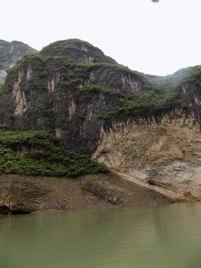
The great Yangtze River flows down from the Himalayas through some of the most stunning scenery in China, in particular the legendary stretch known as the Three Gorges where millions of years of river erosion have carved out a spectacle to rival — and in stretches exceed — our own Grand Canyon.
Downstream is the eponymous Three Gorges Dam — a technological wonder of the world but also a source of great controversy. While it has allowed the production of enormous amounts of electrical energy, it has also raised the river’s water level over a hundred feet, displacing 1.3 million Chinese and in the process flooding towns and archeological sites and causing much ecological change.
One thinks of the similar effects of the Egyptian High Dam at Aswan, the building of dams by the TVA — and the loss of villages and farmland behind the dam at New York’s Great Sacandaga Lake. Nonetheless — the stretches of the river from Chongoing (familiarly known as “Chun-king”) down to the dam itself have become prime areas for the visitor to China — and a few hours on a cruise ship through the region demonstrate why.
Even before reaching the magnificent vistas of the Three Gorges themselves, the scenery is evocative — one might accurately describe it as mystical. Though the landscape exhibits enormous pinnacles and buttes, as in Arizona’s Grand Canyon, the climate here is very humid and the walls of the gorge are thick with vegetation.
The Yangtze is brown as the Mississippi, partly due to the heavy sediment load it bares from locations as far away as the high Himalayas, and partly due to effluent from riverside villages and sediment from mines drowned as the water rose behind the great dam. The river cuts steeply through verdant hills and mountains dotted with small villages — some reachable only by boat — and temples and pagodas from China’s past, often situated on slopes that are so steep as to appear inaccessible.
A land out of legend
The beautiful Shibaozhai Taoist pagoda rises surrounded by lush gardens near the peak of a precipitous limestone promontory reachable only by a hike up a steep incline and a harrowing traverse of a swaying suspended bridge. The wooden structure was built over 400 years ago, 12 levels tall and constructed without a single nail.

Inside it are narrow, twisting passages and shadowy alcoves, within which reside over-life-sized statues of Taoist deities and heroes. Their presence is disorienting, but in a pleasing way — telling visitors that they have entered a world parallel to their own but governed by unfamiliar figures.
That the pagoda and so many other relics of China’s past survived the barbarity of Mao’s Cultural Revolution is often a tribute to the wisdom of numerous local officials and citizens; alerted to the destructive intentions of the Red Guards, the locals papered the walls of many pagodas, temples, and other ancient relics with posters of Chairman Mao. This made the structures sacrosanct and untouchable by the mindless mobs.

This is a land out of legend. The channel of the river becomes narrow, and the buttes and pinnacles become higher and more precipitous. Waterfalls burst from hidden caves and gush down steep, narrow passes, not unlike those in the Hawai’ian islands, showing as many shades of green as it is said that a true Irishman can distinguish.
Soon our cruise ship docks and we disembark at a confluence where a narrow tributary called the Shennv Stream joins the river, and, like the Yangtze, the Shennv flows brown with suspended sediment from the high terrain above it.
Here we shuffle into small, elegant boats, painted in the traditional colors of red and gold. The boats are motorized but surprisingly quiet as they glide upstream — as are we, its passengers — for we glide into a stunning landscape of steep green slopes, reaching upward to sheer faces of limestone rock.
Springs burst from the dense forests and here and there an ancient rock staircase ascends from the river shore and vanishes mysteriously into the dense growth high above. A cloudburst a few hours before has fed a number of waterfalls that resolve into fine spray before they reach the river shore.
The high peaks of the Shennv valley are draped in low-lying clouds and before us is the inspiration for thousands of Chinese scroll paintings, depicting mystical landscapes in which human constructions disappear into the drifting fog.

The evocation of the hidden valley of Shangri-la in James Hilton’s romance “Lost Horizon” is inevitable. Here in the valley of the Shennv is a world green beyond belief, appearing untouched by any human presence, far removed from the noise, the pollution, and the human turmoil of the world outside
Through centuries of Chinese history in which ruthless dictators and benevolent despots built their fortresses and walls and fomented revolutions and waged wars, the Shennv has flowed beneath towers of ancient rocks and dense forests of trees that seem never to have known an ax.
But soon it is time for our quietly moving tour boat to return us to our cruise ship on the Yangtze, time to return to a world of schedules and obligations and technology. And, in the days and weeks that follow, we are left to ponder: Did we, or anyone, really enter — if ever so briefly — that hidden, primeval valley?
And yet, in our thoughts remain those mysterious, mossy staircases, rising from the rocky banks of the Shennv and vanishing into the misty wilderness above.
— Photo by Mike Nardacci
The storybook entrance of Spider Cave, newly acquired by the Northeast Cave Conservancy, beckons research assistant Devin Delevan.
Barton Hill looms above Route 146 as it descends to the village of Gallupville and extends north as a series of impressive limestone cliffs along Route 443 to its intersection with Route 30. From there it stretches to the east with long, gentle slopes and is capped by flat stretches and some of the glacial hills above Routes 7 and I-88.
The name “hill” here is generic, for it is in fact a plateau, an isolated segment of the Appalachian Plateau, cut off millions of years ago from Terrace Mountain (also a plateau), Vroman’s Nose (a mesa), and the Cobleskill Plateau by the respective creeks known as the Fox, the Schoharie, and the Cobleskill.
In addition to the craggy cliffs, its landscape features include broad, fertile farmlands and thick forests — and it also contains numerous karst features: sinkholes, underground streams, and extensive cave systems, not all of which can be entered but which betray their existence through cold springs that burst from the base of the lofty cliffs. Caboose Cave, Schoharie Caverns, Single X cave, and Gage Caverns (historically and again today known as Ball’s Cave) are some of the caves known to geologists and sport cavers, and enormous occluded sinkholes such as the oddly named Joober Hole indicate there are many more.
Until recently, just two of these caves — Gage and Schoharie caverns — have been accessible to sport cavers with the proper credentials because they are owned and managed by the National Speleological Society, an international society devoted to the science and sport of cave exploration. But recently, through a generous donation, another organization known as the Northeast Cave Conservancy has acquired Spider Cave on the south side of Barton Hill, making it available for both student study groups and exploration.
The Northeast Cave Conservancy is a not-for-profit organization that has been managing and acquiring through purchase or donation a number of caves in this part of the country. The NCC has thus been able to keep open a number of caves that might otherwise have been declared off-limits by their owners for fear of liability or for other personal reasons.
For many years, Spider Cave was off-limits to cavers, but the cave with its beautiful entranceway, easily visible from a road, was described in old guide books as having a “storybook entrance but a short story!” To enter the cave, one must first climb a trail up a precarious slope that borders a stream gushing from the entrance.
The stream tumbles over rocks that are rich with Devonian Period fossils and brilliantly green with mosses and algae. The picturesque entrance is a shadowy opening in the Manlius Limestone and it leads to a narrow, twisting passageway that can be traversed on foot through the stream for some distance, though squeamish cavers may find themselves contorting their bodies to avoid disturbing the residents of the eponymously-named cave: dozens (sometimes scores) of large black spiders sequestered in nooks and crannies or openly displaying themselves on the cave walls.
But then the walls of the cave begin to pinch inward, the floor rises, and most visitors turn around as it becomes increasingly difficult to move without having one’s clothing caught and torn by the hard fossils and sharp erosional features on the passage walls. The extent of the cave remains unknown but cavers’ anecdotes tell of intrepid explorers crawling painfully on their sides through pools of icy water, their necessary wetsuits being shredded by the sharp projections from the walls, and turning back after 1,200 feet — or perhaps 1,500 feet — or possibly more, but leaving a small rock cairn to indicate their turnaround point.
Caves with small dimensions can suddenly and without warning open up into caverns of vast proportions — but Spider seems simply to plunge onward into the plateau, guarding well whatever secrets it holds.
The puzzle
And therein lies the puzzle that is Barton Hill. A topographical map featuring the underground passages shows that the known caves run parallel to each other — following what geologists call the “dip” of the rock layers; the “dip” is nothing more than the angle and direction at which rock layers (called “strata”) are tilted.
In this region, the dip of the strata of Barton Hill is gentle and to the southwest. For some of the caves, the insurgences — that is, the points at which water enters the caves from the surface, usually through sinkholes and fissures — is known. For others, the insurgence points have not been identified
This is not unusual, especially in a place like Barton Hill that in many places is covered with layers of glacial deposits, which may obscure features such as sinkholes. But finding the insurgence point for the water in Spider Cave would give an indication of its length, and might provide a way into the cave’s larger sections — if larger sections exist — through a sinkhole or an enlarged fissure.
And particularly odd are the physics and the chemistry of the water emerging from the springs — or “resurgence points” — along the base of the cliffs. During times of normal rainfall, some of the springs above Route 146 may be releasing water — and yet others, sometimes only a couple of hundred feet away — may be dry, though during spring snowmelt or following times of excessively heavy precipitation all of the streams may be gushing. Clearly, something odd is going on underground regarding the flow cycles of the subterranean streams.
Complex questions
The chemistry of these streams also raises complex questions. Cave waters are often saturated with calcium carbonate, and so a cave’s ceilings, walls, and floors may exhibit stalactites, flowstone, stalagmites, and curious dam-like structures in the streambeds themselves called “rimstone pools.”
These form as the water flowing through the cave or entering through cracks in the ceiling “de-gasses” — that is, it loses its carbon dioxide that makes the water acidic and causes the dissolved calcium carbonate to be deposited on ceiling, wall, or floor.
But Barton Hill has some springs known as “tufa” springs: These occur when for some reason the cave water retains its carbon dioxide and calcium carbonate as it flows underground, perhaps in a very small aquifer without any air space, preventing the saturated water from “de-gasing.”
In these situations, as the stream resurges from the cliff base into the open air, the sudden pressure release will cause the water to “de-gas” much as a carbonated beverage de-gases when its bottle cap is removed. Now the dissolved calcium carbonate will be deposited on whatever is in the path of the stream: rocks, twigs, or masses of moss or plant fragments, making the materials appear to be coated with light-colored paint or forming a spongy-appearing rock known as “tufa.”
Calcium carbonate can also form a natural cement and bind together enormous quantities of what geologists call “glacial till,” the mixture of rock fragments and soil left by the retreating glaciers. An extensive area of the hill slope between Gallupville and Shutter’s Corners has been cemented together into a kind of conglomerate by this process; here mineral-saturated water from ancient springs in the cliff far above the slope deposited so much of their dissolved calcium carbonate that they eventually sealed themselves up. This particular outcrop is heavily fractured and appears poised at some point to slump down the hillside onto Route 443.
The stretch of Route 146 approaching Gallupville has several other springs besides Spider Cave, but only one is easily recognizable as a tufa spring and at various times of the year when there is heavy precipitation or snowmelt, the underground stream feeding the spring produces great quantities of tufa that end up tumbling down the stream bed as cobbles or boulders.
Yet, oddly enough, the stream cascading down from Spider Cave also has a mass of algae-and-moss covered tufa in a small area its bed, but not in the stretch above or below it. Clearly, there is something unusual occurring in the chemistry of the stream flowing through Spider Cave that is seasonally altering the acidity of the stream — what chemists call “pH.”
Finding the stream’s insurgence point and examining the terrain under which the water flows on its way through Spider Cave might help to explain its curious behavior.
Numerous studies have been done of the geology and the known caves on Barton Hill; perhaps the best known among cavers and professional geologists is contained in Prof. John Mylroie’s doctoral thesis, “Speleogenesis and Karst Geomorphology of the Helderberg Plateau, Schoharie County, New York,” published in 1977.
But the occluded sinkholes, the shadowy fissures, the numerous bubbling springs, and the still-unexplored stretches of caves both known and unknown tell us that the beautiful forested plateau yet holds many secrets.
Location:

— Photo by Mike Nardacci
Sand Beach, Acadia National Park's most popular attraction, is a "pocket beach" sheltered by a rocky shoal and by the rocky peninsula known as "Great Head," featuring popular hiking trails.
My first experience with Acadia National Park on Mount Desert Island in Maine was in the summer of 1987 when I went as a graduate student to the College of the Atlantic in Bar Harbor for a course in the island’s geologic foundations. I was assigned a dorm room in a refitted mansion from Bar Harbor’s Victorian heydays, one of several on the college’s campus.
With the enigmatic name of “Seafox,” the building sat on a low cliff right above Frenchman Bay and had a view out over the cluster of fir-tree crowned, rocky islands known as the Porcupines to the far shore of the Schoodic Peninsula and the Gulf of Maine beyond it.
It is a stunning view, and it evoked in me a line from John Denver’s ballad “Rocky Mountain High”: “…Comin’ home to a place he’d never been before.”
Mount Desert Island — the locals insist on pronouncing the middle word “dessert,” as in baked Alaska — is roughly 12 by 17 miles and shaped like a huge lobster claw. Its interior is rugged: 30 or so named peaks with steep slopes and barren, wind-blasted summits that belie their fairly low elevations, making them seem far higher than they really are and posing a challenge to even experienced climbers.
The glacially-sculpted valleys between them are thick with deciduous trees — oaks, maples, and birches — as well as balsams, spruces, and other conifers. One mountain-bordered valley called Somes Sound is a deep, briny body of water with an uncanny resemblance to Lake George; it is Maine’s only fiord, a U-shaped glacially-cut valley filled with sea water.
The ocean water surrounding Mount Desert Island — MDI for short — is achingly cold, and even at the climax of a hot summer it is unusual for it to get above 55 degrees; tourists visiting an MDI beach for anything more than a very brief, bracingly cold dip are usually well-advised to head inland to one of the island’s numerous ponds and lakes which commonly reach 70 degrees by August.
Waves meet bedrock
But most visitors to the island’s ocean beaches are not there for swimming: They are there to take in the stunning scenery that results when the powerful waves come in off the Gulf of Maine and crash into the hard bedrock of the island. It is mostly granite, but in a few places it is made up of hard sedimentary rock and a metamorphic rock called schist.
All of these rock types are very ancient, the youngest being from the Devonian period — roughly 400 million years old, while the oldest — the schist — dates from the Cambrian and Ordovician times, roughly 550 million years in age. When the powerful Atlantic waves meet the bedrock of Mount Desert Island, the results are what the tourist brochures call “eye-popping.”
And fortunately, some of the most spectacular are easily viewed from Acadia’s Park Loop Road, which skirts a long section of the coast before heading into the fragrant forest of interior Mount Desert Island.
Every high school student is familiar with the diagram in the Earth Science Reference Tables showing the relationship between the velocity of water and its consequent ability to move rock particles. To describe it simply, the higher the yearly average velocity of a stream or a wave, the larger the particles it can move.
Very slow-moving water — a meter (roughly one yard) per second or less — can transport tiny particles such as silt, clay, and sand, and some diminutive pebbles; but as the water’s average velocity increases to 4 or 5 meters per second or higher, it develops the ability to transport increasingly huge boulders, and sometimes to hammer away at bedrock, leaving nothing but sheer cliffs rising from the sea.
“Sand Beach”
Given the island’s location off the coast of Maine, exposing much of it to the full power of the ocean, it is not surprising that sandy beaches are uncommon on MDI. In fact, there are just two, and one is artificial, with truckloads of sand required every few years to keep up with the ocean’s erosive power to take it away. But the other is natural, and it affords one of the most breathtaking views on the island.
Named perhaps a bit too literally “Sand Beach,” it sits on the side of the island that faces directly east making it a tempting target for the huge waves that roll in off the Atlantic all the year around. But Sand Beach is what geographers call a “pocket beach.”
It sits tucked back into a broad, shallow valley, protected partially on its east side by the craggy peninsula called “Great Head” and to its south by a large rocky shoal known as “Old Soaker.” Against both of these features, powerful waves break and lose much of their power.
Thus they are unable to blast away completely the sand that ends up on the beach, either washed down from higher areas on the island or transported along the coast by off-shore currents. Probably the singular most popular visitor draw on the island, it offers in summer a gorgeous place to sunbathe, picnic, and perhaps to test one’s ability to withstand the numbing but bracing waters without fear of the ocean’s ability to create crushing waves and rip currents.
Safe haven
The picturesque village of Bar Harbor is located on the edge of Frenchman’s Bay, named for the explorer Samuel De Champlain. The bay has been known since the days of sailing ships as a safe haven from the wild Atlantic waves.

Still, not far off the coast the surrounding waters are very deep, and in spite of the existence of a scattering of islands and an artificial breakwater, relatively strong waves frequently break against Bar Harbor’s shores, washing away small sediments such as silt and sand but leaving larger ones such as pebbles in place.
The village sits on the sedimentary sandstone and siltstone bedrock known as the “Bar Harbor formation.” When the rock is eroded by waves, it tends to break down in layers, which in turn weather into small, flat fragments, resulting in what is known as a “shingle beach.”
During times of accelerated wave velocity, such as in a storm, the fragments clatter against each other, becoming smooth from the grinding and producing a haunting sound. Those who remember Matthew Arnold’s beautiful poem “Dover Beach” from their school days may recall that it was just such sounds on an English beach that inspired his philosophical musings.
Given the fact that vast stretches of Mount Desert Island have harder bedrock than underlies Bar Harbor and are exposed to waves more powerful than those at the village, it follows that many of the island’s beaches are scenically rugged, especially along the east coast of MDI, both north and south of Sand Beach. In these locations, waves are on average powerful enough the year around to wash away all but the largest sediments.
Little Hunter’s Beach
A number of cobble beaches have formed, with some of the sediments produced directly from their underlying bedrock, and vast quantities were transported there by the great glaciers that covered the island 20,000 years ago. A particularly photogenic example is Little Hunter’s Beach, named for a stream that spills down and into the ocean from the high forest looming above the beach.
The rounded cobbles that bury the bedrock several meters deep here come from numerous points to the beach’s north, many from inland Maine. They are of many kinds and brilliant colors: granite, basalt, schist, and other rock types, rounded and polished by centuries of wave erosion.

There is a direct relationship between the force of the waves and the steepness of a beach surface, so traversing Little Hunter’s is a challenge, akin to walking on an enormous, slanted pile of billiard balls. Like Sand Beach, Little’s Hunter’s is also a pocket beach, tucked back a couple of hundred feet into the landscape — but Little Hunter’s faces open ocean, and only the distant Cranberry Islands somewhat lessen the waves’ power to remove sediments.
Hence the beach is made largely of cobbles, with smaller pebbles visible only at the waterline at low tide, when wave energy is often much lower. The beach is bordered by woods filled with balsam firs, spruces, and bayberry, and the cold breeze that blows over it carries their fragrance for great distances.
Powerful waves
A few miles north of Little Hunter’s is a section of coast open to the full fury of the Atlantic and here are found what geologists call “high energy” beaches. In these areas, the waves have sufficient energy to leave behind nothing but boulders or have blasted away all sediments and left massive cliffs rising starkly from the raging ocean waters.
A boulder-strewn beach that is easily visible from the Park Loop Road is called “Monument Cove,” a recess cut back a couple of hundred feet into the bedrock, which consists of the beautiful deep-pink Cadillac Mountain Granite, forming 60-foot cliffs that tower above a jumble of boulders, some a meter or more in diameter.

It can take waves moving 1,000 centimeters per second — over 30 feet — to move rocks of that size; but the rounded and smoothed appearance of the rocks testifies to waterflow of that power, providing a spectacle of furious waves and foam and the roar of the sea during the occasional off-shore hurricane or one of the many winter storms that pound the Maine coast.
And yet — areas of Maine’s coast can be subjected to even greater wave velocities, and the stretch near Anemone Sea Cave is a sobering example. Anemone Cave harbors a population of sea anemones, in addition to sea stars, sponges, and other delicate life, and to protect it the National Park Service has long stopped publicizing its location.
However, that location makes it hazardous to humans as well. The water immediately off the shore here plunges to great depths, permitting enormous waves to blast away at the coast with very little frictional drag from the bottom. The result is that, in this stretch of Mount Desert Island, there is no beach in the conventionally understood sense of the word at all.
Instead, there are high cliffs rising directly out of the sea, featuring precipitous drops, and a combination of the relentless forces of frost action in winter and the rhythmic, endless surges of giant waves have blasted out a sea cave. Such caves are relatively rare on the east coast of the United States, but common farther north and on the west coasts of both the United States and Canada where waters tend to be deeper and waves more powerful the year around.
Great diversity
Mount Desert Island has long been known to naturalists and oceanographers as a tremendous outdoor laboratory where creatures ranging in size from tiny ones such as plankton to far larger ones such as whales and a spectacular variety of plants may be studied; to geologists, it offers beautiful examples of all of the major rock types and the forces that from ancient times have created and weathered and eroded them.
But the island has also for many centuries drawn a great diversity of visitors as well: Native American Indians fishing the rich waters, sailing ships seeking a safe harbor during storms, and city-dwellers looking to escape summer heat. But it has also drawn lovers of the island’s natural beauty and artists seeking to capture the astounding landscapes created when the angry ocean meets rock.
Location:

— Photo by Michael Warner
The spectacular tower karst landscape of Guilin Province in China is a geologic wonder that has inspired many generations of Chinese artists.
When I started composing this article in my head, this thought came to me: “tower karst” and “Onesquethaw” — two rather obscure terms (to most people) — in one headline. Might be an attention-grabber!
The Onesquethaw is the stream that originates in Helderberg Lake and flows southeast — sometimes through impressive canyons and over surging rapids — on its way to the Hudson River. It passes photogenically through a number of diverse natural preserves, some of which I have written on in the past in this column.
“Karst” is the geologic term for an area of carbonate bedrock — most commonly limestone, but occurring in marble, dolostone, and gypsum as well — with resulting characteristic landscape features. Each of these rock types dissolves in slightly acidic water, and, given the amount of moisture in Earth’s atmosphere and the carbon dioxide emitted by decaying vegetation on the floors of forests and fields, there is no lack of mild carbonic acid on our planet.
When the acid meets the limestone, sinkholes, caves, underground streams, and bubbling springs are frequently the result. But, even in the same general areas of the Earth’s surface, outcrops of the same rock type may weather and erode at different rates and leave behind odd and even fantastic remnants of the bedrock — a phenomenon known as differential weathering and erosion. Think of the great buttes and pinnacles of Monument Valley beloved by Western filmmaker John Ford.

Famous Asian landscape
The landscape of Guilin Province in China — commonly pronounced “Guy-lin” — is famous the world over, figuring in thousands of classic Chinese paintings and ubiquitous on the walls and menus of Chinese restaurants: giant limestone towers wreathed in morning mist, often featuring diminutive rice farmers or fishermen dwarfed by the magnificence of the rocky scene.
These towers are the last remnants of ancient limestone layers hundreds of feet thick. They are laced with enormous cave systems and in some cases have been used by the inhabitants of Guilin as dwelling places and temples for thousands of years.
They have a mystical, otherworldly look to them and their attraction for artist and visitor as well is obvious. And, though the towers of Guilin are perhaps the best known to travelers, there are many other such sites in Southeast Asia and elsewhere in the world.
Helderberg discovery
As often as I have hiked the hills and forests of the Helderbergs, I am still astounded to find fascinating geologic phenomena in places that — for one reason or another — I have managed to miss in my travels.
Though I have followed the valley of the Onesquethaw Creek through many of its twists, turns, and drops, there is one area off Rarick Road south of Route 32 that had escaped my notice until a long-time friend and fellow caver Thom Engel asked me if I knew that there was a display of tower karst in a natural preserve owned by the Mohawk Hudson Land Conservancy. It is called the Onesquethaw Creek Preserve; it is a bit tricky to find in the thick forest that borders Rarick Road and there is no clearly defined parking area.
But Thom was able to get his feisty little Honda Fit off the road on what might once have been the beginning of an old logging trail, and, after a short hike, we found the fairly well-defined path that leads into the preserve. Like many of the forested areas of the Helderbergs, the trees grow thickly, forming a green canopy that keeps the ground relatively free of large, dense shrubs, which obscure the view.

The surface undulates and the relatively thin ground sediment is a mixture of soil and glacially deposited pebbles, cobbles, and boulders known as glacial drift. Tree roots tend to spread out horizontally due to the thinness of the sediment, and walking is a bit precarious.
We had gone only a few hundred feet when we found ourselves confronted by the first of at least a dozen pinnacles of the Coeymans limestone, this one featuring three rounded peaks. It was highly weathered and covered with mosses, ferns, and other shade-loving plants.
Diminutive compared to the lofty towers of Guilin — 20 feet in height compared to the Chinese towers that soar hundreds of feet — it was definitely an example of tower karst, and scattered around it were others of equal or lesser height.
Exploring the mystery
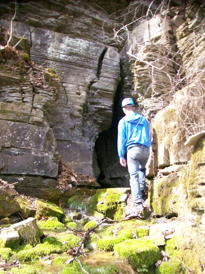
As it happened, the sky was overcast that day, making the woods rather gloomy, and so I returned on a sunny day a week later with my research assistant, Devin Delevan, to take more photographs and to see if I could come up with some explanation of why these features had formed here. One tower with a double peak was a particularly striking example, and Devin climbed part way to the top to show scale.
The pinnacles stand close to the edge of the Onesquethaw Creek, which in this stretch usually appears as a dry bed buried in rounded boulders and soil, showing flow only in times of exceptionally heavy spring melt or a storm event such as a tropical storm or hurricane.
But its appearance is misleading, for, in karst lands, streams often are flowing underground. In many stretches of the Helderbergs, one can drive for considerable distances without seeing a major stream; however, under the surface, extensive cave systems such as the eponymous Onesquethaw Cave near Clarksville as well as Albany County’s Knox Cave and Skull Cave, and Howe Caverns, Secret Caverns, and Ball’s Cave in Schoharie County feature streams that eventually resurge from valley walls or artesian springs to find their ways to the Hudson or Mohawk rivers.
We hiked some distance upstream of the karst towers to the higher area near the edge of the preserve — beyond is private property and farmed land. Here the ground flattens out for a long distance into a level stretch, which geologists call a bench, likely planed off by the glaciers. We soon heard the sound of flowing water, incongruous given the exceptional dryness of the downstream bed.
Shortly, we came to a portion of the stream bed that was radically different from its downstream character It is a wide, flat exposure of bedrock limestone, which is obscured by the glacial deposits in lower parts of the preserve: dimpled with numerous potholes and deeply fractured, with some rifts several feet deep.

Slightly farther upstream, hundreds of gallons of water were pouring over the exposure, forming pools full of clear or froth-laden water, many of which were inhabited by seeming thousands of inch-long tadpoles. A startled great blue heron interrupted his lunch and took wing when he spotted us but undoubtedly returned after we had left, unwilling to abandon such a fruitful feeding ground.
We then discovered that the ponded areas covered in froth also exhibited small whirlpools, and the rotating water could be heard gurgling as it was sucked downward. Here the Onesquethaw goes underground much of the time, just as it does in the stretch near Clarksville that parallels Route 443 where Route 85 joins it, only to reappear farther downstream.
And this explained the dryness of the stream in the lower portion of its bed: The water is moving through a subterranean conduit — in common terms, a cave. The fact that so much water was simply vanishing from the surface hints of the size of that conduit — yet we searched in vain to find an entrance that would admit a human being.
Joints across the universe
But that open expanse of deeply fractured rock offered a tantalizing clue to the existence of the tower karst features. An examination of the fractures reveals that they occur in straight lines and frequently intersect at something close to ninety-degree angles. These fractures are referred to as “joints” and they occur everywhere in bedrock.
The Mars Rovers Spirit, Opportunity, and Curiosity have shown joints to be common in Martian bedrock as well. There are a number of ways in that they may form. When erosion removes upper layers of rock — or massive glaciers melt at the end of an ice age — the lower layers, free of all that immense weight, are allowed to expand, and their uneven rate of expansion causes the rock to crack.
Earth, the violent clashing of the tectonic plates sends shockwaves for many miles beyond their collision boundaries, fracturing the rock often to great depths. Mars is not believed to have active tectonic plates, but a third possible method of formation is the uneven expansion and contraction of the bedrock due to heating and cooling at different times of day and the year, a process which certainly occurs on Mars and other planets.
Once the joints form, weathering agents such as water and ice can enter them and begin the process of widening and deepening them. Particularly in a carbonate rock such as limestone, the solution process can go down as far as the water table. Then, as over the centuries the water table drops, the joints in the rock can continue to widen and deepen.
Due to differential weathering and erosion, some areas will break down faster than others. In the photograph of Devin on the flat outcrop, note that some stretches are more highly fractured than others, and consequently will eventually disappear faster than the more massive, unfractured stretches. In centuries to come, these more massive areas could emerge as examples of tower karst.
The limestone strata (layers) in this part of Albany County are around 100 feet thick, so there is a limit to the heights tower karst features can reach — unlike in Geilin and other areas of Southeast Asia where the limestone can be a thousand or more feet in thickness. But it should be noted that anywhere they appear, the towers have emerged from rock that formed in seas that covered the landscape scores or hundreds of millions of years ago.
And it should not be a surprise that, beneath the mosses, lichens, ferns, and other hardy plants that can grow in the thin soils atop the karst towers of the Onesquethaw Creek Preserve, one might find fossils of trilobites, brachiopods, gastropods, and other shelled creatures that dwelt in the warm and shallow sea that covered this part of New York State a couple of hundred million years before the first dinosaurs ever walked the Earth.
Location:

The Enterprise — Michael Nardacci
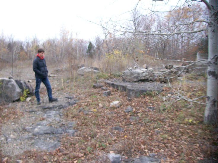
A gigantic upended fragment of the Helderberg escarpment dwarfs research assistant Devin Delevan. The fragment, partially buried in sediment, was probably brought down by some of the last glacial ice to leave Albany County.
Geologists, I have often told my students, have a name for virtually everything. For most people, an expression such as “debris that collects at the base of a cliff” would be sufficient to describe debris that collects at the base of a cliff!
But geologists find such an expression rather cumbersome — many of them write astonishingly fine prose — and to avoid that wordy phrase they have coined the term “talus.” It is a generic term, for when cliffs are as high and massive and diverse in their layered rock types as our Helderberg escarpment is — some layers being soft and thin-bedded and easily weathered, others being extremely hard and massive — they will break down and produce fragments ranging in size from clay particles to gigantic, jumbled slabs.
Then under the force of gravity and the many agents of erosion—ice, water, and wind—they will begin their journeys to lower elevations on the slopes: journeys that may take moments or days or centuries.
The Helderberg escarpment rises from close to the level of the Hudson River near Ravena and then moves northward on a gradual tilt that lifts it a couple of hundred or so feet per mile, reaching its greatest elevation at High Point above Altamont, where it turns west and gradually diminishes.
Its most prominent cliff is made of two layers of hard limestone — the Lower Manlius and above it the Coeymans — but those layers sit on alternating beds of relatively soft sandstone and shale known as the Indian Ladder beds and are capped by the Kalkberg and the New Scotland limestones, and other beds of shale, sandstone, and limestone. All of these layers have been subjected to millennia of attack by the forces of nature, and the result is that the escarpment sits on a talus slope hundreds of feet high.
It is a hauntingly beautiful environment, radically different from the orchards and cornfields that border it. The haunt of crows, ravens, pilgrim thrushes, and (in spring) migrating white-throated sparrows, vast forests of deciduous trees and hemlocks on the slopes have had to grow to great heights in order to reach sunlight and have produced a world of perpetual green shade and trickling water.
Since the slopes also face north, whatever sunlight gets through the forest canopy never strikes the ground at a steep angle and the environment tends to be very humid. Humidity is conducive to weathering and so the bedrock layers are buried under dirt and gravel and larger rock fragments, providing an atmosphere like that of a terrarium, and with similar results.

Every surface is covered with plant life, from the top of small, flat rocks to the massive boulders that moved down the slopes long ago, probably under the influence of the last glacial ice that covered this area. These are plants that thrive in a wet environment with limited light: violets, trilliums, jack-in-the-pulpits, wild ginger, trout lily, Dutchman’s breeches, and a vast variety of ferns, among others.
They appear soon after the last snow is gone and bloom for a few days and then vanish for another year. But one in particular is sought after not for its exotic flower but for its odor and taste: the wild ramp, also known as spring onion, wild garlic, and by other names.
The leaves of wild ramps somewhat resemble those of the lily-of-the-valley, but to the alert eye they signal the presence of a wild onion with a sharp taste that is both sweet and spicy; its odor and flavor can make something very special of an otherwise commonplace dish.
Once their shiny leaves appear, it is a matter of just a couple of weeks before the bulbs swell to half an inch or more in diameter. Then, as they are dug from the ground, their zesty onion odor permeates the air.

Washed and with their roots cut away, the ramps may be used as flavoring in dozens of dishes; they may be boiled or roasted, or they may simply be eaten raw, giving the tang of spring to salads or plates of raw vegetables. After a few more short weeks, the leaves wither — among the first of all forest plants to turn yellow as the season progresses — and vanish until the next year’s spring melt and first warm days awaken them again.
An Internet search for “wild ramps” yields upward of 60,000 sites; one quickly learns that wild ramp festivals are held in many Appalachian sites in the spring. And many of the websites deal with the folklore associated with the plants.
Medieval and early American populations believed the plant to have medicinal qualities — but, of course, onions have long been known to be good for digestion and for the heart. Probably the more outrageous claims of the ramp’s health-giving qualities are myths, but one can easily understand why the stories have arisen.
For following a cold, snowy, barren winter such as the one we just experienced, suddenly the newly greening forest features a modest-looking plant, which — when drawn from the ground — yields a fragrance as fresh and as invigorating as spring itself.
And what better way to experience the return of the warmer weather than to take a stroll through the forests of the Helderberg talus slopes to enjoy the greenery, perhaps catching a glimpse of the 42 shades of green that it is said every Irishman can distinguish; to listen to the music of the newly-arrived birds and the trickling of the last snow melt; and amid the exhilarating smells of the woods to be fortunate enough to catch the tang of the wild ramp.
Location:

— Photo by Mike Nardacci
A polished slab of Becraft limestone shows its numerous Devonian period fossils.
— Photo by Mike Nardacci
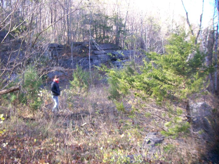
The Knox Fossil Rock Quarry is now inactive. The subject is standing on an outcrop of Becraft limestone right at its contact with the overlying Oriskany sandstone.
— Photo by Mike Nardacci
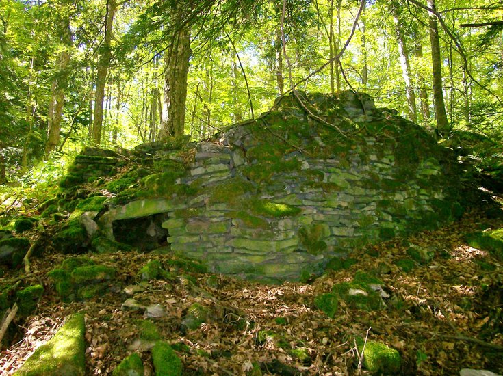
A dilapidated lime kiln in Joralemon Park near Ravena is one of dozens scattered throughout the Helderberg region
— Photo by Mike Nardacci
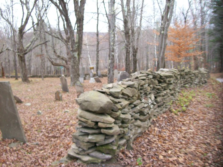
The stone wall in the historic cemetery on Peasley Road near Rensselaerville is constructed of Helderberg bluestone.
— Photo by Mike Nardacci
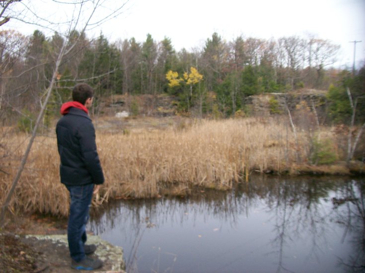
The abandoned Helderberg bluestone quarry in the formerly bustling village of Reidsville is quiet now.
— Photo by Mike Nardacci
The Rock Hill Road limestone quarry, the products of which were once used in the manufacture of Portland cement, has long since been abandoned.
— Photo by Mike Nardacci
An exterior wall of the Western Diner in Guilderland shows numerous brachiopod fossils found in the Oriskany sandstone.
With the Helderberg landscape buried under yet another huge snowstorm in this seemingly endless winter, many of the unique geological features of our area are hidden beneath the drifts. Fortunately, the subject of this column is fine for the “armchair” geologist — all that is needed being a good imagination!
I put together a number of photos I took with the help of my reliable assistant, Devin Delevan, in the fall and during that warm period we had in mid-December — and voila! — a meditation on the ancient rocks of the Helderberg Plateau and the long-abandoned quarries from which they once were drawn.
And I would like to start with a site which is one of the most accessible — at least when the region is not groaning under the weight of all this snow.
****
The hamlet of Reidsville is today but a shadow of what it once was. “Blink and you will miss it” is an apt cliché. It lies on the Cass Hill Road, a lovely stretch of back road that climbs steeply up onto the hills above Clarksville and passes through miles of forest filled with rambling old stone walls before intersecting with Route 85 just west of Reidsville.
The hamlet consists of a few houses, a barn or two, and a mossy old cemetery whose occupants surely outnumber the current living population. But back in the first third of the 20th Century, Reidsville was a bustling town of hundreds of inhabitants and featured two churches, a number of stores — and the bustling Reidsville bluestone quarry.
The quarry today is unimpressive and easy to miss. A broad depression lying on the north side of Cass Hill Road as one approaches the hamlet’s crossroads, it is filled with stagnant water and cattails, a haven for peepers in spring and bullfrogs in summer.
A couple of abandoned tires have been dumped into it. Other vegetation has taken hold in the dry areas and only the angular outcrops and low vertical cliffs hint that the depression is not natural.
In the wooded areas surrounding it, piles of the shattered bluestone once quarried there lie covered with weeds and the debris of eight decades of seasonal changes. According to a 1934 article in The Enterprise, the quarry ceased operations in 1933 due to the arrival on the scene of a building material that, although used extensively by the ancient Romans, had recently become easily-available and relatively inexpensive: concrete.
And, in fact, Portland concrete doomed hundreds of other stone quarries throughout the Northeast and elsewhere in the United States as cut stone — once essential for many building projects — became prohibitively expensive and began to be used more commonly as a luxurious decorative facing stone. (An old geologists’ joke says that the difference between “rock” and “stone” is that stone is rock you have to pay for!)
And, indeed, looking around the older parts of cities, one notices far more cut stone than would be found in most modern-day building projects. The massive amounts of white Vermont marble facing the buildings of the Empire State Plaza contributed to the enormous cost of the project.
A television documentary recently revealed that, for a while in the early 1960s, New York State wanted the Albany Catholic diocese to encase the venerable Cathedral of the Immaculate Conception — built from red sandstone — in the same white marble as the plaza so it would “blend in.” Obviously, the cost of such extravagance was a major factor that contributed to the shelving of that idea — and, one would hope, someone’s sense of historicity and aesthetics did as well.
A 1935 geologic map of the Berne Quadrangle shows that the Reidsville quarry was one of numerous bluestone quarries once active in the Helderbergs, and a drive around some of the back roads of the area will reveal them to be in a state similar to the one at Reidsville. But for many years they provided work for hundreds of laborers, and their products are visible in areas such as downtown Albany and Troy where sidewalks were frequently constructed from the stone.
Helderberg “bluestone”
In this part of New York State, “bluestone” is a common term for a hard sandstone of late Devonian age — roughly 360 million years old. It is not really blue — in its freshly-cut stage, it is a rich, attractive dark shade of gray sometimes tinged with green and it tends to weather to black or brown depending on its iron content.
Helderberg bluestone originated in what is known as the Catskill Delta that emerged during the Acadian Orogeny (mountain-forming episode) as the landmass that would one day be called Europe collided with proto-North America and threw up a series of lofty mountains to our northeast. The sediments that washed down from those mountains filled in the shallow tropical sea in which our local limestone layers formed and produced a series of interlocking deltas, creating environments in which forests of some of the earliest large land plants would emerge. The Gilboa Petrified Forest is a well-known example.
In the Helderberg area, the rock does not typically show many fossils, though in other locations it may feature trilobites and brachiopods and other typical Devonian marine fauna, most of which are extinct today. In Oneonta and the upper Catskills, the fern tree fossils and fragments of some of the other early land plants become common, evidence that the strata in which they occur formed in non-marine environments.
Today, much of the bluestone that is still quarried commercially is sold from outlets such as the eponymous Helderberg Bluestone on Route 443, which takes the stone from but a single active quarry. Since it easily separates or is cut into flat slabs, it is used widely in retaining walls, just as it has been used for hundreds of years in the Helderbergs for walls and foundations.
The historic cemetery on Peasley Road near Rensselearville features a beautifully constructed example.
Oriskany sandstone
Another somewhat less commonly used Helderberg building stone is known as the Oriskany sandstone, named for what geologists call its “type location” at Oriskany Falls in Oneida County.
The Oriskany is what is known as a “calcareous” sandstone, meaning that it has a high content of calcium carbonate in addition to quartz sand and it is believed to represent both near-shore and on-shore ancient beach deposits. Such beaches are found in many tropical areas of the world today and Acadia National Park’s famed “Sand Beach” is a temperate-zone example of the type.
It is a relatively thin layer — averaging no more than 2 to 4 feet in most areas of the Helderbergs though it thickens greatly to the south of the area. The Oriskany is widely prized as a decorative facing stone because it contains enormous quantities of large brachiopod fossils, which stand out impressively as the rock weathers.
A currently inactive quarry near the village of Knox on Route 156 — formerly known as the “Knox Fossil Rock Quarry” — was used for years as a source of the Oriskany.
A wonderful display of its fossils may be seen in the fireplace of the old Hofbrau Restaurant on Warner’s Lake (now the Maple Inn) and exterior walls of the Western Diner on Route 20 in Guilderland where the large — sometimes fist-sized — shells of the ancient creatures appear in the thousands, some in fragments but many intact, just as they would have been found on a Devonian-Period beach.
When the Oriskany is exposed to years of weathering, the carbonate materials tend to dissolve away, often leaving the sea shells — with a high silicate content — easily visible.
Limestone layers
The Helderberg escarpment that rises to the west of Albany is composed of three major limestone layers. The thin-bedded Manlius limestone and the massive Coeymans limestone above it make up the more prominent cliffs, visible from many miles away on a clear day as a stark gray band, tilting gently to the south. The two are believed to have formed from the carbonate-rich ooze at the bottom of a relatively warm, shallow sea during the Devonian Period.
Many Helderberg and Schoharie area caves are formed in these limestone units, which dissolve readily in naturally occurring acids. In the stretch of countryside between Altamont and New Salem, the two layers have a combined thickness approaching one hundred feet, maintaining a similar thickness as they stretch south along the Vly Creek Reservoir
Approximately 140 vertical feet higher is a second, slightly less prominent line of cliffs composed of the Onondaga limestone, also a major former of caves. The Onondaga is light gray and in its lower reaches contains layers and nodules of chert, a hard silicate rock commonly known as flint.
Above Thacher Park, the upper Onondaga forms an extensive flat landscape known as a “bench” on which the northern stretch of the Beaverdam Road was constructed, and along which numerous small sinkholes and some short caves have formed.
None of these three limestone units has been widely sold as a commercial building stone, but the relative purity of all three layers made them valuable in the making of Portland cement in years past. The limestone was harvested from now-abandoned quarries such as the one found on Rock Hill Road near the Vly Creek Reservoir and smashed into jagged boulders, which were then burned in wood-fired lime kilns to drive off the volatiles.
Ruins of many of these kilns lie scattered throughout the Helderbergs, often covered with mosses and lichens and calling to mind the so-called “Beehive” buildings constructed by the ancient Celts and scattered throughout western parts of the British Isles and France. Locally, Callanan Industries and the extensive quarry in the village of Howes Cave continue to quarry limestone for this purpose.
All three of the units also found use in the construction of foundations for houses and sometimes entire buildings, as testified to by the beautiful stone dwellings in the Onesquethaw Valley south of Clarksville and the handsome Onesquethaw Reformed Church, all of which were built from the Onondaga.
And, of course, the hundreds of miles of old stone fences that lace the woods of the Helderberg and Cobleskill plateaus were built of these and other types of rock found locally and constitute some of the best places to collect Devonian period fossils.
The last and perhaps rarest of the Helderberg area stone used decoratively is the beautiful Becraft limestone. The Becraft is not widely exposed on the plateau, and in most places it has a thickness of only 12 or 13 feet, though, according to the well-known New York State geologist Winifred Golding, in its type locality — Becraft Mountain near Hudson — it reaches a thickness of 45 feet and was also once quarried in the making of Portland cement.
It is described as an example of “coquina,” made up almost entirely of variously-sized shell fragments cemented together — in this case by calcite. Coquina tends to form in what are called “high energy” environments: areas in which powerful waves remove very small fragments but leave behind enormous quantities of whole or partial medium-sized shells that then get naturally cemented together.
The Becraft is thus a very hard rock and, when broken, it tends to have a great many jagged edges — the protruding shell fragments. The only quarry I am aware of in the Helderberg area where the Becraft was cut commercially is again the old Knox Fossil Rock Quarry.
Due to its hardness, the stone will take a high polish and was used for decorative counters and tabletops. An example is on an antique dresser that I refinished a number of years ago and for which I purchased a polished slab from Helderberg Bluestone to replace its damaged top.
Strata with evocative names
There are a number of strata of other rock-types found in the Helderbergs which have evocative names but have found less commercial use: the New Scotland limestone, the Brayman shale, the Rondout waterlime, the Esopus grit.
These strata, along with those discussed above, form a gigantic layer cake, some of which is visible in natural outcrops, much of which is buried under layers of glacial sediment and luxuriant forest growth. To the geologist, the strata indicate episodes of ancient seas rising and falling, of continents colliding, of ecosystems changing, of strange creatures evolving and flourishing or going extinct.
And, for the inhabitants of the Helderberg area, they have long provided stone for purely practical purposes, of course, but they have also provided materials for decoration that are not only beautiful but tell of diverse worlds, gone forever into the labyrinths of the ages.
Location:
Caves are mysterious places even for those of us who have spent decades in exploring and trying to understand the agents of nature that formed them, and it should be noted that for a large percentage of the world’s population, caves are “terra incognita.” Someone once called the subterranean world “The Eighth Continent,” and it is probably far less familiar to most people than anything they might have learned about Antarctica.
Think of the number of stories, novels, films, and TV shows that are set wholly or partially in caves, often wildly — even hilariously — inaccurately portrayed to those who are knowledgeable about them, but undoubtedly appealing to some aspect of the human subconscious that has a fear of dark, unknown chambers that exist in what is melodramatically — but not inaccurately — described as the “bowels of the earth.”
It is therefore not surprising that visitors to caves often ask questions that, due to the questioners’ innocence, might seem pretty silly to those among us whose avocation — and sometimes vocation — involves the sport and science of caving.
When I first started teaching a high school earth science course to freshmen and a geology and astronomy survey course for seniors, I still harbored a remnant of a notion instilled in me in one of those education courses required of aspiring secondary-school teachers, sometimes taught by a professor who seemingly has never been within a mile of a classroom filled with adolescents (said Mike cynically): that notion being that the only dumb question is the one that is not asked.
But that got kicked out of me after a couple of years when I was finishing up a two-week unit on stars and stellar evolution with my seniors.
We had talked about the birth of the universe — old beyond imagining — and we had analyzed the Hertzsprung-Russell diagram; we had compared the sun with red dwarf stars and massive blue giants, discussed the formation of red giants, neutron stars, and black holes; and we had looked at dozens of slides of open clusters of blazing stars arrayed about a nucleus like swarming bees; spectacular nebulae spangled with gases and dust of every color of the spectrum; spiral galaxies, barred spirals, elliptical galaxies, irregular galaxies, all of them fantastically huge and beautiful beyond belief — and all of them sufficient to make one wonder in the silence of one’s bed at night if those folks who believe in intelligent design might just be on to something.
I was wrapping up our discussion in preparation for a test on the unit the next day when I remarked that, in spite of all the discoveries made by wondrous instruments such as the Hubble Telescope, there were still many things that we do not know about stars.
At that moment, a rather sleepy-looking student who shall remain nameless and who — as I recall — had not shown much more than tentative signs of life during his weeks in my classroom, raised his hand. When I called on him, he asked, “When the astronauts go up in the space shuttle, can they go outside?”
Confused by the seeming irrelevance of the question I replied, “Yes, of course. But what does that have to do with the test tomorrow?”
The look on his face suggested he had hit on something that had evaded all those amateur astronomers like Steven Hawking and Neil DeGrasse Tyson and he said smugly, “Well, next time they go up there, why don’t they just go outside and get a couple of stars, and bring them back down to Earth?”
Needless to say, the reaction of some of the more knowledgeable students in the class was — shall we say — less than charitable toward the student’s question and they showed it, while I tried not to crack a smile at this young man’s total cluelessness and gently explained what he should have known weeks before: Stars are a bit too large and hot to fit into the cargo bay of a space shuttle.
How much of a cave is underground?
Anyone who has ever guided a group of tourists through a commercial cave or taken a group of wet-behind-the-ears novices on their first “wild” cave trip has, of course, heard many, many preposterous inquiries — and it requires the patience of Job not to roll the eyes, sigh like a spouting whale, and say, “That is a seriously silly question.”
Years ago, when I had taken another group of students on a week-long trip to Mammoth Cave, we were on what was called the Historic Tour, and our guide — all decked out in his Park Service uniform and Smokey-the-Bear hat — told the crowd of about a hundred that the only dumb question was the one they didn’t ask.
After a couple of fairly intelligent questions that had to do, as I recall, with the age of the cave and the great size of the passageways, the ranger pointed to an anonymous hand waving above the crowd and said, “Sir?” At which point came the question, “Is all of this cave underground?”
I have made it a point whenever I am taking a tour through a commercial cave to ask the guide — when I can catch him or her out of earshot of the rest of the tourists — what is the silliest question they have ever been asked. As it happens, that question about whether all of the cave is underground is a fairly common one.
If the guide can resist the temptation for sarcasm, he or she might say simply, “All that we know of it is.” A guide once told me he had replied, “All of it except for the gift shop and cafeteria” — and drew not a smile from the questioner who seemed to accept those areas as, indeed, being parts of the cave.
Compendium of questions
And, so what follows is a compendium of questions that either I have been asked or questions I have acquired from commercial cave guides.
— 1. How long did it take the Indians to carve this cave out?
This is also a surprisingly common question asked of cave guides. People who have no understanding of erosion and chemical weathering are bound to be mystified and awed by the great size of some cave passages — Mammoth Cave’s Main Passage has room for a modern jetliner to fly through it.
But caves form because surface water has picked up carbon dioxide from the atmosphere or from decaying plants and becomes mild carbonic acid. When this acid comes in contact with calcium carbonate — the main constituent of limestone and marble — it dissolves it to a solution of calcium bicarbonate, which then washes away.
Given the right conditions and enough time, the process can form out huge cave passages. And as for that silly question: If Native American Indians had carved the cave — what on Earth did they do with all that rock they hauled out?
— 2. How thick are the walls of the cave?
The sedimentary rock from which most caves are dissolved forms in layers, which often cover thousands of square miles. In the Helderberg area, most of our large caves (including commercialized Howe Caverns and Secret Caverns) have formed in one of three types of limestone: the Manlius, the Coeymans, or the Onondaga.
The Manlius limestone is found as far west as Syracuse and as far south as Port Jervis; the Coeymans stretches from New York to Virginia; and the Onondaga stretches as far west as Detroit. Each of these areas consists of thousands of square miles, so trying to figure how thick the walls are would be a monumental task, but a good answer would be, “Really, really thick
— 3. How much of the cave hasn’t been discovered yet?
One would think that the response to this question would be something flippant, such as, “We won’t know until we discover it.” But, in fact, it is sometimes possible to come up with an intelligent answer.
If the known passages in a cave have formed in a geographic region throughout which the same geologic conditions exist, there is a good possibility that many more passages have formed under sections that have not been surveyed. By measuring the length of passages in a set area, one might by inference conclude that a lot more of the cave has not yet been discovered and perhaps even extrapolate a rough estimate of how much.
At Mammoth Cave in Kentucky, for example, the same geologic conditions exist for hundreds of square miles, beneath some of which are over 400 miles of explored cave. But, by extrapolation, geologists have concluded that there could be in excess of one thousand miles of the cave when — or if — Mammoth is ever fully explored.
— 4. Is any of the light down here natural?
Since caves are roofed by solid rock that can be many hundreds of feet thick, with rock walls that can be hundreds of miles thick, and with bedrock floors that may literally stretch to the Mantle of the Earth, it is highly unlikely that any natural light could enter beyond what cavers romantically but accurately call the “Twilight Zone.”
This is the region near a natural entrance to a cave into which dim sunlight may reach, and that may have unusual ecologies, featuring both plants and animals that exist in a world of feeble light and perhaps wildly changing seasonal temperatures.
Sport cavers carry their own lights (a minimum of three is the requirement) and commercial caves have complex and often expensive electrical systems for lighting.
— 5. How many undiscovered entrances to the cave haven’t been found yet?
When asked such a question, cave guides must be tempted to say, “We’ll know when they have been discovered.”
But again, what seems to be a no-brainer actually can have a rational, scientifically based answer. Caves form in regions of limestone or marble bedrock known as “karst.” Karst areas usually are characterized by mainly subterranean drainage of runoff into extensive cave passages, numerous springs, streams that tend to go underground shortly after they get started, and a surface pock-marked with the depressions known as “sinkholes,” which permit surface waters and sometimes human explorers to enter the caves below them.
But sinkholes can become occluded: wholly or partially blocked up by sediments and other natural debris that may effectively cut off everything but water from entering the cave systems.
Scientists known as hydrogeologists who study the effect of local geological conditions on water flow — above as well as below ground — have developed a technique known as “dye tracing” to permit following the flow of water to places humans cannot go. This process involves placing harmless dyes in water that is sinking into the ground and then watching the suspected resurgence points to see if the dye-laced waters emerge, indicating there has been a connection.
My young research assistant Devin Delevan is pictured standing at the brink of a vertical sinkhole near the village of Clarksville, an area known to have extensive cave systems. Though in the photograph the sinkhole is dry, in times of heavy precipitation dye could be added to water, pouring into it and a connection might be determined.
Karst areas often have hundreds of such sinkholes, many of which could be hooked into a cave system through this method, even if a human could not physically enter the cave. Numerous previously “unknown” entrances could thus be identified.
— 6. What happens if there is a fire while we are in there?
This question was actually asked of me some years ago when I was guiding a group of students from a downstate New York college through Clarksville Cave.
One young man took a look at the cave’s tight, intimidating entrance and a vision must have passed through his head of a dozen students madly fleeing from flames and battling each other to get out of the cave. His question elicited a burst of laughter from several of his fellow students who were clearly aware that there was nothing within the cave that would be capable of a conflagration.
I assured him of that fact and his face turned red and I expect his question went the rounds through the dorm that night, much to his embarrassment.
— 7. How much does it cost to air-condition (or heat) this cave?
Since limestone and marble and other kinds of dense rock are good insulators, beyond its Twilight Zone a cave will remain pretty much the same temperature all the year around. Caves generally will assume the average ambient temperature of the area in which it is located, making caves seem cool in summertime and warm in winter — everything being relative to temperatures outside the cave at a given time.
In the Helderberg/Schoharie area, yearly average temperatures are about 50 to 52 degrees Fahrenheit, and that tends to be the temperature of our caves. No artificial cooling or heating is required.
Two truly preposterous queries
There are undoubtedly many more Seriously Silly questions that cave scientists and guides have to deal with, but then there are the ones that are truly preposterous or totally incoherent, and I will end with two of these.
Not long ago, I was touring a commercial cave with a group of students and popped my question to the guide, a young woman college student. She did not hesitate for even a moment. Last year, she told me, she and several other guides had been asked a question that was the talk of their crew for several weeks: People on tours were asking, in all seriousness, “Is this the cave that was moved from New Jersey?”
Understand: The visitors’ portion of this cave is over half a mile in length and in places 60-feet high. How and from where the idea had circulated that it had been moved from another state no one seemed to know, but, not wanting to risk losing her job over a condescending reply, the guide had answered simply, “No, it’s been right here in Schoharie for thousands of years.” The guide reported that no one in her group had even cracked a smile.
At the same cave the year before, I had posed my question to a young man who was majoring in geology at a local college. He told me that some weeks before, while his group was standing on the banks of the cave’s gurgling underground stream, a visitor had asked “Is the water in this stream real? Or is it natural?”
Aware that the man’s question was absolutely serious — but unable to decipher its meaning and unwilling to prolong the issue by asking the man to explain what he meant — the guide replied, “Actually, we have both in the cave.”
The man nodded and seemed satisfied.
And that stunner and the one my student asked me about packing up stars in the space shuttle and bringing them back to Earth have permanently put an end in my mind to the notion that the only dumb question is the one you don’t ask. Professors of education, take note.