
The Enterprise — Mike Nardacci
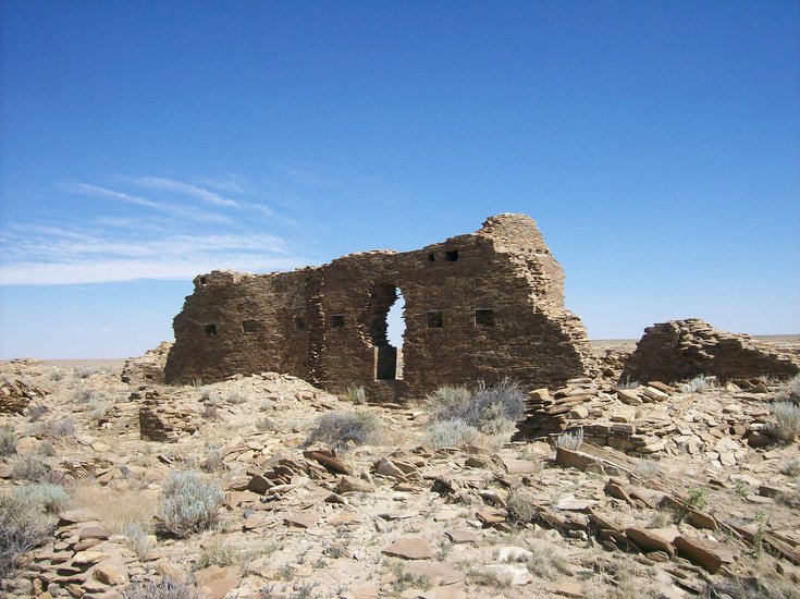
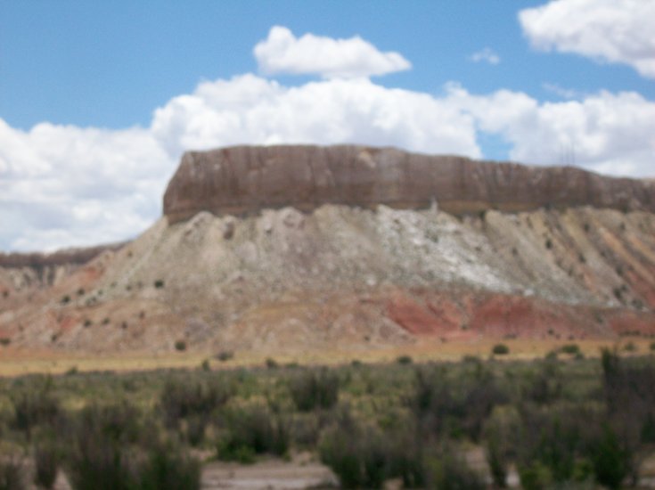
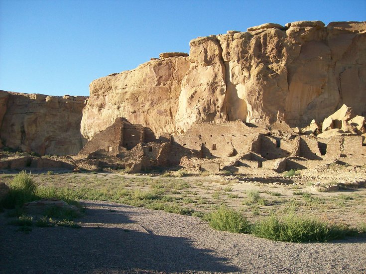
From a distance, the ruins of Penasco Blanco resemble natural rock outcrops protruding from the top of the mesa.
The Enterprise — Mike Nardacci
A “doorway to nowhere” in Penasco Blanco is part of ruins that have stood unoccupied for nearly a thousand years.

The Enterprise — Mike Nardacci
From a distance, the ruins of Penasco Blanco resemble natural rock outcrops protruding from the top of the mesa.
The Enterprise — Mike Nardacci
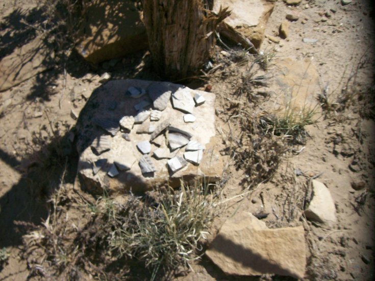
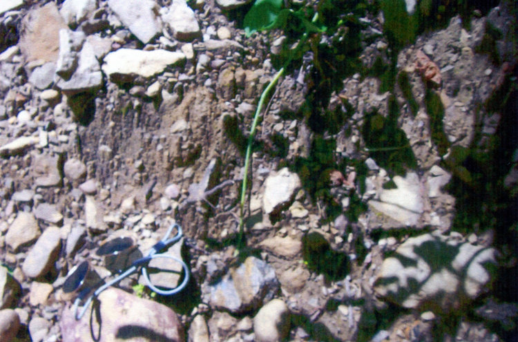
Fragments of Anasazi pottery: In some areas, they lie in thick layers, evidence of centuries-long occupation of the ruins.
The Enterprise — Mike Nardacci
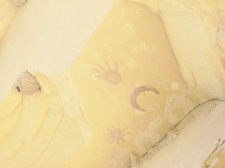
This ancient pictograph is believed to show the supernova of 1054 A.D. with a crescent moon and what may be the artist’s handprint above it.
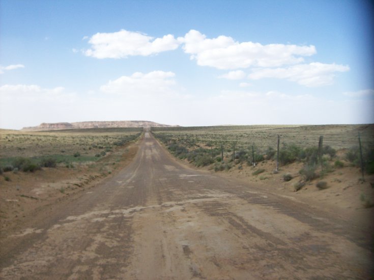
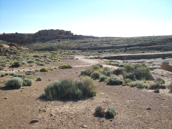
Bordered by sagebrush and other sparse desert vegetation, the washboard-surfaced road to Chaco Canyon traverses a barren, waterless landscape.

The Enterprise — Mike Nardacci
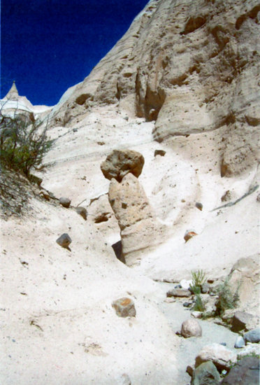
Huge boulders, like this one, exhibiting honeycomb weathering, are common in arid landscapes.
The Enterprise — Mike Nardacci
A barren talus slope is topped by sheer cliffs along Highway 550 in New Mexico.
By Mike Nardacci
The term “geopoetry” seems to have been coined by Scottish poet Kenneth White to describe geologic writing that shows “the relationship of the Earth and the opening of a world.” The idea is that the few known facts of a situation are combined with intelligent speculation to evoke its mystery and wonder — but not necessarily to provide definitive answers.
I have always believed that anyone who aspires to an understanding of geology needs to have a vivid imagination: To stand, for example, on Route 156 between Voorheesville and Altamont and look at the Helderberg escarpment rising above you and envision it 20,000 years ago buried under the mile-plus-thick continental glacier. Or to project your mind farther back into the Devonian Period 400 million years ago when this part of New York lay under a warm shallow sea dotted with low coralline islands that, through the fantastic processes of plate tectonics, would rise up into the looming, fossil-rich plateau we see there today.
Over the past decade, I have made several trips to Chaco Canyon in New Mexico, a spectacular preserve about a hundred miles northwest of Albuquerque off of Route 550, but often described by visitors as being “a hundred miles west of Nowhere.”
The highway passes through some of the bleakest terrain in the United States, though some of it is starkly beautiful, as arid landscapes tend to be, bordered by miles of desert plants: sagebrush, cactuses, and cholla, towered over by angular mesas and buttes formed of dusty, pastel-colored rock.
Chaco is then accessed by a truly horrendous 13-mile-long washboard-surface dirt road, which surely is intended to discourage all but the most determined of visitors. Although designated as a National Historical Park, Chaco has no facilities beyond a campground that offers rather primitive camping (though it does feature flush toilets), and a visitor center, which is, as they say, “under renovation.”
It is air-conditioned and has a small shop selling a variety of books that theorize about Chaco’s human history, but had — as of this past June — no exhibits at all, which is a shame considering that a few years back it had a museum featuring fascinating displays and presenting information about Chaco’s spectacular Anasazi ruins and the ancient people’s stunning architecture and pottery.
Mystery and miracle of water
In June of this year, I was again hiking in Chaco with a friend, Mike Whalen, who is a filmmaker living in Boulder, Colorado. The temperatures were somewhat lower than we had expected: mid-80s in the late afternoons but relatively cool and dry early in the days, and so we chose one particularly clear morning for a hike to a pueblo ruin known as “Penasco Blanco,” the most remote in the immediate vicinity of Chaco and one that we had never managed to visit on previous trips.
It lies atop a mesa at the end of a relatively flat three-and-a-half mile trail that leads out over the dusty floor of Chaco Canyon through vast stretches of sagebrush and cactuses, some of which were late blooming in exuberant shades of red and yellow and orange in the wake of the spring rains. The path at first follows the base of the canyon’s North Mesa and has some shady stretches, but the last mile-and-a-half or so are out in the open.
Frequent examples of honeycomb weathering may be found in the boulders at the base of the cliffs. This phenomenon — fairly common in extremely arid environments — seems to occur when salts within the rock migrate toward the surface and form crystals that shatter it. The shady recesses undoubtedly provide respite from the blistering sun for desert birds and reptiles. Though the temperature was still in the 70s, the high sun shining through a cloudless sky soon became oppressive and we found ourselves gulping down our water faster than we had planned.
And it is true that, among the great mysteries of Chaco Canyon, one of the most perplexing revolves around the subject of water.
The people of many ancient cultures thought of water as something spiritual — even sacred. Temples were built over springs, which must have been regarded as connection points between the world of the gods and that of humans.
It is not hard to see why and it is on the subject of water that this essay ventures into geopoetry. Consider the appearance of the landscape on the road from Albuquerque to Chaco: Much of it consists of plateaus and mesas composed largely of shale and siltstone but capped by hard sandstone forming steep escarpments above the crumbly talus slopes.
The situation is rather comparable to the stratigraphy of the Helderberg plateau, where the shale- and soft-sandstone talus slopes towering above Voorheesville and Altamont are capped by the hard Manlius and Coeymans limestone layers that form the vertical cliffs of Thacher Park. But the Helderberg area is a very wet climate and the slopes — and indeed, every fissure and hollow in the cliffs — are green with massive amounts of vegetation. As the song says, “The hills are alive….”
The New Mexican talus slopes show signs of the occasional turbulent movement of water — but then, so does the surface of dry and dusty Mars. Yet, aside from pinyon pines and junipers on the valley floor that somehow manage to find enough moisture to thrive, the slopes in the New Mexican scene are nearly devoid of life, whether plant or animal, and the changes brought by abundant water verge on the miraculous.
Doors to nowhere
The trail to Penasco Blanco crosses a small dry wash just before it makes the final steep ascent of the mesa, and in a sheltered alcove above the trail is an ancient pictograph — one of the most remarkable ever discovered. It seems to record the appearance of a crescent moon and next to it a supernova that was observed in other parts of the world as well in 1054 A.D.
Clearly, the ancient inhabitants of Chaco Canyon took a keen interest in the stars and one of them made the effort to record the stellar explosion; the handprint may well be that of the artist.
On this mid-June day, the wash was indeed very dry and probably had not had any flow since the sparse spring rains following the melting of whatever light snow cover had fallen on the canyon. Beyond the wash a series of exposed switchbacks led to the top of the mesa, and, as we climbed up to the crest, we were presented with a view of the Penasco Blanco ruin a thousand or so feet away.
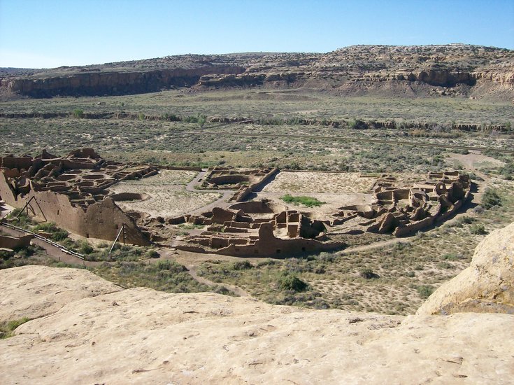
The ruin is immense; ovular and greater in area than a football field, it was subdivided into hundreds of rooms and passages and courtyards — home, it is believed, to perhaps many hundreds of puebloan people.
A dozen or more of the sunken, circular pits known as kivas — which served as places of worship and socialization — are scattered about it. The ruin is mostly unexcavated, so the tumbled-down walls and doors to nowhere stand picturesquely on the windy mesa as they have for centuries, and in places the ground is littered with fragments of the Anasazi people’s beautifully decorated pottery.
The low hills around it reveal the partially exposed walls of other, smaller “satellite” pueblos that were built as Penasco Blanco grew and expanded.
Questions persist
Surveying the ruins, built so deftly from millions of rock fragments, we were confounded by a number of questions. The first had arisen a year ago when Mike and I hiked to another ruin called Pueblo Alto, remotely situated on Chaco’s North Mesa: What was the source of all the rock fragments from which the ancient pueblos were constructed?
The landscape around the ruins is covered with shattered rock, though it is likely that the vast majority of these have weathered from the walls of the ruins themselves. Undoubtedly many more lie buried in the dry soil, but excavating them in that sometimes scorching heat would have been agonizing.
The bases of the various mesas are littered with innumerable fragments of the needed sizes — but transporting them up the cliffs to the building site in the thousands of tons needed would be an appalling task even with modern technology. From all evidence, the ancients had nothing to rely on but arm- and leg-muscle power — and this fact is one of the major aspects of the Chaco Canyon mysteries.
But, as we stood there draining our canteens under the glaring New Mexican noon sun, another even more provocative question arose in our minds: How did the ancient people supply the builders with water?
We tried to envision great teams of workers engaged in construction activities that in some ways must have posed many of the same challenges that faced the builders of the Egyptian pyramids. But the pyramid builders had the Nile River at their feet — an endless supply of water for drinking, cooking, washing, and probably bathing when the heat became unbearable.
Southwestern museums often display hollowed-out gourds and huge ceramic pots that are believed to have been used by the ancient people for water storage. But to store water, one must first obtain it, and, here in the vast dry stretches of Chaco Canyon, the only source of water other than rare precipitation is the Chaco Wash — a narrow streambed incised into the compacted soil of the canyon floor that, except for brief periods in spring and the occasional August gulley-washer, is never more than a sluggish, muddy trickle, and it is over a mile from Penasco Blanco.
Clearly, it could never have provided enough water for this pueblo’s builders let alone the construction teams raising the other pueblos of Chaco Canyon.
And that fact raises another major question: How were the workers and the inhabitants of the pueblos fed?
The builders of the great Egyptian monuments had the well-watered and incredibly fertile fields of the Nile Valley to provide their food. But, although for millennia the inhabitants of the Southwest have been expert at what is called “dry farming” to raise the “three sisters” crops of corn, beans, and squash, one can only wonder how the ancients managed to produce enough food for the teams of workers building Penasco Blanco as well its inhabitants — and one must keep in mind that Chaco Canyon holds over a dozen other large pueblos and innumerable smaller ones.
But even “dry farming” requires essential amounts of water, so once again the question arises: What was its source? And how was it transported to the top of the mesa in sufficient quantities to allow Penasco Blanco to expand and flourish?
A survey of the literature both popular and more technical on the subject of Chaco Canyon shows researchers with wildly differing interpretations of the reasons for the construction of the pueblos of Chaco Canyon, of estimates of its population, and of the enormous problems that revolve around the source and quantities of food and water.
But one fact is critical: Water is life.
Hence, scientists today are excited by the discovery that, in the far reaches of our solar system, the moon Europa, orbiting Jupiter, and the smaller satellite Enceladus, orbiting Saturn, show evidence of being the repositories of gigantic quantities of water in both liquid and solid states: beckoning targets for future exploration.
And yet here in one of the most hostile environments in the United States, a thousand years ago a great culture grew and flourished, reaching startling technical and artistic heights that evoke admiration and even awe today.
What made it possible was water. But where that water came from and how the ancient people obtained and transported it are questions that science is nowhere near answering. “Geopoetry” indeed!
Location:
The Enterprise — Michael Nardacci
Damoiselles: A pair of sunglasses shows the size of the tiny structures near the entrance to a Clarksville area cave. Pebbles in the clay matrix have protected the sediments beneath them, forming little columns.
The Enterprise — Michael Nardacci
Hoodoos eroding out of a glacial drift on the Normanskill at “Ghost Fire Bend.” These structures change radically from year to year because of heavy precipitation.

The Enterprise — Michael Nardacci
A sweeping view over Tent Rocks State Park stretches to Sandia Mountain near Albuquerque.

The Enterprise — Michael Nardacci
A sweeping view over Tent Rocks State Park stretches to Sandia Mountain near Albuquerque.

The Enterprise — Michael Nardacci
A few stubs are all that remain of some very old hoodoos. Others show the classic shape while newly forming hoodoos emerge slowly from the surrounding slopes.
The Enterprise — Michael Nardacci
A massive boulder compressed the sediment below it, protecting it from erosion — a textbook example of hoodoo formation.
A point I have always tried to make with my students or participants in one of my field trips is that geologists have a name for absolutely every natural process involving the rocky sphere that is Planet Earth. And one of the wonderful things that has happened in recent decades is that scientists have sent robot probes to examine the surfaces of other planets, as well as asteroids and comets, and have found not only that many of the same processes occur on worlds as alien as the Moon, Venus, and Mars, but have discovered exciting evidence of other geologic phenomena unknown on Earth and waiting to be explained.
Over the past few days, the Internet has been sizzling with reactions to a rock photographed by the Curiosity Rover that has a passing resemblance to a thighbone. Given the fact that not one of the robots sent there has yet found persuasive evidence that anything as large as a microbe ever lived on Mars, the curiously shaped rock is unlikely to be anything but that: a curiously shaped rock.
But the various chat rooms that dwell on such things are buzzing with charges that NASA (the National Aeronautics and Space Administration) is once again concealing evidence of macrobiotic life on Mars and those who disagree are denounced in vitriolic (and often hilariously ungrammatical) language.
Yet the fact is that the natural processes which change the shape of Earth’s surface are sometimes capable of producing very curious results: hence, the chess-piece shapes of the rocky towers of Bryce Canyon, the elegantly sculptured mesas and buttes of Monument Valley, and the granite profile of New Hampshire’s Old Man of the Mountains that collapsed ignominiously some years ago into a heap of rubble due to frost-wedging.
A few weeks back, on emerging from a trip with some students through one of the caves near the village of Clarksville, I noticed some odd, miniscule features on a pile of muddy debris at the cave’s entrance. The debris was glacial drift, deposited on the Clarksville area by one of the streams pouring off the melting Ice Age glaciers thousands of years ago: hundreds of penny-sized and smaller pebbles in a matrix of packed clay.
But many of the pebbles stood atop a small, thin column of that clay, forming tiny structures geologists call by the French term “damoiselles”— which loosely translates as “little maidens.” Evidently, to the French-speaking geologists who coined the name, the pebbles resembled broad bonnets perched atop the slender structures below.
This happens when rain water or melting snow cascades down an exposure of soft sediment, washing away anything that is not protected by the tiny pebbles; their weight has slightly compressed and hardened the materials on which they sit.
In many places in the world, these structures appear on a much larger scale. Chimney Bluffs State Park on Lake Ontario features enormous examples, which are often given the name “hoodoos” when they form such massive structures. A somewhat smaller display of hoodoos appears on the mysteriously named “Ghost Fire Bend” of the Normanskill, though these are currently not accessible by car with the closing of Grant Hill Road due to road work.
In June of this year, while on a hiking trip to New Mexico, I had the opportunity to visit Tent Rocks State Park on the reservation of the Cochiti Pueblo, southwest of Santa Fe. The preserve was originally given the Keresan language name Kasha-Katuwe, which is usually translated as “rocks that resemble teepees.”
Here, between 6 million and 7 million years ago, the land was buried under the debris from an incredibly violent volcanic eruption that formed the Jemez Caldera, a giant bowl-shaped depression to the north. Layers of the soft, spongy-looking rock known as pumice, compacted rock fragments called tuff, and volcanic ash buried the region in layers hundreds of feet thick.
The weight of all of that air-borne sediment compacted the strata into a crumbly matrix rock that weathers easily due to the wildly varying seasonal temperatures and is poorly resistant to erosion by the occasional rainfall or melting snow. But mixed in with the smaller rock fragments are boulders, some the size of an automobile, and these had the effect of compressing and compacting the sediments that lay beneath them. Thus the sediments were protected from the raging, highly erosive waters that flow during those occasional periods in arid climates when sudden torrential rains fall.
The results are the hoodoos of Kasha-Katuwe, and they are marvels to behold.
Those found near the parking area for the preserve’s trailheads gave Tent Rocks its name. There are a dozen or more of them, ranging in height from a couple of yards to 20 or 30 feet, but these represent the last stage in the erosion cycle of the hoodoos. They have lost their protective boulder caps and, in respect to geologic time, they are not long for this world.
Though this part of the Southwest is currently experiencing a severe decade-long drought, every drop of rain that does fall is washing them down to ground level, the eventual fate of all hoodoos.
To get a better idea of nature’s inventive sculpting talents, one must hike up one of the two major trails that head into the park. They are easy for the experienced hiker, though the lack of shade and the unforgiving summer sun make it mandatory to carry a couple of quarts of water. In addition, signs warn of poisonous snakes lurking in the underbrush — sufficient cause for those inclined to bushwhack to stay on trail.
A textbook example of the formation of the hoodoos lies on the edge of the eroding mesa around which the trail meanders. Rising some 20 feet from the middle of a dry wash, the structure is crowned by a large boulder of pumice.
Farther along the trail, the hoodoos become larger and more varied in shape and one particularly steep slope offers a view of their entire life cycle: some eroded down to mere stubs, some proudly displaying their protective caps, and others just beginning to emerge from the eroding cliffs.
They derive their weird shapes from the varying hardness of the rock strata from that they form. A slot canyon cut into the rock by raging waters offers a shady respite from the heat and climaxes in a hair-raisingly steep and exposed series of switchbacks leading to a jaw-dropping view out over the canyon to Sandia Mountain above Albuquerque.
The American Southwest — particularly in New Mexico and Arizona — features some spectacular geology due to its diverse rock types; its wildly varying elevations; and its climate, which tends to be arid but is subject to sudden intense flooding.
Terms such as “weathering,” “erosion,” “resistance,” “strata,” “frost wedging,” and other prosaic expressions may seem lifeless on the page of the textbook. But, in an environment such as Tent Rocks State Park, these dry words describe nature’s endlessly varied talent to create wonders in the rock from which Earth is made.
Location:

— Photo from Mike Nardacci
A field of glacial erratic boulders lies on a mountain west of the Great Sacandaga Lake.

— Photo from Mike Nardacci
Hadley Rock: Adirondack resident Steven Rider stands in the weathered-out fissure of an immense glacial erratic boulder
Acadia National Park on Maine’s “Down East Coast” is a place of mystical wonders: sheer granite cliffs rising from the sea, washed in the salt spray of enormous waves crashing against them; barren mountain peaks that seem much loftier than they really are, climbing upward from sea level and splashed with the colors of flowers normally found hundreds of miles farther north; spectacular stone bridges in the most unlikely places in the Acadian forests, gifted by John D. Rockefeller and looking like leftover sets from The Lord of the Rings films; and miles of fir and hemlock coastal forests, the dark green boughs hanging with the lichen called Old Man’s Beard, wreathed in fog and dripping in a silence broken only by the haunting cries of gulls and the clanging of buoys.
But Acadia is also an enormous outdoor natural history classroom, and educational institutions such as the College of the Atlantic in Bar Harbor frequently use its features for courses in geology, marine biology, botany, and environmental chemistry, among others.
The mountains of Acadia and other even higher summits in interior Maine must have been among the last places in the northeastern United States to have had glacial ice when the vast Wisconsinan glacier — the most recent continental glacier — retreated as Earth warmed over the last 15,000 years. U-shaped valleys, the odd asymmetrical mountains called “roches moutonnees” (which translates as something like “sleeping sheep”), bedrock showing the striations (scratches) caused by the advance of the glacier, and immense deposits of glacier-borne rock material all testify to the recent — in geologic time — Ice Age.
Glaciers are immensely powerful agents of erosion, and much of the upper part of the continental United States is covered in the debris they left behind.
The poet Robert Frost wrote frequently of the hardship of being a New England farmer — not the least of whose problems was the immense quantity of rock left behind in the landscape presenting an appalling challenge to the horse-drawn plough. His poem “Mending Wall” deals with the boulders — “some like loaves and some…nearly balls” that are ubiquitous in fields and which farmers for generations have used for stone walls and house foundations and churches.
The beaches of the Acadian Coast are famous for the almost infinite variety of types and colors of rocks found on them, many of which may have been transported for hundreds of miles from their point of origin: For it is a rule of glacial geology that an advancing glacier acts as a bulldozer, scraping away loose sediment and vegetation right down to the bedrock and then proceeding to abrade it, too, away; but a melting or evaporating glacier acts as a dump truck, leaving behind all sizes of rock particles from tiny clay and silt to huge cobbles and boulders in one heterogeneous mess called glacial drift.
The larger particles — the cobbles and boulders — are known by the quaint name glacial erratics. The high summits and slopes of Acadia are dotted with thousands of erratics, and on many of the peaks such as Cadillac Mountain, the highest mountain on the East Coast of the country, they sit in rugged isolation, often looking like the remnants of the mysterious rocky circles found in Ireland and England.
One of them is a famous landmark for visitors to Acadia: It is called Bubble Rock and it perches picturesquely on the steep slope of the summit of a small mountain known as South Bubble. It is an enormous chunk of the Lucerne Granite, a beautiful black-and-white speckled stone with large crystals that forms the bedrock some 40 miles north of Mount Desert Island
The sight of it challenges credibility: The slope appears to exceed the physicist’s “angle of repose” and it looks as if the slightest touch would send it careening noisily into the valley below it, smashing rocks and trees as it went.
Many visitors to Acadia National Park have appeared in the apparently obligatory photograph in which they attempt to dislodge it. Legend has it that, on a Halloween night some years ago, the entire football team of a local high school hiked up and attempted to push it off South Bubble. But there it stands.
A charming children’s book (now, alas, out of print) attributed the precarious position of the rock to Acadian trolls. But it must be remembered that on what is now the coast of Maine, the continental ice sheet was greater than a mile in thickness and thus had immense power to transport rocky materials: Retreating, it left this erratic and many others behind, sometimes in the most unlikely of locations.
Our own Helderberg hills and the Adirondacks also feature vast numbers of erratic cobbles and boulders, but, given the thickness of the forests that grow on them, erratics are often hard to spot, except when they are exceptionally large.
A relatively low mountain to the west of the Great Sacandaga Lake has a ridge running from its summit that features dozens of fairly large boulders of gneiss and anorthosite, transported from the High Peaks of the Adirondacks. Just below the mountain’s summit is a gigantic erratic, split down one side by frost wedging and the action of tree roots.
Far larger than Bubble Rock, it sits on a much gentler slope, and, located as it is in some fairly remote wilderness, it has likely had few visitors. Doubtless, hundreds more like it are scattered throughout the Adirondack fastness.
But we in the Albany area do not have to look far to find glacial erratics. Anyone who lives outside of the city of Albany — especially in the Altamont and Voorheesville area on the west side of the Hudson and in the Wynantskill and East Greenbush area on the east side — has found the same problem as the New England farmer in attempting to dig on one’s property: the enormous quantities of rocks in the soil.
They may have many different points of origin, of course, but one that is very common is a purplish rock often found as a smooth cobble or boulder, deposited directly by the ice or perhaps rounded and polished in a vigorous stream pouring off the melting glacier. These are samples of what is called the Potsdam sandstone and they originate far to our north near the border with Canada.
The fact that erratics’ points of origin can be determined with precision is useful to glacial geologists, who sometimes refer to deposits of such rocks as boulder trains. Appearing in more or less straight lines that strike roughly north-to-south, they allow the directional motion of the glacial ice to be determined very accurately.
When I am conducting geologic field trips, I usually toss out this question to participants: Just how long ago was the Ice Age?
Unless respondents are exceptionally knowledgeable, answers are usually accompanied by a shrug of the shoulders: “A million years ago?”
That is not a bad answer as a million years ago the ice was, indeed, in control of much of this part of the world.
But people are often unaware that even 10,000 years ago there was glacial ice on some of the highest peaks in the Northeast, and that we are living in what geologists call a glacial interlude.
But aren’t we in a time of global warming? Yes, there is evidence of that assertion. But all evidence is that the warmest Earth has been in the last 20,000 years occurred 7,000 years ago in a time geologists call the “hypsithermal,” and the glacial ice is poised for its return in a few thousand years.
In a few weeks, we will be entering the first stages of fall, and the average day-to-day temperatures will begin to drop. From time to time, we may see exceptionally warm days — we can all remember days in October and even November when the thermometer incongruously hit 80. But no one is foolish enough on such days to think that summer is coming back.
We are living in a geologic period of continental glaciers and the little purple stones in your backyard not only tell us that the last glacial advance was not so long ago; they may be harbingers of cold, cold days to come!
Location:
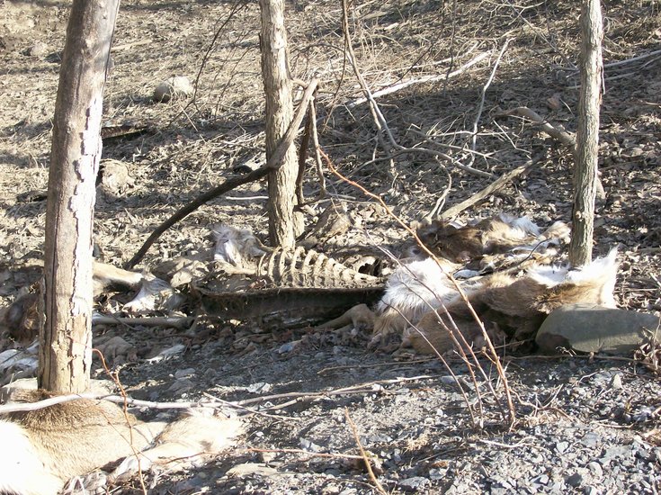
— Photo by Mike Nardacci
Deer carcasses rot in a sinkhole with waters that have been dye-traced to a spring over a mile away.
To anyone with an interest in the geology of the Helderberg Plateau, one of the pleasures of late March and early April is to take a drive around its back roads to see what the waters of the spring melt-off are doing.
When the snowpack of the plateau is subjected to the first temperatures in the 40s and 50s — especially when combined with a soaking spring rain — the cliffs and valleys gush with waters; their musical sounds signal that, though temperatures may yet perversely drop to unseasonably cold levels, the arrival of spring is irreversible.
And especially in regions with karst topography — where limestone bedrock has dissolved away to produce sinkholes and caves and springs — gullies that are normally dry may be flowing with temporary streams that vanish suddenly into gaping sinkholes, or spring unexpectedly from the ground, producing gurgling freshets that will be dry by early summer.
One chilly day about two weeks back, when the ground still had large patches of crusty snow and temperatures hovered near freezing, I took a drive along a gravel road not far from the hamlet of Knox to a monster sinkhole that lies much less than a stone’s throw from that road. It is large enough to show on topographic maps, and a geologic map of the rock layers (“stratigraphy”) of the area shows that, in its steep-walled, 50-foot depth, it punches through the surface Becraft limestone bedrock into the underlying New Scotland limestone.
Its picturesque rocky walls often drip with runoff and in warm months are green with mosses and ferns and wildflowers. At any time of year, it may take a stream and the waters have been dye-traced to a spring well over a mile away, indicating that somewhere beneath its muddy, rubble-strewn bottom there is a cave of considerable size.
Since I was a college student, I have been watching this sink, hoping that some fine day, following the spring floods, enough of the debris will have been washed through to admit explorers to the cave’s uncharted reaches: every cave explorer’s dream!
What I saw through the driver’s window even before I got out of my car unnerved me: I could see a couple of discarded tires littering one wall of the sink and, when I stepped out and could see the bottom, I spied several more.
But then I saw something far worse.
Directly in front of me, less than 20 feet down into the sink, were a number of rotted deer carcasses, perhaps half a dozen in all. The lowest ones were nothing but skeletons but those closest to the road still had hide.
Fifty feet or so to the right was another, and there appeared to be two more farther around below the rim of the sink, all of them perched on its steep walls, meaning that, when rain fell, it would pass through the carcasses and sink through the debris at the bottom, eventually finding its way to the cave system’s resurgence point.
I could just imagine what kind of crud and disease the carcasses might carry and all of it would be in the waters flowing from the unsuspecting owner’s spring.
The alluring sinkhole had become a dumping ground.
A week later, I returned with a camera and a friend, long-time caver Thom Engel, a retired Department of Environmental Conservation employee. This day was substantially warmer than the week before — now temperatures were in the low 60s, meaning that anything that had been frozen on my previous visit was likely to have thawed.
And no sooner had we stepped out of the car when we were hit with a slow breeze that carried the pungent, frightening stink of carrion. Besides the decayed corpses of the several deer and the rejected tires, there was other less-identifiable trash visible in the bottom of the sinkhole.
I quickly shot a couple of pictures and then we got back into the car and sped away from the vile-smelling vapors carried on the breeze. So much for the poet’s “gentle springtime zephyrs.”
It has long been illegal to dump waste into surface streams; what landowners today would pour used oil or dump the carcasses of dead domestic animals into a stream passing through their property? And, in any case, their downstream neighbors would be quick to see where their stream is picking up its filth.
Yet generations of people living on karst topography have seen sinkholes as tempting places in which to dispose of waste. A sinkhole, after all, may be very deep: a fire in the chicken coop kills a hundred hens, the work horse or ox goes to its reward, the much-worked-on pickup truck finally rolls over and dies — and the dead creatures or vehicles are dumped into a handy sinkhole, covered with a couple of tons of “clean fill” — and voila! The dead stuff is gone forever.
Not!
Sinkholes are not the “black holes” of modern astronomy and science-fiction, and a trip into them is not one-way. Soil — especially when it lies thickly over bedrock — can be a natural filter, and small amounts of pollutants can be trapped in subsoil as water infiltrates down to the water table.
But in landscapes with limestone bedrock exposed, surface streams frequently flow into sinkholes and then directly into karst aquifers — or “underground streams” to put it simply — and contaminants can enter the water table in a matter of moments.
There is no filtration of pollutants and extensive cave systems can carry them for miles, even under hills and ridges. Pity the landowner who discovers that the formerly pristine water source that springs from a mossy fracture in a cliff is suddenly redolent with the odor of anti-freeze or the stink of animal carcasses; and try to understand the bewilderment of a farmer perhaps miles away who cannot understand how the burned-out washing machine and the corpse of the cow that were buried in the convenient sinkhole that lies in a hedge row on his farm is polluting a spring that might be in the next township. After all — his ancestors have done that for generations, as other trash-laden sinkholes on the property bear witness.
But to understand is not to excuse.
I have deliberately been vague as to the whereabouts of the sinkhole that is the subject of this article and that has become a vile dumping ground. But what is going on there is illegal, and the New York State Department of Environmental Conservation has been informed of its exact location.
I am hopeful that those responsible for this disgusting flouting of the pollution laws — even if they are not apprehended — will at least read this, know that their crime is now public knowledge — and cease and desist.
Editor’s note: Bob Loden owns the land on Middle Road in the town Wright with this sinkhole and says it has been in the family since 1918. He is 65 now and, for as long as he can remember, people have dumped in the sinkhole.
He is well aware of the cave beneath it — as a young man, he explored Skull Cave, also on Middle Road — and says that, when a dye test was run on the Loden sinkhole, the dyed water flowed out of Bogardus Spring, near Route 433, which is “a couple of miles away as the crow flies.”
Loden went on, “Unfortunately, shall we call them local residents, feel that it’s a place they can throw all sorts of things...We have to get in there and clean all the crap out.” In the past, when the Lodens have found out who threw items in the sinkhole, they have had them clean it up.
“There are some people we feel are repeats and we’d love to catch them,” he said.
Loden said that there are quite a few sinkholes in the area — some larger than the one featured in the column — but its proximity to the road is what draws the waste.
On Wednesday, Loden said, the sinkhole was filled nearly to the brim with water. “A lot of times, things that float wash out,” he said.
— Melissa Hale-Spencer
Location:
Well, this winter, a couple of times they got it right.
Although in both of the storms that hit Albany in late January and the first week of February the Weather Channel and other local channels were at first a bit uncertain about the amount of snow Albany was going to get, they all were calling for “significant” amounts of snow well in advance of the first flakes.
That term is, of course, nicely ambiguous. If you have to brush off your car, that’s “significant.” It’s also “significant” if you have to shovel a path to get to that car. And, when schools start closing down and commuters are urged to get an early start and the forecasters start calling for “six to twelve inches or more of snow” — well, that is “significant” in anyone’s estimation. It’s a term that covers every forecaster’s tail.
And, here in Albany, the fluffy stuff piled up generally in excess of 11 inches in both storms with a good bit more in the higher elevations. All those kids who gambled on snow days by not doing their homework got extensions and all their teachers got to sleep in.
When I was teaching high school Earth Science, my snow-day mornings consisted of rising late, making French toast, and having that extra cup of coffee while gazing out at the falling snow and thinking of how great the skiing was going to be on the coming weekend and marveling that the forecasters had gotten it right.
But, of course, how many times have we Albanians seen the forecast go awry? The weather maps show a menacing-looking front advancing from the west or a sinister mass of counter-clockwise swirling clouds lurking in the Gulf of Mexico and poised for a run at the Northeast like a cougar.
The alarms are sounded, people rush to supermarkets to load up on milk, bread, and toilet paper in anticipation of a recurrence of the Great Blizzard of 1888 (and apparently believing that the city snow-removal systems are also rooted firmly in the 19th Century) — and then the storm arrives and delivers a scant inch or two, or a dusting, or nothing at all.
And the folks who do the TV weather come on looking embarrassed and utter some variation on, “Well, folks, this is what we thought would happen but”—pause for a giggle—“darned if that old storm just didn’t deliver.”
Albany area weather
is tough to predict
But, at least in the Albany area, when the forecast for a snowstorm fizzles, we need to cut the meteorologists some slack, for scientists who study the weather will tell you that the Albany area is one of the most difficult places in the contiguous 48 states for which to forecast the weather.
And much of the blame can be laid upon our geography, resulting in a phenomenon known as the “Orographic Effect.” The term — as with many scientific terms — comes to us from the Greek: “oros” meaning “mountain,” and “graphein” meaning “to write.”
Without going into the evolution of the term, suffice it to say that it is meant to convey the concept that “mountains write their own weather forecasts.”
Anyone with a high school student’s understanding of science is aware that the temperature of the Earth’s atmosphere decreases with elevation above the surface.
This is why, on a summer day when the temperature at ground level may be in the 90s, the high, wispy cirrus clouds that frequently appear in the sky, heralding a change in the weather are made of ice crystals: They may form at elevations of five or six miles or higher where the temperature hovers at around 85 degrees below zero. This is also why visitors to the big island of Hawaii are astounded to hear of snowboarders racing down the slopes of the great volcano known as Mauna Kea with its summit approaching 14,000 feet above sea level.
Once you get more than a couple of miles up, it’s very, very cold.
This simple fact explains why a mountain may get snow when the surrounding countryside gets rain; it also explains why higher elevations get greater amounts of snow than the lower elevations during a storm: The colder temperatures form lighter, fluffier snow that tends to accumulate to greater depths. So Albany gets 14 inches of snow and Berne gets 24. Q.E.D.
But, as it happens, the Orographic Effect is far more complicated.
To begin with, it is colder at high elevations than it is at lower ones because the air pressure on a plateau or a mountaintop is lower than it is at sea level, and it drops off dramatically with increasing elevation. There are simply fewer air molecules to bump together and produce heat by friction.
Anyone who has ever experienced “altitude sickness” driving over the Rockies or skiing on them understands this: It is harder to breathe at that elevation because the lower density means lower amounts of oxygen with each breath, and, for some people, this can cause nausea and headaches.
Of course, for mountain climbers, the region above 24,000 feet on a mountain such as Everest is known as “the death zone” because no one can long survive on the pitiful amounts of oxygen that remain at that altitude. Our ears pop when we ride an elevator or drive rapidly through changing elevations as the air within our heads adjusts to the change in ambient pressure around us.
Now another concept becomes important in understanding the Orographic Effect, and this is the relationship between what is called the dew point and the temperature of the air mass around it.
The dew point is the temperature at which a given mass of air would become saturated — that is, have a relative humidity of 100 percent — allowing condensation and perhaps precipitation to begin.
It is determined by a number of factors, chief among them the amount of water vapor a mass of air is carrying. The closer the air temperature is to the dew point, the greater the likelihood of condensation followed by precipitation; when they are equal, these results are all but certain.
Now envision a mass of air with a temperature of 28 degrees F and a dew point of 20 degrees F that is moving toward a mountain or mountain range. The mountain or the range represents an obstacle to that movement: A single mountain will cause a portion of that air to rise and, as it does, both its temperature and dew point will drop with increasing elevation, but the temperature drops faster than the dew point.
The two numbers soon coincide, and voila! The mountaintop experiences precipitation — which, given these temperatures, will likely be in the form of snow. At temperatures above 32F, the mountaintop may be capped in fog or experience rainfall.
The accompanying photograph was taken from a high slope of Cadillac Mountain in Acadia National Park in Maine on a humid summer morning. It shows the islands of Frenchman Bay capped in morning fog while the area around the islands remains clear.
The wind is carrying the moisture-laden air just high enough so that the dew point and air temperature have met and the air has become saturated on both the wind-facing or “windward” slope of the islands and their tops. Fog forms.
Adiabatic warming
But air that has been forced upward by increasing elevation continues its forward movement and eventually begins to descend. Now another phenomenon known as “adiabatic heating” comes into play for, as the air moves into elevations of decreasing altitude, both the ambient air pressure and temperature increase, moving the air temperature and the dew point farther apart. The result is a drier, warmer air mass on what is known as the “leeward” slope of a mountain.
Now — take a look at a topographic map of eastern central New York State: the city of Albany is surrounded by mountains and plateaus. To the east rise the Berkshires and to the west looms the Appalachian Plateau, locally called “the Helderbergs.”
South of Albany are the heights known as “the Catskills,” which, to just about everyone, sure look like mountains, but are described by geologists as the steep eroded remnants of an ancient plateau. No matter: the Catskills are high, exceeding 4,000 feet in a couple of places. (Of course, north of us are the great Adirondacks, but storms seldom if ever approach the Albany area from due north.)
However — storms at any season commonly approach us from the south, southwest, or east and to reach us they must rise to great heights as they pass over mountain range or plateau — and then dive into the Hudson Valley — a textbook demonstration of the Orographic Effect.
And so, a winter storm approaches from the southwest and Rensselaerville gets 26 inches of snow while Albany gets 10; a snowstorm moving toward us from the south brings a foot of snow to the ski areas of the Catskills but two inches falls in Albany; a huge “Nor’easter” roars up the coast, dropping a foot and a half of snow on Worcester and Pittsfield, both on the windward side of the Berkshires — and Albany on the leeward side gets two inches of wet snow, or one inch, or rain.
And sometimes the adiabatic warming effect can be sufficient to cause Albany to get nothing at all.
All of this is, of course, a very simplistic explanation of the factors that affect the weather in Albany, and there are many other variables.
But the Orographic Effect neatly explains why the cities of Denver and Colorado Springs have desert climates while a few scant miles to their west the high, thickly forested slopes and valleys of the Rockies may lie under many feet of snow; it accounts for the fact that Seattle is notorious for rain while to its east — beyond the down-slope of the Cascade Mountains — Spokane’s climate is arid. And it is why Keene Valley and the western shore of Lake Champlain may have little or no snow when Lake Placid and the High Peaks of the Adirondacks may be buried in the snows of deep winter borne by winds from the west.
And it also may be the reason for the discomfort of your local meteorologist — forehead perspiration easily visible in HD — who opens a weather forecast with a nervous smile and begins, “Well, everybody, here’s what those computer models said was going to happen….”

Standing on the shore halfway down the length of Ballston Lake with a young research assistant named Devin Delevan, I suppose I could be forgiven for mistaking the lake for a river: It is obviously a great deal longer than it is wide, though it shows little of the bending that any proper river should exhibit as it follows the lay of the landscape.
The false impression is quickly dispelled with a glance at a map of the region, for it can easily be seen that the lake lies in a narrow valley, fed mainly by local runoff and some small feeder streams, and empties into the rather unimpressive Ballston Brook as its waters make their way via Round Lake to the Hudson River.
Long, narrow, straight lakes are common in areas that once lay under glaciers. Throughout the Adirondacks, melting glaciers left water in fault valleys called “grabens” that are partially dammed up by the glacial sediment known as moraine. The Ausable Lakes, the Cascade Lakes, and Lake George are impressive examples.
But Ballston Lake has a different history. Thousands of years ago, highly energetic waters of the ancient Mohawk River flowed through the valley now occupied by Ballston Lake. But the river abandoned the valley, leaving the quiet lake as a reminder of how the melting Continental glacier altered the landscape of New York State.
Envisioning the ancient past
In nearly every geology course I have taken, students have been told by the professor that to truly understand historical geology one must have a good imagination: To envision, for example, this part of North America during the Devonian period, 400 million years ago, when it lay under a warm, shallow sea; or during the Mesozoic Era when dinosaurs roamed the lands that would become New York and New England, leaving their bones in sediments-turned-to-rock that have almost entirely been eroded away, except for a few places such as the Connecticut River valley; or the end of the Great Ice Age, some 15,000 years ago, when the northern parts of New York State still lay deeply buried under the steadily retreating edge of the Continental ice sheet.
But, at that time, the whole upper half of the country was coming out of the last great advance of the ice, leaving much of the Midwest flowing with rivers and streams from the melting glacier, many of them now shrunken or vanished entirely. A map of the Midwest then would look very different from the way it looks now, for the present Great Lakes had not yet formed.
Instead, the basin in which Lake Ontario sits was occupied by a much larger body of water that geologists call Lake Iroquois, which derived some of its water from proto-Lake Erie and from a huge lake farther west known to geologists as Lake Alqonquin, which would eventually evolve into Lake Huron.
Today, the Great Lakes drain into Lake Ontario via Lake Erie — and Niagara Falls — and thence into the St. Lawrence River en route to the Atlantic Ocean. But, in those ancient times, what would eventually be known as the St. Lawrence River Valley was under a mile or more of ice, and the massive Continental glacier blocked melt water from flowing directly to the ocean.
Hence, the water found its way through the ancient form of today’s Mohawk River, a river vastly more voluminous and powerful than its relatively placid modern descendant.
Today the Mohawk’s source is considered to be Lewis County, but, around 13,500 years ago, it carried the waters of Lake Iroquois, which seems to have undergone what geologists call “catastrophic” drainage. This likely was caused by the rupture of an extensive ice dam, and the turbulent flood waters cut a broad valley across the middle of New York State.
The steep cliffs that tower over the Mohawk west of Amsterdam and the wide, deep potholes that are cut into the bedrock of its banks in many places testify to the volume and power of its surging waters. And the Mohawk today — along with many other streams scattered across the northern part of the continental United States — is classified as an “under-fit” stream, meaning, simply, that it is but a remnant of its former identity as a voluminous, highly erosive river.
Evidence of this fact is easily visible to motorists on the Northway. About a mile south of Exit 12, drivers pass through a broad, deep valley that stretches east toward the Hudson River and west toward Ballston Lake. On its north side are visible once-rugged cliffs that are now softened by years of erosion and tree growth. At the bottom of the valley flows only the gentle Ballston Brook, offering barely a hint of the great and powerful flow that once cut down through the bedrock.
Where did the river go?
But this scene triggers the question: Where did the river go and why did it go there?
The answer, as with many geologic questions, lies in the distant past. As the Continental glacier retreated from New York State nearly 15,000 years ago, the Hudson River Valley — which carried an enormous volume of the glacial melt water — became blocked somewhere near Newburgh.
The blockage was presumably made of moraine and it formed a gigantic natural dam. Its effect was to create to its north an extensive body of water known to geologists as Glacial Lake Albany. The lake stretched at least as far north as Glens Falls, and probably resembled Lake George and Lake Champlain, both of which were left by the retreating glaciers.
To the north of the natural dam, the east and west sides of the Hudson Valley have fairly steep profiles until the Albany area is reached, which kept the lake relatively confined and narrow. But, at Albany, the west side becomes a broad, gentle upward slope, and so the lake was at its widest in the Albany-Schenectady-Troy area, stretching east on a line that probably closely followed today’s Route 4 — only a couple of miles from the river — but west as far as Schenectady.
This meant that the Mohawk River — which at that time was carrying massive volumes of water and sediment from western New York State and the proto-Great Lakes — did not become a tributary of the swiftly flowing Hudson as it is today above Cohoes but was a standing body of water. And, when rivers do this, they slow down and begin to deposit their massive loads of sediment. The result is the development of a delta.
For examples, think of the Mississippi Delta or the delta of the Nile River. The Pine Bush of Albany County formed, and numerous sandy pine barrens to the north of Albany along today’s Hudson River show the presence of other, smaller interlocking deltas as well.
Within deltas, rivers break up into what are called “distributaries” — networks of lacy, interwoven smaller streams and perhaps two or more larger ones. Given the vagaries of seasonal changes in the volume of water and sediment being transported, these distributaries are subject to sudden, rapid changes in their paths.
At some point in the distant past, a distributary of the ancient Mohawk found its way into the valley that today holds Ballston Lake, and the cliffs in the lower part of the valley testify to its erosive power. But as the Continental ice sheet retreated farther and farther to the north, the St. Lawrence Valley became ice-free and, as the volume of water in the proto-Great Lakes decreased, it was able to find its way to the Atlantic Ocean through that newly exposed, lower-elevation channel.
The distributary of the Mohawk that flowed through the area now occupied by Ballston Lake was deprived of its major source of recharge, and the lake was left behind as a remnant of its once-significant role in the drainage patterns of New York State.
So, the next time you are headed up the Northway — take a moment as you approach Exit 12 and observe the valley over which the road crosses. Let your imagination carry you back 15,000 years and picture a powerful river sweeping down from the west, carrying with it melt water and sediments from the vast retreating ice sheet, bound for the great body of water called Glacial Lake Albany.
If you can envision them, perhaps a herd of wooly mammoths or a mastodon or two may lumber aside the rushing waters: This was New York State in the twilight of the Great Ice Age.


Though it lies a scant two-and-half hours east of Albany via Route 7 in New York State and routes 9 and 101 in Vermont and New Hampshire, Mount Monadnock is probably not well known to anyone locally who is not a hiker. Though its presence looms in the dialogue of Thornton Wilder’s classic play Our Town — set in the fictional village of Grover’s Corners, modeled on the New Hampshire town of Jaffrey — it is hardly a household name such as iconic Northeastern peaks like mounts Marcy or Washington.
But, over the last century or so, Mount Monadnock has lured millions of hikers to its summit; according to various websites, it may be the second-most-frequently climbed mountain in the world. The first is Mount Fuji in Japan with sacred slopes that draw pilgrims and outdoor enthusiasts from all parts of the globe. But, since cities such as Albany, Boston, Worcester, Hartford, and Providence as well as a great many colleges with outing clubs, are located within a couple of hours’ drive from the mountain, on a nice day almost any time of the year there may be upwards of a hundred people on the peak at mid-day.
It may be crowded, but at least climbers will not be approached by visitors who have driven up and will look at them with a mixture of awe and condescension and ask, “Did you walk up here? Didn’t you know there was a road?” Because there isn’t one!
The name “Monadnock” — “Mon-ADD-nock” seems to be the preferred pronunciation — is derived from the Native American Indian Abenaki language: menonadenak, meaning "smooth mountain," or menadena, meaning “isolated mountain.”
This latter translation is the one that has been adopted by geologists to refer to any prominent mountain or erosional remnant that rises in lonely isolation from a much flatter landscape. In Schoharie County, the volcanic-looking hill known as “Barrock Zourie” — easily visible from Route I-88 — is another example of a monadnock — with a lower-case “m.”
Despite its appearance, Barrock Zourie is not a volcano; it is a lone remnant of what was once a much higher, more extensive part of the Cobleskill Plateau, composed of alternating layers of shale and sandstone laid down during the Devonian time, some 400 million years ago.
New Hampshire’s eponymous Monadnock, however, does contain intrusions of granite — an igneous rock — but it is not volcanic either. The bedrock of Mount Monadnock began to form 400 million years ago when that part of the United States and the Helderberg area were under a warm shallow sea, undoubtedly resembling today’s Bahamas as can be determined by its fossils: corals, sea stars, sea “lilies” (actually animals), and various shellfish.
But great changes were on the way. To the east was an ancient continent known as “Avalonia,” which comprises today’s western Europe and parts of the Atlantic coast of North America. Through the relentless forces of plate tectonics, Avalonia and the landmass that would some day be North America were being driven together, headed eventually for a massive, bedrock-scrunching collision known as the Acadian Orogeny, or “mountain building episode.”
To understand what resulted, think what would happen if the fronts of two cars were to collide at something of an angle in a parking lot. Their hoods would be crushed and distorted and probably forced upwards at jagged angles. This is a very simplified analogy to events during the Acadian Orogeny.
As Avalonia and proto-North America collided, the bedrock along their margins was subjected to massive earthquakes and distortions such as folding. The sediments that had once lain under the sea were subjected to heat and pressure, forcing massive amounts of materials to undergo metamorphism; hence the layers of shale and sandstone were compressed and cooked over millions of years into the metamorphic rock known as schist, sometimes laced with veins of quartz and graphite and more exotic minerals such as garnet.
The great subterranean heat also brought upwards injections of magma that cooled over long periods of time into the common igneous rock granite, which in places metamorphosed into gneiss. And so the materials of Mount Monadnock were formed and pushed skyward — perhaps to lofty Himalayan heights.
But the in the millions of years since their birth, the once towering Acadian Mountains have been reduced in elevation and mass by the agents of weathering and erosion; however, rugged summits such as Mount Washington and some other of the White Mountains farther north in New Hampshire and craggy Mount Katahdin in Maine — all of them approaching or exceeding a mile in height — offer daunting challenges to climbers.
Still, these peaks are part of massifs — a French term referring to extensive regions of high mountains. Mount Monadnock, on the other hand, is but a remnant of what was also once an extensive massif, much of which still exists in the form of the White Mountains
Monadnock towers above a domestic landscape of low, rolling hills, placid ponds and lakes, meandering streams and the long, narrow glacially deposited hills called “drumlins.” As such, it seems exceptionally prominent, especially given its bare, windy summit with its massively fractured cliffs, towering above its tree-clad lower slopes.
There are a number of routes to that summit, all of which wander in and out of lush forests of hardwoods and fragrant firs, from time to time breaking out onto rocky, glacially polished ledges offering stunning views of the summit and of the surrounding countryside, which inspired Thornton Wilder to write Our Town.
It is an area of relatively flat topography and productive farmland dominated by Mount Monadnock, which is placed prominently within the consciousness of the play’s characters. The trails range in difficulty from the relatively gentle ascent from the north to the classic Cliff Trail that requires scrambles up a number of exposed escarpments and traverses one bare sub-peak before joining the White Arrow trail that heads steeply up the south face of Monadnock.
The mountain also exhibits the characteristics of the glacially sculpted hills and mountains known as “roches moutonees.” This somewhat obscure geologic term (which translates as “sheepback rock”) refers to a massive rock outcrop with a gentle slope on the side from which the glaciers approached and a steep side in the direction in which the glaciers were advancing.
This “peak that became a paradigm” is a captivating sight at any time of year, whether cloaked in its summer greenery, capped with gleaming ice and snow, or decked out in glowing autumn colors. But whether one appreciates its grandeur from a car window or having ascended one of the challenging pathways to its summit, its splendid isolation makes it dominate the view for many miles around it in this quintessential New England landscape.
Chaco is important for more than its otherworldly scenery. At its base are the remains of buildings left by the Anasazi.
This Anasazi road is part of a network of roads, radiating from Chaco to cover over 400 miles, but apparently never used, as the pueblos show no signs of habitation.

Chetro Ketl, a ruin at Chaco, shows a change that can be seen elsewhere in the canyon and in many other Anasazi sites: There is an imposing colonnaded wall of a building that resembles features found in Mayan buildings far to the south in Mexico and was perhaps inspired by them. But the spaces between the columns have been walled up.
Pueblo Bonito is a great D-shaped structure with hundreds of rooms and dozens of kivas — round ceremonial pits. At its height it may have been home to over one thousand residents.
Tsin Kletsin was built at the high point of a dusty, windy stretch of desert, and, like many of the other ruins, much of it is still unexcavated, with only a few of the remaining tiers of rock visible.
If the name “Chaco Canyon” is unfamiliar or unknown to you, do not be surprised. I have found that very few people east of the Mississippi have heard of it. For that matter, I have run into very few people west of the Mississippi who know of it, even in the state of New Mexico in which it is located. (Of course, according to New Mexico Magazine, the number of people in this country who do not know that New Mexico is one of the 50 states is stunning — but we’ll let that go!)
Situated at the end of a bone-rattling 20-mile-long dirt road for which the expression “washboard surface” must have been coined, Chaco Canyon lies scores of miles west and north of Santa Fe, in a starkly beautiful stretch of desert. Blisteringly hot in the summer, achingly cold in the winter, it represents a section of high desert plateau incised many millions of years ago by a great river at a time when that part of the United States was far wetter than it is now.
Find Chaco on Google Earth and you will see that long-vanished river’s meandering course. Today the only water that runs through Chaco occurs when the heavy rains known as “monsoons” surge through the canyon in late summer, or when occasional winter snows melt. Then a muddy little stream known as Chaco Wash may flow briskly for a while, a pathetic reminder of the great river that millions of years ago cut its way down through the ancient rock strata of the plateau.
But there are many such canyons in New Mexico, Colorado, Arizona, and Utah. What makes Chaco important for more than its spectacular Martian scenery is the fact that a thousand years ago and before, it was the site of feverish building activity by the mysterious people long known as the Anasazi.
The term is Navajo and it is often translated as “ancient ancestors,” but it may also be rendered as “ancient enemy.” These days, in some quarters, the term has been dropped in favor of the more politically correct expression “ancestral Pueblo people,” but, as the evocative name “Anasazi” occurs frequently in the archeological literature, it seems appropriate to use it in this essay — which, after all, deals with the enigmas of Chaco Canyon.
The strata or “rock layers” of Chaco date from the Cretaceous Period of Earth’s history, and are roughly 80 million years old. They record a time when a vanished body of water known as the “Western Interior Seaway” covered this area.
It is a strange experience to hike the top of the plateaus surrounding Chaco Canyon and see fossils of corals, worm tubes, and shellfish in the rock layers that shimmer in the relentless heat of a New Mexican summer and to try to imagine the turquoise-blue sea that once covered the region.
And what would the ancient people have thought of them? The strata are composed of sandstone and shale — the latter sometimes mixed with poor-quality coal, forming black bands in the stark cliffs. Shales here as most everywhere are crumbly and brittle, but the sandstone is what geologists call “competent”: It is hard and makes excellent building stone. And here, starting in at least 800 A.D. and perhaps before, the mysterious Anasazi people settled and began to build.
Many United States travelers are familiar with Mesa Verde National Park in Colorado, where the Anasazi built their magnificent cliff dwellings. But there are many other such sites: Hovenweep, Canyon de Chelley, Navajo National Monument, and the Ute Tribal Park, to name just a few.
There, in the shallow shelters at the base of hard sandstone cliffs, these ancient people ingeniously constructed their stone villages, carefully fitting shards of rock together with the precision of the finest masons. The rocky overhangs offered protection from the fierce Southwestern sun as well as wind, snow, and rain.
But their lofty locations also offered protection from intruders — at least until some time around the year 1200 when something catastrophic happened. But more of this later.
What makes Chaco different from the other Anasazi dwelling places — and spectacular — is that here these people chose mainly to build sprawling free-standing buildings, some of them four stories high. In Chaco Canyon proper, there are at least a dozen such sites — and in the plateaus around it are many more.
Some of them are enormous, the largest being Pueblo Bonito, a great D-shaped structure featuring hundreds of rooms and dozens of kivas (round ceremonial pits). At its height, it may have been home to over one-thousand residents.
Adjacent to it and in various other areas of the canyon floor and the mesas above it, are many more such structures, varying in shape and size and building techniques, but all of them constructed from the billions of flat-rock fragments that weather from the cliffs and the surface bedrock, chinked with mud for mortar. They often form artful patterns, which in some cases may have been intended to mimic the patterns the Anasazi saw in the bedrock.
What is surprising is that the builders then apparently covered the walls with adobe, hiding their carefully crafted patterns. Perhaps they were motivated by the same impulse that drove the builders of Medieval cathedrals to insist on perfection even in those architectural details beyond the sight of worshippers on the grounds that they were intended for the eyes of the Almighty.
In any case, visitors to Chaco wander through the ruins in admiration of the sheer muscle power that must have been expended on their construction. Even in their ruined state, they inspire awe.
The making of myth
But it is the very vastness of the ruins that raises one of the questions that have troubled archeologists since the first Spanish explorers stumbled upon them in the mid-Seventeenth Century: For what purpose were these enormous buildings constructed?
The ruins in many of the other Anasazi sites were clearly occupied by extended family groups or tribes. In some of these sites, dried gourds and desiccated fragments of squash, beans, and corn may be found still in the places where the occupants left them —apparently having abandoned the structures on very short notice.
But vast areas of some of the pueblos at Chaco — in particular Pueblo Bonito — show few or no signs of habitation, having been meticulously constructed but apparently never occupied or even used for storage. And yet the ancient builders cleared an enormous network of roads stretching over 400 miles that radiate from Chaco, suggesting that this was meant to be an important hub of trade, religion, habitation — or perhaps all three.
And there have been additional discoveries that are disturbing. Beneath the dirt floors of some of the ground-story rooms, archeologists have found human bones that appear to have been systematically butchered, raising the frightening possibility of cannibalism, though some Native American Indians have insisted that these are more likely signs of rituals aimed at suspected witches. The issue is incendiary among modern pueblo people.
In addition, large quantities of jewelry and pottery have been found buried within the ruins, suggestive perhaps of attempts to hide them from invaders.
Curiously, in the Chaco region and in many other Anasazi sites, nothing remotely suggestive of a cemetery has been discovered — puzzling for a location that could potentially have had thousands of inhabitants.
Or could it? Given the fact that the land and climate a thousand years ago were not much different from those of today, farming would have been a daunting challenge; and, although the Anasazi were experts at what is known as “dry farming,” there are few areas of the floor of Chaco Canyon that show traces of the extensive cultivated fields of corn, beans, and squash that can be seen at Mesa Verde and other Anasazi sites.
There is some wild game — jack rabbits and some elk — but the sparse desert environment would hardly have allowed the existence of vast numbers of either animal.
So the questions remain: If the Chaco ruins were once occupied by great numbers of individuals, these people would have required enormous quantities of water; what was its source? How did the inhabitants raise or hunt enough food to survive? Where did they bury their dead? And what exactly drew people to Chaco from great distances along the broad roads?
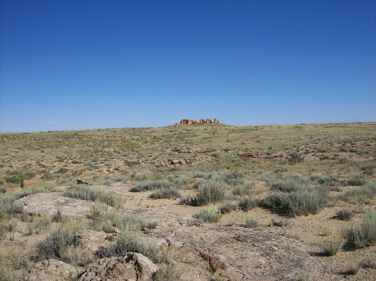
One tantalizing hint comes from the so-called “Sun Dagger” site located on the magnificent outcrop known as Fajada Butte. Rising hundreds of feet from the floor of the canyon, the butte can be seen from over 20 miles away on clear days.
Though climbing it is prohibited to visitors, on its upper slopes archeologists have found three enormous slabs of rock carefully placed so that at each of the solstices and the equinoxes, sunlight moving through a slit in the rock is cast in various patterns on a spiral sun symbol, one of them knife-shaped.
Moreover, a number of the ancient pueblos have central features that seem to be aligned toward positions where the sun rises at various times of the year, evoking Stonehenge.
Combined with other things hinted at in Chaco, it raises the possibility that the canyon might have been occupied briefly for trade and religious rituals at specified times of the year and then stood largely empty for long periods.
But one looks at all of that has been written about Chaco Canyon and sees the words “suggestive of,” “possibility,” “perhaps,” “hints at,” “could have,” “might have” — and realizes that there is much that is unknown, and that may never be known, about this and other sites of the ancient pueblo people.
They did not have a written language, and all that is known about them has been passed down orally from one generation to the next by tribal elders. And, one-thousand years is a long time for historic events to become legend and then myth.
Mysteries of Chaco
Perhaps the most daunting question that arises when dealing with the Anasazi is why all of their meticulously constructed buildings were abandoned starting in the 1200s.
Tree rings record the onset of an extensive drought — but in addition to the fact that severe droughts are cyclical in the Southwest, this would hardly explain the apparent sudden abandonment of the ancient structures. All the signs indicate that at Chaco, Mesa Verde, Canyon de Chelley, and elsewhere, a time came in which the people simply grabbed whatever they could carry, damaged or destroyed what they could not take with them, and vanished into the deserts.
One particular ruin called Chetro Ketl at Chaco shows a change that can be seen elsewhere in the canyon and in many other Anasazi sites: There is an imposing colonnaded wall of a building that resembles features found in Mayan buildings far to the south in Mexico and was perhaps inspired by them. But the spaces between the columns have been walled up. And, as one explores the other ruins both on the canyon floor and on the mesas above it, one sees this process repeated: windows and doorways that have been subsequently filled with masonry.
Was this done simply for the purpose of strengthening the structures? Or combined with other unsettling facts about the ancient people, does it suggest an increasing need for security from attackers? Add these to the unanswered questions about Chaco.
Hike reveals more to ponder
One morning before the heat of midday came, along with a friend from Colorado, I set off to hike the plateau on the west side of the canyon. Carried on the dry morning wind were the combined smells of sage and juniper — what some have termed “desert incense.”
Our goal was the ruin called Tsin Kletsin, which lay at the end of a mile-and-a-half trail that led steeply at first up a series of switchbacks on some jagged cliffs and then over a much gentler slope dotted with Pinyon pines and juniper trees. The only animal life we observed consisted of some buzzards circling overhead — perhaps they were hoping we would be their next meal — and a rather emaciated-looking jack rabbit. We were glad we did not have to depend on wild game for meals.
For whatever reason, Chaco Canyon was nearly empty of visitors that day and we were the only hikers. The landscape below us was — as is most of Chaco — starkly beautiful, with tawny-colored cliffs, enormous piles of talus at their bases, and great embayments in the mesas, in which were nestled many of the ancient ruins.
But Tsin Kletsin was built at the high point of a dusty, windy stretch of desert, its fallen walls brooding darkly against the deep blue sky.
Like many of the other ruins, much of it is still unexcavated, with only a few of the remaining tiers of rock visible to give a sense of its general outline: rectangles and squares, covering thousands of square feet, and the inevitable circular kivas, all of them filled with shallow layers of dirt deposited over the centuries.
In places, small fragments of the Anasazi people’s distinctive black-on-white pottery lay amid the debris on the ground. The stone walls were surrounded by miles of parched landscape dotted with sage and cactuses and occasional junipers or Pinyon pines, some of them long dead and picturesquely twisted and blackened.
And it was there that another of the mysteries of Chaco struck us: Where did the builders get all of the stone to build Tsin Kletsin and some of the other ruins high on the mesas?
The pueblos on the canyon floor required enormous amounts of manpower, but at least the builders’ materials were lying everywhere at the base of the cliffs. But both Tsin Kletsin and a neighbor called Pueblo Alto on the distant north plateau lie a mile and a half from an easily available stone source.
What political or religious ideal could have driven the ancient workers to carry to this remote location the thousands of tons of stone required to raise these buildings? Yet another bewildering point to ponder.
Deep, dark skies
Chaco Canyon has always been known also as a place for lovers of the night sky, and, on Aug. 28, the International Dark Skies Association designated Chaco as the newest Dark Sky Park — a place where a viewer can get away from all artificial light and see the stars as our ancestors saw them.
The nights we camped in Chaco’s rather primitive campground we saw those fiery, cloud-flecked sunsets for which the West is celebrated, and we watched as the sky turned deep azure, then violet, and finally a black unblemished by the haze of cities or the humidity of other climates. Within it, the stars blazed brilliantly, showing shades of red and amber and blue.
The campground is situated close to Chaco Canyon’s north plateau, and at its foot are the ruins of two of the few actual cliff dwellings at Chaco. They are small, no more than fifteen feet square, and they are empty and dusty.
But their walls reflect the pale light of the stars and somehow in the night the tiny pueblos seem to be of this time and not ancient: Through their dark window holes, one expects to see the glow of a cook fire.
But it does not appear.
From the plateau above come the occasional howl of coyotes and the cool evening air is scented with sage and other desert plants; then the realization comes that one is experiencing the sights and the sounds and the smells of night just as the Anasazi did a thousand years ago.
And what had drawn them here? And where and why did they go? And what thoughts entered their minds when they looked up at the gleaming stars?
These and so many other questions frame the haunting mysteries of Chaco Canyon.

The Enterprise — Mike Nardacci
An outcrop of Onondaga limestone can be found along Route 102 with a small shelter at its base. It is apparently an erosional remnant of the layers that covered this area millions of years ago.
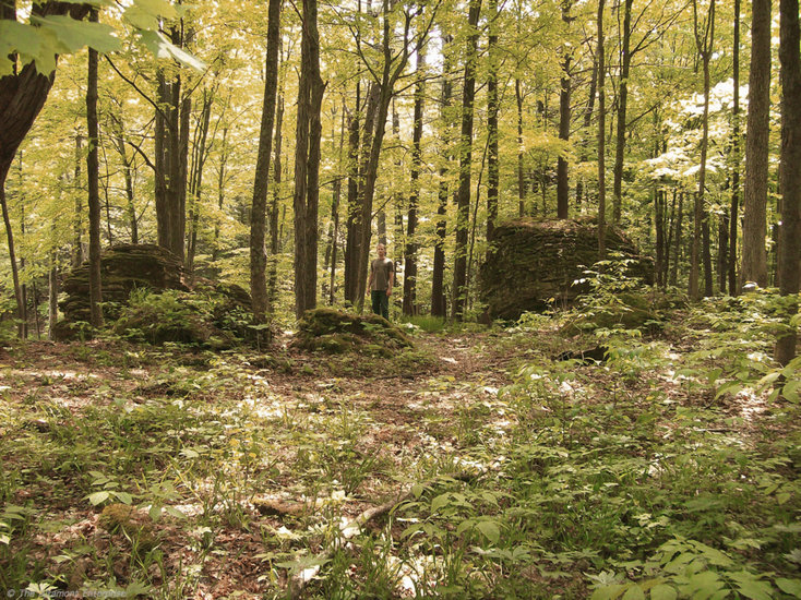
The Enterprise — Mike Nardacci
A section of woods in Joralemon Park shows enormous isolated blocks of limestone randomly scattered. (A Hudson Valley Community College student appears in these photos for scale.)
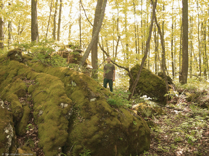
The Enterprise — Mike Nardacci
These blocks are tilted in many directions, indicating they have been displaced from their original horizontal positions.
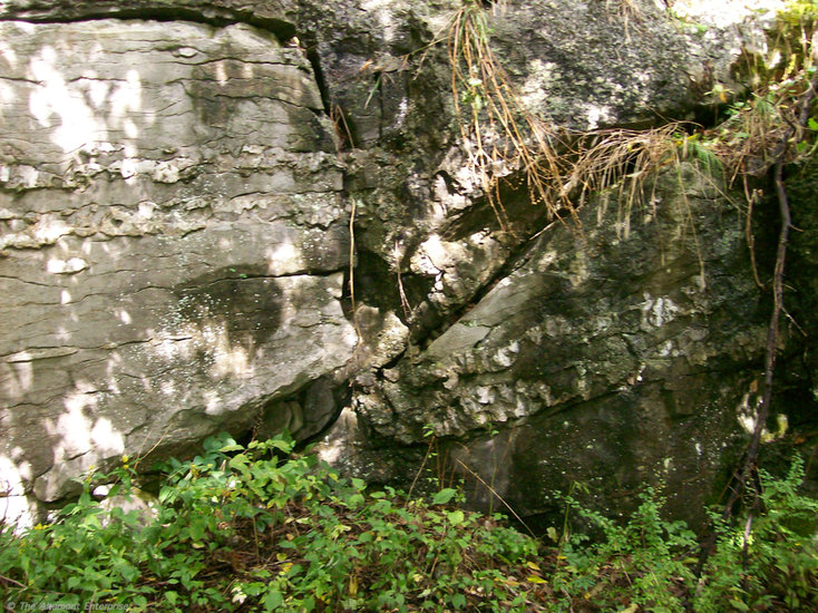
The Enterprise — Mike Nardacci
A textbook fault in a small limestone bluff in Joralemon Park shows two parallel layers of the rock known as “chert” within the limestone have been displaced by the fault’s movement. The layers on the left have been moved upward while those on the right have moved downward.
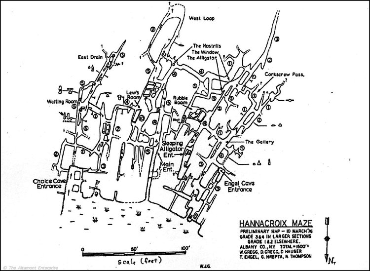
— Map courtesy of the National Speleological Society
Hannacroix Maze, a maze cave in Joralemon Park, near Ravena, was formed by chemical weathering.
An old joke among people whose life interest is rocks is that, if you ask 10 geologists the reasons for an unexplained geologic phenomenon, you will get 10 different answers. Some of the answers will be stated with qualifications while some will be issued with Biblical certainty, and, as some of the explanations will be mutually exclusive, they may set off lively — even bitter — debates.
The wooded areas along Route 102 in Ravena — and in particular, Joralemon Park — have been known to geologists for decades as places of considerable geologic interest.
Among the area’s features are stretches of bare bedrock showing scratches from the passage of glaciers thousands of years ago; a series of easily visible faults produced by very ancient earthquakes; remnants of ancient caves; complex systems of active caves that have yet to be fully explored; sinkholes and karst ponds into which surface waters disappear or from which they emerge; isolated outcrops of 400-million-year-old Paleozoic bedrock, remainders of once-extensive layers deposited in pre-historic oceans; and massive boulders, some scattered randomly through the woods and offering no immediate clues to the reason for their presence.
Rocks, of course, do not simply appear out of nowhere. In mountainous areas, rocky sediments of all sizes weather and erode out of the exposed bedrock. In wide, flat areas far from mountains — such as large stretches of the Hudson Valley and much of the Northeast — rocks must be carried and deposited by streams or glaciers.
The rocks that turn up in farmers’ fields with the maddening frequency of weeds were deposited there thousands of years ago either directly by glacial ice or by the streams that poured from them when they began to melt.
In his great poem, “Mending Wall,” Robert Frost described such rocks found in the stone walls of New England: “And some are loaves and some so nearly balls/ We have to use a spell to make them balance:/ ‘Stay where you are until our backs are turned!’”
The important facts are that erosion by glaciers tends to take the sharp edge off of transported rocks while running water tends to make them more or less rounded; and that glacially deposited rocks are usually “erratics”: specimens of rock types that are not found locally and have often been brought from hundreds of miles away.
And so the Helderberg landscape is dotted with purple sandstone cobbles from Potsdam, rounded fragments of granite and anorthosite from New York’s High Peaks, and chunks of garnet-bearing metamorphic rock from the North Creek area. These sediments are referred to as “glacial drift” deposits and they cover much of the landscape of the Northeast.
Mystery outcrops
And herein lie the puzzles of the Ravena rocks.
A mile or two north of the park, on Route 102, is a massive outcrop of rock that stands alone, looking to be more appropriate to some desert landscape of the Southwest than New York State. It is made of the 400-million-year-old Onondaga limestone, as is much of the surface rock of Joralemon Park, and local lore has it that Native American Indian artifacts were found long ago in the shelter on its north side.
Certainly, it would be an inviting place to spend a rainy night for a hunting party. Its layers lie horizontally on the surrounding terrain — it does not show the disturbance geologists call “displacement.” Moreover, its edges are rather jagged, not blunted; hence, it is unlikely to have been deposited there by a glacier.
While extensive excavation around it would be necessary to make a certain judgment, it is very likely an erosional remnant, a lone remainder of the thick layers of Onondaga limestone that millions of years ago covered the Joralemon area. There are other, smaller such outcrops scattered through the forest.
The massive outcrop is, in other words, likely to be “in place“ as geologists would say. The eponymously-named Joralemon Cave — its entrance yawns on the east side of Route 102 — is located in just such an erosional remnant, a segment of a long-vanished cave system.
The heavily-shaded interior of Joralemon Park contains numerous seeps and springs and swampy areas scattered beneath a forest of tall hardwood trees that trap much of the moisture. This creates an environment evocative of a rain forest, highly conducive to the growth of moisture-loving plants, which are remarkably diverse and prolific in the park.
A few hundred feet into the woods north of the bluff containing Joralemon Cave is an impressive high mound of giant boulders of Onondaga limestone. Its provenance is not so easily determined.
The boulders are wonderful to walk among in early spring and late fall — those times of the year when little growth is occurring, for they contain a collection of various types of mosses and ferns growing on and between them that would be damaged by foot traffic and that would delight any pteridologist or cryptogamic botanist (and yes- — I had to look up the terms!).
They are a spectacular place for children to play hide-and-seek or to imagine the boulders as the ramparts of a castle. Often 10 feet or more on a side, they contain between them innumerable overhangs and shady fractures and passageways, leading upwards or down, hiding places for toads and newts and the occasional black racer — a harmless but intimidating snake that in the Joralemon area can reach a length of six feet.
What is problematic about the boulders is that they are not horizontal to the surrounding bedrock. They are tilted or even upended as if piled there by a deranged giant.
Moreover, the tilts — what geologists call the “dip” of the rocks — are not uniform: One tilts north, its neighbor tilts south, and surrounding boulders may dip toward all the cardinal and ordinal directions on the compass.
Normally, in such a confusing display, a geologist would look on the rocks for “slickensides” — lines gouged into the bedrock when the two sides of a fault move, much as two cars scraping one another in opposite directions would scratch the surfaces. There are a number of such faults visible in exposed bedrock in Joralemon Park, evidence of one or more of the massive, earthquake-producing plate-tectonic events known as “orogenies” that have affected this part of the continent over the last 400 million years.
One of them is worthy of a geology textbook. But, as the boulders are covered in mosses, ferns, algae and liverworts, the slickensides — if they are there — are either obscured by the luxuriant plant growth or have been weathered away by it.
The point is that faults move massive amounts of bedrock during an earthquake. They may displace the rocks on one side of a fault upward relative to the opposite side or they may move them down; they may slide them sideways relative to each other or one side may dive under the other; and they are capable of distorting the rock structure in ways that have geologists scratching their heads trying to figure out just what Mother Nature was up to.
Amazing maze caves
A glance at a map of the active cave system in Joralemon Park may offer a clue.
Known as Hannacroix Maze (its waters feed the Hannacroix Creek), the cave is a true maze. If the prospect of getting lost within its labyrinth were not sufficient to intimidate explorers, the fact that it drains an adjacent beaver pond and is filled with fetid water inhabited by an assortment of creepy crawlers and swimmers usually does the trick.
Maze caves form in places where carbonate bedrock such as limestone or marble is heavily laced with the fractures known to geologists as “joints.” When waters containing mild natural acids — carbonic acid is common — enter the cave in times of flooding, the acidic solution is injected under pressure into every available crack and crevice, and voila! Chemical weathering forms a cave with a maze pattern.
One can easily notice, however, that between the cave passages are angular areas of bedrock. Should erosion eventually remove the roof of the cave, the result would be a rocky ramble such as the famous “Devil’s Den” in the Gettysburg Battlefield.
The “Devil’s Den” is made of igneous rock, not limestone, and the outcrops do not show displacement, so the situations are not exactly parallel. Still, both the cave and the battlefield outcrop represent bedrock in which erosion has occurred on the numerous joints the rock contains, resulting in a maze.
And so it would appear that the great rock pile in Joralemon Park must have resulted from the pre-historic movement of a series of faults running through a massive outcrop of limestone, eventually causing the weathered blocks to be left scattered helter-skelter in the forest.
Or so it would seem.
And yet — there are geologists who will defend the notion that the rocks are indeed glacially deposited — and that the reason that they consist of the same bedrock as the rest of the park and show little of the blunting that would result from glacial erosion is that they just have not been carried very far from their point of origin.
Perhaps it does not matter.
For the fact is that, within the wilds of Joralemon Park, lies a misty forest where water springs mysteriously from the bedrock; where marvelously diverse, unusual plants cover, it seems, every square inch of ground; and where Mother Nature shows her sleight-of-hand in strange geologic phenomena, through the agents of tectonics and weathering and erosion, over time beyond human comprehension.