Driving Route 85: Seeing 450 million years of geologic history
— Photo by Mike Nardacci
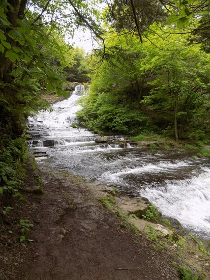
The impressive Rensselaerville Falls formed when Ten-Mile Creek cut a canyon into shale and sandstone layers, following an ancient fault line.
There are places in the world and within the United States in which layers of rock — called strata — record hundreds of millions of years of Earth’s history and are stacked atop one another like textbooks in geology, waiting to be read by the geologically literate. Undoubtedly the most famous is the Grand Canyon into which trails descend, traversing around 2 billion years of our planet’s past along paths less than 10 miles in length.
In Albany County, Route 85 departs Interstate 90 and heads southwest, terminating in the historic village of Rensselaerville and as it skirts Albany and rises into the fastness of the Helderbergs it yields evidence of the last great Ice Age, the collision of continents that formed the Appalachian Mountains, and of the proliferation of ancient life-forms during the Devonian Period, straddling 450 million years of geologic time in 30 scenic miles.
This essay presents a guide to some of the most notable features in a drive that, even allowing for stops, can easily be undertaken in an afternoon — preferably on a clear one so that the occasional stunning long-distance views will not be obscured by our area’s notoriously unpredictable weather, which seems to have been especially fickle in recent weeks.
Setting the odometer at “0” as one’s vehicle leaves Interstate 90 onto Route 85 — for the next few miles a divided highway — one will almost immediately be passing by the extensive complex of New York State office buildings that rise between Washington and Western avenues and farther to the west the towers of the University at Albany will be visible.
The buildings are constructed on a thick layer of sand that is conducive to the growth of pitch pines and earned the area the name “Pine Hills.” What most of the area’s residents are undoubtedly not aware of is the fact that some 10,000 years ago this stretch was lake-front property.
The last great advance of the Pleistocene glaciers ended about 20,000 years ago and after a brief stasis the great melting began as Earth underwent an extended period of warming. Just as no one is sure why the Ice Ages occurred (aside from the general fact that Earth got colder), scientists are unsure what caused the steep and steady rise in temperatures. But rise they did and, due to the warming, the Mohawk and Hudson rivers carried vastly greater amounts of water than they do now.
For reasons also unknown, a blockage occurred in the Hudson Valley somewhere south of Kingston forming a great body of water known as Glacial Lake Albany that filled the valley from the natural dam clear up to Lake George.
Many of the hundreds of streams that fed into the lake formed sandy deltas that combined to form one great shoreline upon which the Adirondack Northway and Route 9 roll north — and upon which this stretch of Route 85 heads southwest. Subsequently, the wind blew the sand into vast dunes and the crescent-moon shape of some of them can still be seen in the parts of the Pine Bush Preserve.

A "restored" section of the Pine Bush Preserve gives an approximation of the appearance of the area following the melting of the glaciers some 12,000 years ago when the stretch was part of the shoreline of Glacial Lake Albany.
Over time, great forests of pitch pine and patches of scrub oak and blueberry grew among them. Parts of the preserve that are undergoing restoration give an idea of the appearance of the sandy stretches thousands of years ago. But given Mother Nature’s prolific ability to reclaim empty growing spaces it will be interesting to see how long the areas currently being “restored” through the cutting of thousands of invasive species such as black locust trees will retain their resemblance to the ancient wind-swept dunes.
Areas “restored” only a few years ago already are green with great quantities of invasive plants, hiding the dune fields under newly-grown foliage. Ecologists call areas such as these “pine barrens,” and the sandy expanses stretching north from Albany County in many ways resemble the great barrens of New Jersey.
Farther to the east was the lake bottom upon which the smaller sediments carried by the streams were deposited, and this is why much of the city and in particular downtown Albany are built on massive layers of clay. In the 1800s and early 1900s, foundries used the clay to make bricks — hence the explanation for why so many older buildings in downtown Albany and Troy are constructed from them.
The extensive areas of both clay and sand in most places obscure the bedrock that lies buried deeply beneath them. It is a dark, thin-bedded shale that dates from the Ordovician Period, making it about 450 million years old. It is visible in a few outcrops bordering the Hudson River. One such outcrop is exposed on both sides of Interstate 90 as it descends toward the Hudson and passes under Henry Johnson Boulevard.

The Upper Gorge of the Onesquethaw Creek shows where the creek has cut deeply into layers of Devonian-age shales and sandstones.
At mile 4.0, Route 85 crosses the Normanskill where the stream slices through the dunes as it flows toward the Hudson. Some years ago, it undercut its sandy banks setting off a massive landslide in this area, causing the stream to permanently re-route itself.
After another couple of miles and several roundabouts, Route 85 joins New Scotland Road and between miles 5 and 6 passes through the historic stretch of Slingerlands reminiscent of New England. The terrain beyond here is mostly flat, rising gently to the west and represents what must have been relatively shallow waters of Glacial Lake Albany.
Geologists estimate that the shoreline extended roughly to what is now the intersection of routes 85 and 85A at the Stonewell Shopping plaza in the town of New Scotland.

Helderberg Country
It is at this point that Route 85 enters what I have always thought of as “Helderberg Country”: a landscape of agricultural fields, deciduous forests, scattered tiny villages, craggy outcrops of bedrock, and sweeping views of the massive escarpments.
Beyond the intersection of routes 85 and 85A, the surface material is a mixture of soils such as clay and sand and larger particles: semi-rounded pebbles, cobbles, and boulders, many of them eroded from bedrock tens or hundreds of miles to the north. Geologists call sediments such as these “glacial drift.” They were deposited directly by the great mass of glacial ice that buried this area thousands of feet deep at the height of the last advance, some 20,000 years ago.
At 8.2 miles, Route 85 passes the historic New Scotland Presbyterian Church, the cemetery of which entombs Winifred Goldring who in the first half of the 20th Century was the New York State Paleontologist; her meticulously-researched publication, “The Geology of the Berne Quadrangle,” with its accompanying beautifully-drawn stratigraphic map has long been a valuable resource for students of Helderberg geology.
At mile 10.7, Route 85 passes the site of the old Indian Ladder Drive-In Theater with its miniature golf course — gone these many years — and offers, in clear weather, an enticing view of the Helderberg escarpment stretching to the north. Shortly beyond the site, there is an exposure of bedrock in a road-cut on the left side of the road; in much of this area north and south of Route 85, these alternating layers of Ordovician-age shale and sandstone known as the “Indian Ladder Beds” are obscured beneath glacial drift or heaps of stone called “talus” eroded from the cliffs of the escarpment.
At mile 11.5, after passing through the hamlet of New Salem, the highway begins the steep ascent that takes it from one Landscape Region — the Hudson-Mohawk Lowlands — to another, the Allegheny Plateau.
Considering the shortness and steepness of the ascent, this is one of the most dramatic changes in landscape regions in the continental United States.
Though the region is locally called the Helderberg Mountains, geologists see it as well as the Catskills to the south as a vast eroded plateau, given that the rock layers that compose it are relatively horizontal and undeformed (except for some minor faulting visible in many areas in Albany County).
The great Allegheny Plateau — also known as the Appalachian — stretches from just west of Altamont south to Alabama and it was formed during the Alleghanian Orogeny; this was an episode of mountain-building that occurred around 290 million years ago, when the ancient landmass that would someday be known as Africa collided with ancient North America.
For a simplified visualization of this event, think of what happens when two cars in a parking lot crash into each other nose-to-nose: The hoods and engine blocks of the cars may be crushed and compacted and pushed upwards, but the rear parts of the cars may be only slightly warped and lifted up above the chassis.
During the Alleghanian Orogeny, the area to the east of us was crushed and elevated into the great chain of mountains that stretches south from New England. The rock within was folded, faulted, raised to great heights, and in many places turned into metamorphic rock; the land farther west was elevated but remained largely undeformed and became the Allegheny (or Appalachian) Plateau.

At the top of the hill, Route 157 cuts right and heads toward Thacher Park. Route 85 continues along a flat lower section of the plateau, offering on clear days broad views across and up the Hudson Valley to three mountain ranges: in the far north, the Adirondacks near Lake George; to the northeast, the Green Mountains in Vermont; and to the east, the Berkshires in Massachusetts — these latter two are actually the same range with different names. Farther to the south in New York State, they are known as the Taconics.
Following the westward curve of the landscape contours, the road passes outcrops of dark shale before descending slightly to the wide valley of the Onesquethaw Creek at 13.7 miles. In the creek bed is exposed the Onondaga limestone, the uppermost layer of limestone in the Helderberg area.
The Onesquethaw drains nearby Helderberg Lake, but in dry times of the year it may flow invisibly under the heavily-fissured rocky creek bed as the Onondaga limestone is a major former of caves. The nearby Clarksville Cave and Onesquethaw Cave among many others are dissolved from the Onondaga.
Devonian-period fossils
In times of rapid snowmelt or unusually heavy precipitation, the creek flows above ground, forming swirling rapids in this stretch. A clean light-gray limestone formed in a long-vanished warm, tropical sea, the Onondaga is studded with beautifully-preserved Devonian-period fossils including numerous corals and shellfish.
Beyond the creek bed, Route 85 briefly joins Route 443 and heads on a shoulder of the valley steeply uphill. Here the bedrock consists of alternating beds of thinly-bedded shale and thick layers of dark sandstone, and these strata extend south through the Catskills.
While the lower-elevation layers exhibit marine fossils — trilobites and clam-like brachiopods, among others — the higher-elevation layers near Gilboa and elsewhere south of the Helderbergs show fossils of primitive land plants and giant fern trees that obviously grew above water.
These layers are the eroded remains of what geologists term the “Catskill Delta.” The name is somewhat misleading for there were numerous deltas that formed and co-joined during the Acadian Orogeny, a period of mountain formation that occurred during the late Devonian Period as North America collided with that section of the primitive European continent known to geologists as Avalon.
Towering, snow-capped mountains rose that were as grand in their day as the Rockies. Rushing streams poured from their flanks, carrying heavy loads of dark sand, clay, and mud, filling in the shallow sea in which the Onondaga limestone formed and producing deposits thousands of feet thick that would eventually be elevated by tectonic action into the Allegheny Plateau.
There are numerous outcrops visible in the Helderbergs in which the dark shale layers sit directly atop the light-gray limestone — compelling evidence of the rise of the great mountains to the northeast.
At 15.8 miles, there is a pull-off on the right side of the highway allowing a glimpse into the deep gorge that the Onesquethaw Creek has formed at the south end of Helderberg Lake. A mini-version of Ausable Chasm, the gorge features rapids, waterfalls, plunge pools, and numerous traces of the movement of small faults and the folding of the rock layers that probably occurred during the Alleghanian Orogeny.
In the gorge, the Onesquethaw Creek provides an example of what geologists call an “under-fit” stream. The deep gorge shows signs of having been eroded by a stream with far more power than the Onesquethaw shows today, but at the time of the melting of the glaciers the ancient Onesquethaw must have been a veritable torrent and its surging, sediment-laden waters would have had sufficient energy to cut deeply into the bedrock, forming the steep-walled canyon visible today. It should be noted however that the gorge is on private property and permission from its landowners must be secured for entry.
At 16.4 miles, there is a view of privately-owned Helderberg Lake to the right of the highway; to the left are road-cuts through the shale/sandstone strata showing their thin layering and fragmentation.
Shortly beyond this point, Route 443 veers west toward Schoharie and Route 85 continues in a southwest direction, moving into a region of fields and forests. Meandering across the landscape are numerous stone walls made both of flat, angular chunks of the local stone and occasional smoothed or rounded boulders; these are “glacial erratics” — transported sometimes hundreds of miles from the Adirondacks or even Canada by the ancient glaciers and shaped by grinding against other rocks in the ice or in the streams that poured from the glaciers in summer.
Robert Frost found these rocks annoying in his famous poem “Mending Wall” as their rounded shapes make them resistant to stacking and easily susceptible to the pull of gravity. The fields here as in the town of New Scotland are buried deeply in glacial drift; clearing these fields first of trees and then of the larger rocks in the soil for farming in the days of the pioneers must have been an appalling challenge.
At mile 24.4, a high glacially-sculpted hill appears prominently on the left side of the road. Like Bennett and Countryman hills near Clarksville, it exhibits a fairly steep north face, a flattened top, and a long, gentle slope to its south face — features of what geologists call a “rock drumlin.”
Fantastical village
At mile 26.9, Route 85 terminates at a T-intersection in the hamlet of Rensselaerville, a diminutive hamlet that very few residents of the city of Albany seem to be aware of — and those who have heard the name almost inevitably confuse it with the city of Rensselaer.
With its steeply sloping streets, its historic buildings, churches, and cemetery, its tiny art gallery and elegant eatery, and the town-wide echo of flowing water from Ten-Mile Creek, the hamlet’s ambience evokes that of Harper’s Ferry in West Virginia — or to the more romantic-minded, the fantastical village of Brigadoon.
Taking a right at the T-intersection and ascending steeply to the west end of the village past the restored mill, one soon enters the Huyck Preserve.
The Preserve consists of over 2,000 acres of forest and includes Lake Myosotis, a wilderness lake that can be accessed both by foot or by car. A trail begins at the west end of the small parking lot and heads upstream along Tenmile Creek.
Almost at once, hikers will hear the sound of falling water. The trail crosses a bridge near the mossy ruins of a 19th-Century mill and offers the first tantalizing view of the Rensselaerville Falls. Just beyond the bridge, a trail cuts sharply to the right and upward and follows a somewhat exposed ledge.
The trail is comfortably wide here though to the right there is a drop ranging between 20 and 30 feet down to the water and hikers should proceed with care. After a couple of hundred feet, one arrives at a ledge approximately one-third of the way above the base of the falls, offering a stunning view of the waterfall.
Here the thin-bedded shale and massive sandstone layers have been incised by Tenmile Creek following a fault that has sliced through the rock layers creating a box canyon into which the overflow from Myosotis Lake plunges 125 feet down a series of step-like projections. The erosive effects of water and ice have caused large, angular boulders to break from the bedrock, creating lacy meanderings and cascades for the rushing waters.
At the bottom of the falls is a plunge pool bordered by flat shelves of the dark shale, and a sharp-eyed observer may see in some of the exposures wide ripple marks: evidence of the shallowing of the ancient waters in which the sediments were deposited by streams rushing from the high mountains rising to the northeast during the Acadian Orogeny.
Soon those deposits would form the so-called Catskill Delta on which primitive ancient plants including fern trees would grow. Millions of years later, the violent events associated with the Alleghanian Orogeny would elevate the layers far above sea level and perhaps cause the fault through which Tenmile Creek would begin its spectacular plunge toward the sea.
I have always taught my students that, to appreciate geologic history, one must have a good imagination. Driving on Route 85, one begins on the sands of the immense delta that bordered Glacial Lake Albany some 10,000 years ago — a time which, to a geologist, is not much further back than yesterday morning.
But along the highway lies evidence of ancient seas, the rise and fall of great mountain chains, the effects of millions of years of weathering and erosion, and the more recent, Earth-altering events of the last great Ice Age. There are few places in the continental United States where so much geologic history is revealed — and so easily accessible. For those with the inclination and imagination, the chronicles of worlds forever lost and gone lie almost literally in our backyard.