Village plan recommends spending over $3M for safer streets
The Enterprise — Melissa Hale-Spencer
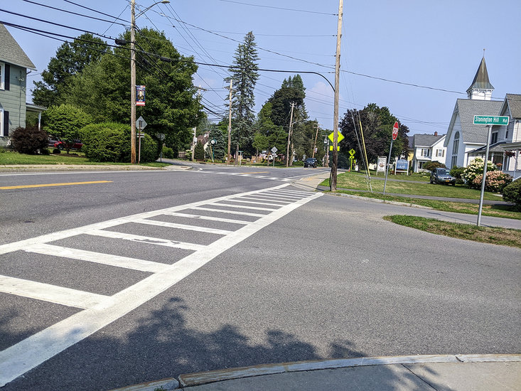
Voorheesville’s Safe Streets Policy and Plan proposes a redesign of the intersection of Route 85A, Voorheesville Avenue, and Stonington Hill Road. The proposed design would correct the intersection’s geometry, changing Voorheesville Avenue’s angle to meet Maple Avenue to 90 degrees to improve visibility and alleviate gridlock.
VOORHEESVILLE — The village is in the process of drafting a plan to guide development of its streets, sidewalks, and bridges. Recommended improvements would cost close to $3.4 million to be paid for through a combination of federal and state grants and village funds.
Voorheesville’s Safe Streets Policy and Plan “aims to assess the existing transportation system and identify concept improvements to enhance multimodal safety, accessibility, and connectivity across the Village.”
Specifically, the study seeks to:
— Identify key safety concerns throughout the village’s street network.
A survey of villagers included as part of the plan reveals one of residents’ chief safety concerns is residents themselves, specifically driver behavior, characterized by excessive speeds and not following traffic laws.
Residents report that drivers often “fly through” major corridors like Maple Avenue, reaching speeds of 45 to 50 miles per hour in posted 20- to 30-mph zones, particularly near the elementary school. This issue is compounded by the frequent failure of drivers to yield to pedestrians at crosswalks, the report said, a problem residents feel is exacerbated by a lack of consistent traffic enforcement.
An analysis of crash data showed crashes involving a bicyclist or pedestrian accounted for nearly half of all crash-related injuries, the report said, but represented a small fraction of total crashes.
The crashes “tend to concentrate on the Priority Streets owned and maintained by the County or New York State,” the report said, including:
— The intersection of Stonington Hill Road, Route-85A, and Voorheesville Avenue;
— Route 85A between Swift Road and Mountainview Street adjacent to Voorheesville Elementary School;
— The intersection of South Main Street and Prospect Street adjacent to the Helderberg-Hudson Rail Trail trailhead; and
— Route 85A between Pine Street and the roundabout.
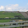
Between 2019 and 2023, the report also notes at least five incidents of freight trucks striking CSX’s low-clearance bridge running over Maple Avenue. These collisions create traffic backups and force oversized vehicles onto other local roads, the report states, presenting an ongoing and distinct safety challenge that requires a targeted solution.
The dangers are magnified by widespread deficiencies in the village’s pedestrian infrastructure, the report states, since many residential streets lack sidewalks entirely, forcing people to share the road with vehicles.
And where sidewalks do exist, they’re often fragmented or present significant accessibility barriers, the report said, citing as an example, the sidewalk under the CSX railroad bridge on Maple Avenue being less than three feet wide, making it impassable for many mobility devices. Elsewhere, utility poles, mailboxes, and signs are situated directly in the walkway.
The report also noted that the public transit system has suffered from similar neglect, with most stops marked only by a sign and lacking basic amenities like shelters, benches, or lighting;
— Address transportation needs by providing specific improvements for priority streets Maple Avenue, Voorheesville Avenue, and South Main Street.
Conceptual design interventions proposed for the Maple Avenue mid-block crossing at Jim Nichols Memorial Park include curb extensions, pedestrian-scale lighting, and high-visibility crosswalk paint to improve visibility and to slow traffic.
Rectangular rapid flashing beacons and a raised crosswalk are also suggested, pending state approval. Other improvements include shared roadway markings for bicyclists, street furniture, maps, a Vly Creek viewing area, and new stormwater drainage.
The estimated cost for these improvements is about $708,000.
The proposed redesign of the intersection of Route 85A, Voorheesville Avenue, and Stonington Hill Road would correct the intersection’s geometry, changing Voorheesville Avenue’s angle to meet Maple Avenue to 90 degrees in order to improve visibility and alleviate gridlock.
Proposed changes for the intersection include placing crosswalks closer together with pedestrian-scale lighting, adding “don’t block the box” striping, and creating a pedestrian island on Stonington Hill Road to shorten crossing distances and slow turning traffic.
Enhanced signage for the low CSX bridge is also planned to better warn freight vehicles.
The estimated cost for these improvements is about $822,000.
For South Main Street, the focus is on complying with the Americans with Disabilities Act and creating a more inviting atmosphere. This involves relocating utility poles away from sidewalks and widening sidewalks to accommodate amenities without blocking pedestrian access.
It’s noted that some on-street parking may be removed, but that a new municipal parking lot is planned — at 18 South Main — to increase overall parking capacity.
Aesthetic improvements would include pedestrian-scale lighting and street trees. A high-visibility raised crosswalk with curb bump-outs is recommended at the new municipal parking lot, and gateway improvements — trees, lighting, wayfinding, historic displays — are proposed at the Helderberg-Hudson Rail Trail trailhead to draw visitors to Main Street businesses.
The estimated cost for these improvements is about $1.84 million.
The proposed improvements would be paid for through a combination of various federal and state grants and village funds; and
— Formulate a Complete Streets policy and plan to guide future street design and construction.
The village’s Safe Streets plan centers on adopting a Complete Streets policy as local law, requiring that all road projects accommodate the needs of all users — pedestrians, cyclists, transit riders, motorists, and people of all ages and abilities.
The overarching goal of the Complete Streets policy is to create safe, accessible, and aesthetically appealing “village-scale” streets that encourage walking, biking, and community engagement while connecting key destinations such as parks, the library, and commercial areas.
The policy would apply to all modes of transportation, including active transportation, public transit, and micromobility, with an emphasis on children, older adults, and individuals with disabilities. The policy would cover every phase of a project’s lifecycle, from planning and design to construction, operation, and maintenance, ensuring the development of an integrated transportation network.
Connectivity would be a priority; for example, where sidewalks end, adjacent roads must provide safe pedestrian routes.
Designs would adhere to established best practices and be sensitive to the local context, enhancing the area's character without compromising safety. And while exceptions to the policy would be possible, they’d require a rigorous public approval process by village trustees.
The plan also includes performance measures to track progress and effectiveness, such as annual sidewalk improvements, the number of traffic-calming measures installed, crash statistics — especially those involving vulnerable users — rates of active school travel among children, and the number of traffic violations issued. Continuous monitoring and evaluation are intended to guide improvements, ensuring the policy remains effective in fostering a safe, connected, and welcoming street environment.