Albany County under cold weather advisory Friday night
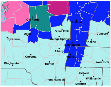
— Map from the National Weather Service
Albany County is colored turquoise, indicating a cold weather advisory. The blue areas are under an extreme cold warning while green indicates a lake-effect snow warning and pink means a winter storm warning.
ALBANY COUNTY — A large, long-duration winter storm is expected to bring widespread heavy snow, sleet, and freezing rain from the Southern Rockies into the Mid-South beginning Friday, spreading eastward to the Mid-Atlantic and New England this weekend, according to the National Weather Service.
At the same time, an Arctic front will bring frigid temperatures and gusty winds that will lead to dangerous wind chills from the Northern Plains and Upper Midwest, the service says.
Albany County will be under a cold weather advisory from 7 p.m. on Friday until 10 a.m. on Saturday.
“The dangerously cold wind chills as low as 25 below zero could cause frostbite on exposed skin in as little as 30 minutes,” the advisory says. “Frostbite and hypothermia will occur if unprotected skin is exposed to these temperatures.”
The weather service advises keeping pets indoors and dressing appropriately with a hat and gloves.
A winter storm watch will be in effect from Sunday morning through Monday evening. Heavy snow, with an accumulation of over seven inches is possible, the weather service says.
Snowfall rates may exceed one inch per hour at times, especially on Sunday night., the weather service says, advising against travel, adding, “Motorists should use extreme caution if travel is absolutely necessary.”
— Melissa Hale-Spencer