Hurricane of 1938 caused catastrophic losses, emotionally as well as financially
— Photo from the Guilderland Historical Society
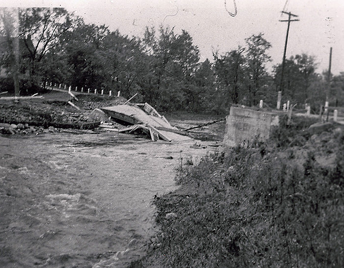
The Becker Bridge, destroyed in 1938, was originally named after the farm family that had lived nearby. Bridges of that name had been in that spot for generations, but this was not the same location of the present bridge over the Bozenkill. In 1939, New York state replaced the old Becker Bridge with a new one in the location on Route 158 we are familiar with today, building a bridge of steel girders 65 feet long and straightening out the road to make it safer.
Overcast early morning skies on Sept. 21, 1938 found Guilderland farmers going about their chores, workers driving to their jobs, local businessmen and professionals opening their stores or offices, and housewives tackling their usual household routines.
Other local folks were out of town. Mr. and Mrs. Walter Fick had left their home in Altamont early with their daughter Ruth driving 210 miles east to Providence, Rhode Island, planning to drop Ruth off at college, then returning home the same day.
Vacationing that week at Orient Point on eastern Long Island was another Altamont family Mr. and Mrs. Frederick McCellan and son.
Also on vacation were Mr. and Mrs. Weidaw, a former WGY announcer with his wife, Margaret Waterman Weidaw, originally of Altamont where her parents still resided on Western Avenue. The couple now lived in Connecticut, but he was still well known in this area. The two were aboard the Cunard luxury liner Carinthia heading to the West Indies.
In the meantime, out in the Atlantic, a Category 5 hurricane had formed, reaching estimated winds of 155 miles per hour. Originally this storm had been predicted by the United States Weather Bureau to lash into southern Florida where people made ready for the storm.
However, the ferocious storm changed course, heading north, passing to the east of the Carolinas, dropping by then to a Category 3 storm with winds from 111 to 129 miles per hour. At that time, radio messages from ship captains were the only way for weather forecasters to track hurricanes.
Categorizing them with numbers based on wind speeds came into being in 1969 when the Saffir-Simpson wind scale was developed. However, in retrospect, modern meteorologists now use these categories to describe the hurricane of 1938.
Normally in 1938 a hurricane would have been expected to curve northeast out to sea, moving away from the cold waters off New England.
Except for Charles Pierce, a young U.S. Weather Bureau weather forecaster who predicted that it would go straight north aiming at New England, all the more senior personnel including the head of the bureau overruled him, opting for the storm’s traditional path out to sea with the result that no hurricane warning went out to the folks in its direct path either on Long Island or in New England or that it was particularly dangerous storm.
The ferocious and unpredicted hurricane made landfall on eastern Long Island in the midafternoon on Sept. 21, 1938, the storm surge coming in with high tide. The area was quickly devastated with beachfront summer cottages washed out to sea or damaged beyond repair by driving rain and hurricane-force winds. Lives were lost.
Crossing Long Island Sound to Connecticut and Rhode Island, the howling winds, flooding from torrential rain, and tidal surges began to cause catastrophic damage and huge loss of life. An observatory south of Boston recorded one wind gust at 186 miles per hour.
Buildings were blown down or severely damaged by wind and water, streams and rivers overflowed, causing irreparable damage in many mill towns where flooding destroyed factories. The power grid was wiped out.
Worst of all was the loss of life. The intensity of the hurricane grew less as it moved into far northern New England, but its effects were felt as far away as Canada and points west to Guilderland and the surrounding Capital District towns and cities in local counties.
In the Capital District that day, the overcast skies darkened and the rain began. By midafternoon, torrents poured down, the rain driven sideways by gale-force winds.
As the hours passed, streams began to rise, and trees began crashing down, blocking roads and taking down electric and telephone wires as they fell. Roads were flooded and sometimes washed out.
Bridges were sometimes washed out as well. Washouts and flooding also occurred along the railroad lines. All this occurred even though the area was 175 miles to the west of the intense hurricane.
Local damage
Two days later, The Enterprise’s lead headline told it all: “Backwash of Tropical Hurricane Rakes Entire Area Wednesday As Floods Wreck Bridges; Crops Down” and “Death Toll In North Atlantic States Mounts Press Reports; Local Sections Are Flooded As Streams Go On Worst Rampage In Quarter Of A Century.”
The writer reported, “Albany was a picture of general misery” but by comparison “damage to property in coastal states [was] beyond calculation.”
After gales described as “mile a minute” accompanied by “blinding sheets of rain” lasted for hours, this area was a “picture of general misery with trees and power lines down and highways flooded” with some bridges out even though the area was distant from the worst of the storm.
An estimate of the rainfall that had come down in the storm and the previous two days in this area was estimated to have been 6.28 inches. Any crops that had been left unharvested were flattened by the howling winds and soaked by the rain for a total loss.
Cellar flooding was common anywhere in town that was near an overflowing stream or in a low-lying area. Particularly hard hit was Altamont where the small streams that run through the village overflowed, flooding cellars and leaving debris all over the village.
Just previous to the storm, Altamont High School had updated the elementary playground and regraded and reseeded the baseball field only to have it ruined by rushing water and strewn with debris. Repairs were estimated to cost $800 ($17,000 in modern dollars), a hefty loss to taxpayers during that Depression year.
More severe local damage occurred when the Becker Bridge on the Altamont-Schenectady Road was washed out by a raging Bozenkill, leaving behind a “wreck of concrete and steel.”
Traffic on main roads was stalled the night of the storm due to flooding or trees down. In some local areas railroad traffic was snarled with flooded tracks or washouts undermining tracks. Waters of the Normanskill were especially high along its length.
Damage and flooding was common not only in Guilderland, but also in surrounding towns and counties. Schenectady County was also affected by damaged roads, bridges, and railroads with trees and power lines down. Crops still in fields were ruined.
Initially Schoharie County was isolated by extensive flooding, bridges down, and road damage. The Hudson River crested at 18 to 19 feet, especially affecting Troy where the state stepped in to provide supplies to aid flood victims.
Appeals were made by the local Red Cross chapter for cash donations to bring aid to the devastated areas battered by the worst of the storm. Their notice in The Enterprise said, “10,000 families are temporarily homeless and under care of the Red Cross.”
Cash only was requested since transportation was so badly affected that shipping food and other supplies was almost impossible. Seeking to raise $4,000, for the next few weeks, local Enterprise columns included the names of Red Cross representatives in various areas of town who would take donations.
In the weeks after the storm Enterprise articles recounted stories of local folks who were caught in the hurricane at its worst. The Ficks, who had left Altamont that morning heading to Providence had gotten within eight miles of the city, having encountered flooded roads, barns down, fallen trees, downed power lines, and being detoured from one roadway to another.
Finally unable to go any further, they spent two hours sitting in the car until things let up enough that they could go into a nearby gas station where they ended up spending the night.
Returning to Altamont, they witnessed that homes had been washed away, while others were submerged in water. Downed trees and power lines and poles along with debris left by the storm clogged roads, snarling traffic. The Ficks arrived back home in Altamont around midnight Thursday, estimating they had covered 600 miles.
Riding out the hurricane at their vacation accommodation at Orient Point, the McClellan family experienced the storm. Mrs. McClellan noted that many substantial summer cottages were washed out to sea, blown down, or submerged by the tide and storm surge.
Nearby the state park was almost barren of standing trees. After the storm passed, the downtown area was underwater with people being rescued from the second floors of their homes. Returning to Altamont on Friday, the McClellans found traffic snarled by downed trees and power lines.
A week later, the tale of the Weidaws wastold. Their luxury liner rode out the full fury of the storm before the winds dropped slightly in intensity to Category 3.
The ship’s captain had changed course to escape the fury of the storm, but the storm also changed course and the Carinthia found itself in the thick of it. His account of the storm had been taken from the Hartford Courier and reprinted in The Enterprise.
With both captain and crew members claiming it had been the worst storm they had ever experienced at sea, most passengers were sea sick and in some cases thrown down by the rolling ship. Once the storm had passed when it was possible to go outside, Mr. Weidaw observed there was much surface damage with covers torn from life boats and one actually torn from its davits. Fortunately, with the skill of the captain handling the ship, no major damage occurred and they arrived safely in Jamaica.
The New York Telephone Company president placed a large ad, which probably ran in many newspapers, thanking the public for its “forbearance” for the time it took to restore service to 50,000 telephone customers in the area from Hudson to Glens Falls. Crews had been called in from Virginia and other states unaffected by the storm. The fallen trees and debris had made their job difficult.
Record-setting
The Hurricane of 1938 — naming hurricanes did not begin until the early 1950s — is still considered the worst weather disaster of the 20th Century in eastern Long Island and New England. The confirmed death toll reached 682, but is believed to be much higher because many victims were washed out to sea with high storm surges.
So extensive was tree loss that the U.S. Forest Service estimated that there had been two billion trees blown down. Losses were suffered by farmers, the fishing industry, small factories in milltowns, owners of the approximate 26,000 automobiles demolished and the estimated 57,000 structures destroyed or damaged, only a small amount of which was covered by insurance.
Losses were catastrophic, emotionally as well as financially. Modern estimates of the losses are in the neighborhood of close to five billion dollars. Fortunately it was a fast moving storm or the flooding would have been worse.
Guilderland and the Capital District got off lightly by comparison, but the unexpected storm caused inconvenience to those with flooded cellars and financial loss to many farmers or for repairs to outages, whether electric, telephone, rail or roads.
Note: Weather buffs might want to read “Sudden Sea: the Great Hurricane of 1938” by R.A. Scott. There are also some interesting websites for the Hurricane of 1938.