Climbing the high ones into thin air
— Photo by Mike Nardacci
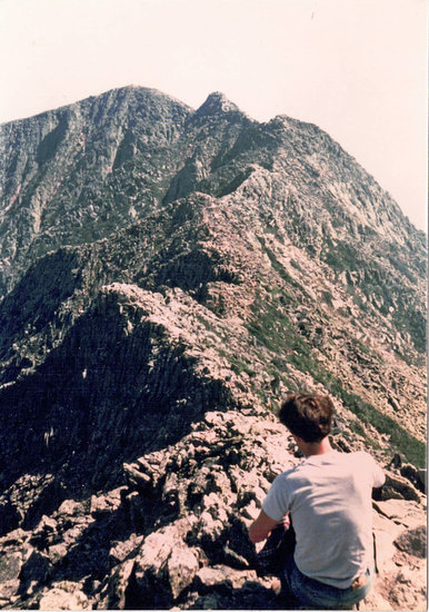
The famous Knife Edge on Maine’s Mount Katahdin was formed when glaciers on opposite sides of the mountain slope carved it into a narrow, perilous ridge.
The goal of every serious mountain climber in the Northeast is to bag the three Big Ones: New York State’s Mount Marcy at 5,344 feet; Maine’s Mount Katahdin with its famous — or infamous —“Knife Edge” at 5,267 feet, and New Hampshire’s magisterial Mount Washington at 6,288 feet with its notoriously changeable weather that has killed more climbers than the other two peaks combined.
Since not one of these is much more than one mile above sea level, in-shape climbers are not likely to be much affected by the drop in air pressure on any of them. However — especially on the summit of Mount Washington — many climbers who carry sealed bags of chips or trail mix will notice that the bags have puffed up and appear ready to explode as air pressure drops noticeably even over that relatively small elevation change.
Mountains generally form through one of two processes: volcanic eruptions and tectonic plate collisions. Many great mountains in the contiguous United States such as mounts Rainier and Hood and Mount St. Helens are active volcanoes formed largely of the light-colored igneous rocks rhyolite and andesite and dark rocks called basalt and gabbro, and are high enough to have glaciers spilling down them.
When they erupt ,as in the devastating Mount St. Helens event in 1980, the glaciers instantly melt and produce catastrophic blasts of boulders, pulverized rock, and searing poison gasses known as pyroclastic flows, which devastate the landscape and bury everything around them in a slurry of hot mud and ash.
On the other hand, many of the high peaks in the Northeast such as Katahdin, Washington, and the other White Mountains, rose millions of years ago when the tectonic plate that would become Africa and Western Europe collided with the plate that would become North America in the event known as the Acadian Orogeny (“orogeny” means a mountain-building episode). The plates were like two 18-wheelers crashing into each other nose-to-nose, crushing and distorting the cabs, trailers, and their freight.
Mountains such as these — once of lofty Himalayan grandeur but torn down by erosion — tend to be composed of igneous rock such as granite and metamorphic rocks such as gneiss and schist. The origin of the Adirondacks — which continue to rise — and the West’s Rocky Mountains, all of them far from tectonic plate boundaries, are geologic mysteries over which geologists contend in sometimes heated debates.
One recent theory holds that far beneath the Adirondacks lies a crustal “hot spot” similar to the one beneath Iceland that millions of years hence may erupt in a series of volcanoes.
In any case, Mount St. Helens tops out at over 10,000 feet along with others in the Cascades and the Rockies, many of which rise to over 14,000 feet. They are not only high enough to have year-round snowfields and glaciers but extend into the upper reaches of the layer of the atmosphere in which we live called the troposphere.
Half of our atmosphere’s weight is packed into the lowest 3 ½ miles; even at 10,000 feet — less than two miles, far higher than any of our eastern peaks — most people will begin to find breathing labored and even the most fit climbers will note the increased effort in ascending, especially with packs.
Attempting Rainier
Some years back, having climbed Washington, Katahdin, and Marcy along with 38 other of New York’s fabled “Forty-Six” peaks over 4,000 feet, I proposed to a friend that we fly to Seattle and join an expedition with a company called “Rainier Mountaineering” to the top of Mount Rainier.
The company offered two-day treks to the mountain’s glacier-encased summit led by highly experienced guides, some of whom had climbed in the Himalayas. We prepared for it as we would for any Eastern peak — running a few miles on alternate days and doing limbering exercises.
But, when we met our companions the day before the start of the expedition, we got a rude awakening. Many of them had spent the previous two weeks in Colorado or California climbing mountains of equal height to Rainier but without the glaciers — and they had carried 40-pound packs.
It turned out that our lead guide was going to be celebrity climber Ed Viesturs, who had just returned from his fifth ascent of Mount Everest — and he had done it without oxygen tanks.
My friend and I gave each other looks that said, “We are seriously in over our heads.” We learned later from his autobiographical book, “No Shortcuts to the Top,” that Viesturs has a lung capacity almost 50 percent greater than that of the average male.
Day One of the trek began at 10 in the morning at the venerable Paradise Lodge at an elevation of 6,000 feet on Rainier. Though the date was July 6, there was close to five feet of tightly-packed snow on the ground, melting rapidly into rushing rivulets and rills beneath the high summer sun.
With 10 companions and the energetic Mr. Viesturs in the lead, we began our ascent of the steep snowfields up a series of switchbacks following red flags on stakes that led to Rainer’s summit.
It was a stunningly beautiful climb. The trail at first wove its way through groves of pines, gradually decreasing in size with altitude but it soon led us above timber line with spectacular views of the gleaming blue and silver glaciers plunging down from Rainier’s summit.
To the south loomed some of the great volcanic peaks of the Cascades — mounts Jefferson and St. Helens — the whole scene under a radiant azure sky that occurs only at high altitudes. And indeed we felt the altitude, especially later in the afternoon as we arrived at Camp Muir, Rainier’s base camp.
Muir is situated at over 10,000 feet on a wind-blasted rocky ridge, perched picturesquely above one of Rainier’s glaciers with a series of dangerous-looking crevasses dropping into shadowy depths. Every step we took had been labored and the desert-dry air induced the need for constant gulping of water from the four canteens we carried.
The plan was for climbers to sleep until midnight and then begin the final ascent to the summit. In summertime, the dark hours are the safer times in which to ascend through the snowfields and over the glaciers, before the high sun can melt masses of snow and set off avalanches.
Most of the party members were too pumped up with adrenaline to sleep and the couple who did snored loudly enough to be heard in Seattle. In any case — word came late in the evening that a storm was brewing just east of the mountain and was expected to hit around 1 a.m. — just when the climbing teams would be heading for the summit and so the climb had to be “turned” as the climbers’ expression has it.
We were offered a second chance to try for the summit later in the summer — but all dates for the next few weeks were fully booked and so with a mixture of disappointment and relief we started down at sunrise.
We felt disappointment because, as we descended, the shimmering snowfields and glaciers against the cobalt-blue sky above Camp Muir were like the Sirens’ call — alluring almost beyond resistance; relief, because we knew we were not up to this challenge.
We were neither acclimated nor in physical shape for climbing above this altitude. Drained and dehydrated, we were sobered by the thought that we would have had nearly 4,000 more feet to ascend — roped together in teams and making our ways with ice axes — in the company of people who were far more fit than we were.
And yet — though our trek on Rainier was terminated, it remains one of the greatest of all my life’s adventures and the memory of those two days on that magnificent mountain is its own success.
Pikes Peak
My next attempt at climbing at high altitudes came a year or so later when, at the invitation of some friends in Colorado, I began taking on the challenge of climbing some of Colorado’s “Fourteeners” — Rocky Mountains higher than 14,000 feet.
The first mountain was going to be Pikes Peak with a massive profile that looms over the city of Colorado Springs. This time, I was determined to be more prepared and spent several days in the city itself getting acclimated to the elevation.
“The Springs” as the locals call it has an elevation of 6,300 feet — a thousand feet higher than the “Mile-high city” of Denver. And the setting is deceptive: Since “the Springs” lies at the base of 14,109-foot Pikes Peak and other high summits of the Rockies that rise like a gigantic wall above the city, the impression is created that its elevation is far lower than it actually is.
Travelers newly-arrived are unnerved to find that simple acts such as carrying a suitcase up a flight of stairs can leave them gasping for breath and their hearts pounding. As it happens, Colorado Springs has a paved running trail that meanders through the city’s outer neighborhoods, bordered by yucca and cactuses and other desert plants; it traverses moderately steep hills, making it an ideal course on which to get acclimated to the elevation.
I did a series of runs in the days before we set out for the mountain and was somewhat intimidated by the effort resulting from the lower oxygen levels.
The most popular trail to Pikes Peak’s summit departs from the neighboring town of Manitou Springs, a 27-mile-round-trip that most people do over two days. With backpacks and walking sticks, we set out early one morning following a series of switchbacks on a well-defined trail that led into the Pikes Peak wilderness.
Pikes Peak and many surrounding mountains are part of what geologists term a batholith — a gigantic mass of igneous rock, in this case a beautiful deep-red granite — that has been pushed forcefully from deep within the Earth.
As it rose, it broke through horizontal layers of russet iron-bearing sandstone, creating the spectacular tilted and sometimes vertical slabs of Denver’s Red Rocks Park and the Garden of the Gods in Colorado Springs. Wind, water, and glacial ice have subsequently sculpted the granite mountains into rugged summits, several of them —Pikes Peak included — high enough to retain snowfields even in the summer.
Our first day’s trek took us up through some wild forests in which mountain lions are known to roam, attacking solitary climbers. But on a summer’s day, “solitude” is not a state to be found anywhere on Pikes Peak and scores if not hundreds of people may be making the ascent — the most intrepid and fit completing the entire round trip in a single day.
We were seldom out of sight of other climbers and their echoing voices frequently distracted from the natural sounds of wind and birdsong in the stunted pines. We camped for the night at a very primitive but crowded campsite just above timberline at around 11,000 feet.
After nightfall, far below us, the lights of Manitou Springs and Colorado Springs were spread out toward the horizon in vast, vertiginous, glittering geometric patterns. High altitudes can inhibit both appetite and sleep, but with over 3,000 feet to ascend the next morning, before sliding into our bedrolls for a night of fitful slumber, we managed to chow down on high-protein food reconstituted with our mini-camp stoves.
To our disappointment, the bright glow of the sprawling cities below tended to dim the light from the stars, which should have been brilliant at that elevation.
We were awakened from a restless sleep at dawn by the voices of literally dozens of other climbers for whom today was “summit day.” Fortunately, the changeable weather of the Front Range Rocky Mountains had given us a clear, dry morning.
We set out for the summit up a seemingly endless series of switchbacks; this meant slow upward progress but it also reduced the effect of the increasingly thinning atmosphere. In less than three hours, we arrived at the top — and were overwhelmed by the crowds.
Like Mount Washington and New York’s Whiteface, Pikes Peak has an auto road to its summit; also like Mount Washington, it has a cog railway to bring up tourists in great numbers.
Some of them looked shaky, seriously affected by the rapid increase in altitude, and were looking for a place to sit down or were quickly returning to the cog railway car in which they had come up. The railroad allowed only 40 minutes on the summit for its passengers and even that was too much time for the unacclimated.
Heart palpitations, headaches, and nausea are common among people who venture into regions of thin air — even sometimes for those who are acclimated.
The sweeping view from the top inspired Katherine Lee Bates to compose “America the Beautiful”: To the east, the Great Plains stretched into the dusty distance; north and south, steep peaks and passes of the Front Range of the Rockies lumbered toward both Wyoming and New Mexico; to the west, rugged summits of the Sawatch Range and the Presidential Peaks receded into a blue haze.
But the noise from crowds and cars overwhelmed the scene, making it more a tourist attraction than a conquered summit, seemingly diminishing our effort to achieve it.
Mounting Massive
But the following summer, at the invitation of one of my former students, I accepted the challenge to climb Mount Massive, an enormous “Fourteener” that rises above the village of Leadville and the Animas River Valley west of Denver.
Massive is an isolated peak with a jagged summit and, like Mount Washington, it is known for its violently changeable weather even in summertime. At 14,421 feet, it is also the second highest mountain in the Rockies, rising a few miles north of Mount Elbert which is the highest.
Pikes Peak and the other soaring Rocky Mountains rose during the Laramide Orogeny, some 80 million years ago. But the rocks of which these mountains are made are far older — metamorphic rocks such as schist and igneous granite from Proterozoic time, some 2.5 billion years in the past.
As the Rockies are far from any tectonic plate boundary, the forces that caused the Laramide Orogeny are — as the saying goes — “not well understood,” but the result was a chain of peaks many of which are over three miles high, and Massive — as its name suggests — is one of the most impressive and challenging.
Our climb began at dawn at the end of a gravel road near the Colorado Trail, which heads south along the base of the Sawatch Range of the Rockies, passing through some very high, remote wilderness. Though it was July and the sky was a clear Colorado azure, the ground and the stunted tree trunks and foliage were covered in frost — common at this elevation even in summer.
We encountered no one else on the trail, but talked loudly and made every attempt to make noise as we walked, wary that these high forests are home to mountain lions and bears known at times to be aggressive. The path to the summit departed west from the Colorado Trail, and soon we were above timberline.
This trail was far different from the gentle switchbacks of Pikes Peak and every step became an effort as the air thinned; steep and sometimes poorly defined, the path reached upward past frost-blasted cliffs and outcrops of gneiss and granite and our footing became treacherous as we made our way over boulders and jagged piles of glacial debris.
Toward noon, what had been a mild morning breeze became a low, menacing wail and gradually the sky was dimming to a featureless gray haze. A rule of climbing in the Rockies is to make summit by 2 p.m. because that is when the high sun can begin to breed storms from rising air currents and experienced climbers will begin their descents.
The top of Mount Massive is not a single point but an undulating plateau of nearly a half square mile with three ragged elevated points, the highest in the middle. We could see the actual summit only a few hundred feet away but in the thin air, even on a now much-gentler gradient it became an effort just to breathe and walk and we settled into a rhythm — 25 steps and a rest; 25 steps and a rest — until we reached the summit cairn lording over a rocky wilderness.
Though the cold wind had risen to an increasingly menacing howl, with our ascent over, it became pleasurable to be able to breathe without feeling we were gasping for oxygen. That climbers — some of them without oxygen canisters — ascend to twice this elevation in the Himalayas into what is called “the Death Zone” in temperatures well below zero was almost unthinkable.
We did not linger after snapping a few photos and headed back down through the stony wastes. The saying goes that a mountain is not climbed until you are down, and the view to the west where Massive’s notorious storms breed had become a deep, dirty gray that was slowly resolving itself into voluminous clouds.
Even at these altitudes, descending is much less taxing than ascending and it was a relief when we dropped below timberline into the Colorado forest. Though we heard a couple of rumbles of thunder as we made our way down from the trailhead and along the Colorado Trail, the full fury of the storm was not unleashed until we had returned to Leadville.
By then, all of Massive had vanished into ominous dark obscurity and when dawn broke the next morning the mountain gleamed under a fresh coating of snow that streamed from the summit in lacy filaments. The prospect of having been caught in that storm was sobering indeed.
Legendary peaks
Over the years I have climbed six more of Colorado’s “Fourteeners,” none of them as daunting as Mount Massive, but each with its own alluring scenery and challenges.
I have also summited a number of peaks in the Canadian Rockies, lower than those in the United States but often still in the grip of extensive glaciers from the last ice age: Rising above meltwater lakes of stunning shades of turquoise, they are icy peaks covered in lichen-besplotched boulders from which tough little rodents called pikas and marmots whistle warnings to their companions; crystalline streams meander down through the rocky debris and vanish mysteriously into great fractures in the glaciers.
But there, too, the weather is shockingly changeable and sometimes on warm sunny afternoons the sudden odor of ozone in the air may accompany approaching lightning and a violent snowfall.
Yet I realize I have hiked only among the lower, more accommodating of the peaks that rise into Earth’s thin air. But I often read about expeditions into the legendary peaks that soar into the regions of the world above 25,000 feet with awe for those who venture there.
And sometimes I dream of snowy, wind-ravaged summits bedecked in Buddhist prayer flags where — arm-in-arm with Sherpas — only the bravest venture.