Lower Flat Rock Road: a place to meditate on past and present as the Onesquethaw shapes the landscape on its unrelenting search for the sea

— Photo by Mike Nardacci
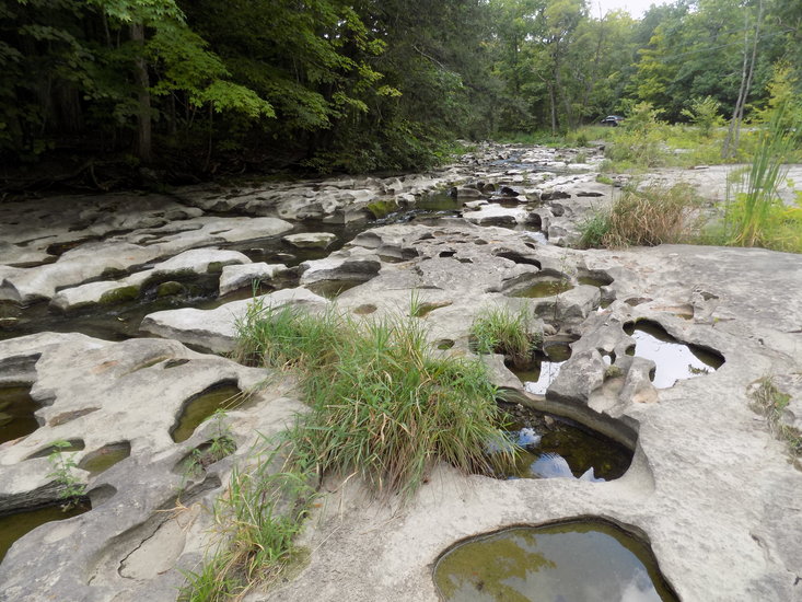
The Onesquethaw Creek south of Clarksville emerges from the woods and flows for a time along Lower Flat Rock Road, exposing its strange topographic features to easy viewing.
— Photo by Mike Nardacci
Erosion and chemical solution have formed a series of descending terraces, some partially blocked by vegetation. Water flows over, through, and around these terraces to create a confusing maze.
— Photo by Mike Nardacci
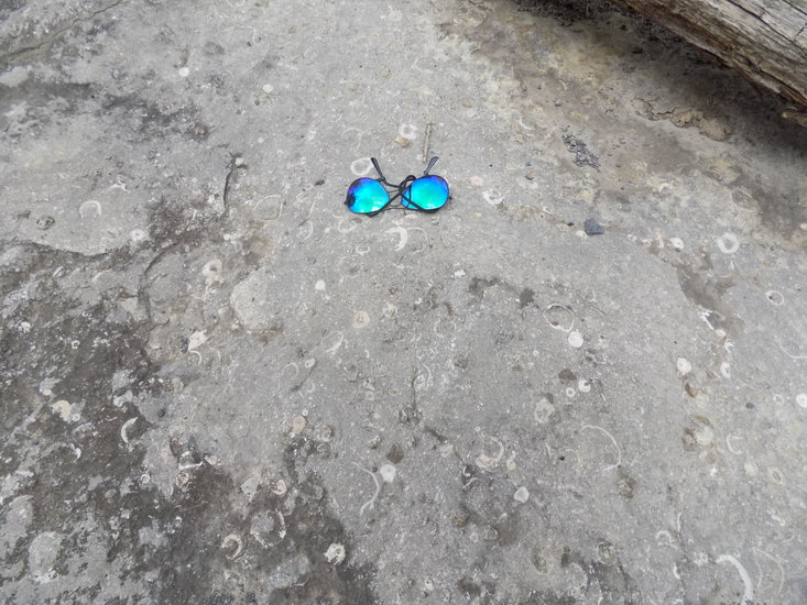
Becraft Limestone contains massive quantities of fossilized fragments of ancient shellfish called brachiopods, visible as crescents or rings. A pair of sunglasses is included for scale.

— Photo by Mike Nardacci
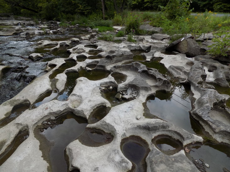
Close-up of a section of the streambed showing the confusing maze and some temporarily isolated potholes providing mini-environments for minnows, pollywogs, and water bugs.
— Photo by Mike Nardacci
The Onesquethaw continues its southward flow through channels and potholes in the Becraft Limestone, eventually to join up with the Coeymans Creek before entering the Hudson River.
The stream called “Onesquethaw” undergoes extensive changes as it flows from its placid source in our portion of the Appalachian Plateau known locally as “the Helderbergs.” It incises its way through several rock layers — or “strata” — from the Devonian Period, which are between 360 and 400 million years old.
It has formed canyons, flows lazily over stretches of level terrain, and gurgles over gentle rapids and through potholes. Eventually it joins with Coeymans Creek before discharging into the Hudson River where its waters mix with those of thousands of other tributaries on the river’s course toward the Atlantic Ocean.
Some of the Onesquethaw’s most rugged and picturesque segments are off limits to most hikers as it flows through private lands; however, a stretch that parallels Lower Flat Rock Road off the section of Route 443 known as the Delaware Turnpike is easily accessible by car or bike and provides a quiet place to reflect on our area’s almost unimaginably long geologic history and the thoughts that changing seasons bring.
Privately-owned Helderberg Lake lies just north of Route 443 where it briefly runs congruent with Route 85. The lake was enlarged by an artificial dam in the 1930s and at its southern end its overflow becomes the Onesquethaw Creek as it cascades down a series of terraces and has carved out a steep gorge that descends for a mile or so as it plunges out of the steep hills of the town of Berne.
Almost entirely on parcels of private property, the gorge is formed from the thin-bedded Hamilton rock layers, strata composed of dark sandstones and shales. About 220 million years ago, a vast landmass that was to become Europe was beginning collision with proto-North America in one of the great movements known as plate tectonics.
The collision was closing the body of water that had divided the two landmasses and was pushing up a towering range of mountains in what is today eastern New England. Rain and snowmelt washed millions of tons of sediments from the slopes of these ancient mountains, filling in the waterway between the land masses and forming a series of interlocking deposits termed by geologists “the Catskill Delta.”
The deposits eventually turned to rock and are visible in western Albany County and throughout the extensive eroded plateau known as the Catskill Mountains.
This material alternates between being moderately resistant to stream erosion and poorly resistant, and thus the gorge below Helderberg Lake frequently exhibits a profile similar to that seen in many canyons in the West such as the Grand Canyon: a series of alternating steep and gradual slopes covered with piles of enormous quantities of eroded fragments called “talus.”
Near the area where Wolf Hill Road, Route 85, and Route 443 intersect, the Onesquethaw has cut down through the sandstone and shale layers to the Onondaga Limestone, the highest stratum of limestone in Albany County. The Onondaga is a hard, clean gray stone, indicative of its formation during the Devonian Period in clear, shallow, warm waters.
It is rich with fossils of many kinds of corals and in places features nodules and beds of chert, a dense rock commonly known as flint composed of silica. A number of extensive Albany County caves have formed in this layer.
For the next couple of miles, the stream runs parallel to Route 443 over nearly flat terrain with a surface bedrock of the Onondaga which in this stretch is highly fractured. In dry times of the year, the stream may flow entirely under the exposed streambed leaving it bleached and dry. In periods of heavy storms and snowmelt, the Onesquethaw boils to the surface and, gathering temporary energy from the flood pulse, may create whirlpools and rapids as it flows south toward Clarksville.
But approaching the hamlet, the stream’s path is temporarily diverted east by imposing Bennett Hill, a glacially-sculpted “rock drumlin” composed of the Hamilton strata. Eroded by the mile-high glacier that passed over it thousands of years ago, the step-like terraces of Bennett Hill are visible for many miles.
The Onesquethaw again becomes somewhat energized as it cuts through the limestone at the base of Bennett Hill and flows down through another impressive canyon. Here the stream encounters an extensive series of faults whose “slickensides” — tell-tale parallel grooves carved into the bedrock during an earthquake — are visible in sections of the canyon walls and the streambed, and in places the strata are bent and contorted by the movement of the ancient fault.
Within the canyon are small caves and springs, plunge pools, enormous potholes, giant boulders and slabs detached from the bedrock, and thick deposits of sediments composed of many rock types, some carried down from the Helderbergs, others left behind long ago by the retreating glaciers.
But in this stretch, the Onesquethaw is described as an “underfit” stream, meaning that with its average velocity — which for most of the year in these modern times is not much more than a trickle — it is incapable of eroding great chunks of the canyon’s hard bedrock or transporting and polishing large boulders. Much of this erosion occurred at the end of the glacial period when the Onesquethaw may have carried hundreds of times its present-day volume due to the melting of the glaciers.
As the Onesquethaw approaches the eastern boundary of the village, it cuts down into the crumbly Esopus Shale and for a stretch of several hundred feet it has exposed the marvelous fossils characteristic of the Esopus known commonly as “rooster tails.” These fossils represent a vast colony of tube worms whose feeding tunnels radiate out from a single point.
They indicate an ancient environment of relatively deep, calm water in which the delicate worms could have remained anchored to a single point on the sea bottom for a lifetime and burrowed through the murky organics-laden mud absorbing nutrients.
Just beyond the rustic stone bridge over the Onesquethaw on Tarrytown Road there is a pull-off on the left side of the road where a short path leads to the stream’s edge and offers a dramatic view of strata contorted by the movement of an ancient fault.
Beyond this point, the Onesquethaw is not visible from any public road and flows through private land. It continues to cut downward through the Esopus Shale and cascades over an impressive waterfall into a plunge pool.
It finally incises its way through the entire exposure of the Esopus and comes into contact with an even older Devonian layer known as the Becraft Limestone. But it is not until the stream bends and enters the wide, shallow valley through which passes Lower Flat Rock that it again becomes easily accessible and enters one of its most evocative sections.
Here for a thousand feet or so paralleling the road the Onesquethaw flows due south and is bordered on both sides by a forest of hemlocks and pines, floored by ferns, mosses, and other vegetation that flourishes in humid, shady environments. The stream itself broadens out and descends a series of low terraces producing miniature rapids as it continues through a bewildering maze of gurgling and babbling channels, potholes, and plunge pools.
The Becraft limestone layer has a thickness of only about 20 feet in this part of the county, but along Lower Flat Rock Road the rock has been smoothed off by the passage of the ancient glaciers in a broad plain known to geologists as a “bench.” Although much of the bedrock is covered here by a thin layer of soil and the forest it supports, the Onesquethaw’s path reveals the Becraft with its fascinating collection of fossils and erosional features.
The Becraft is a very hard rock and, because its surface was subjected first to abrasion by the glaciers and subsequently polished naturally over centuries by tiny water-borne sediments acting like fine sandpaper, exposures show the clean, gray limestone is flecked with thousands of closely-packed fossils. Mainly these are the shells of sea creatures known as brachiopods and they stand out as shiny white circles or crescents.
The Becraft resembles a rock type called “coquina,” which consists of great masses of fragments of sea shells naturally cemented together by calcium carbonate and often found near reefs and on the coast of Florida and islands in the Caribbean Sea. That most of the shells have been shattered indicates that the rock formed millions of years ago in relatively shallow-water environments in which the shells were subjected to violent agitation and deposition by waves in Devonian seas.
In addition, the Becraft in the streambed shows many fractures and joints — cracks caused by repeated freezing and thawing over centuries as well as expansion of the bedrock as upper layers are removed by erosion.
Because the limestone and its fossils are made of calcium carbonate, the rock is subject to chemical weathering by mild natural solvents such as carbonic acid, formed when water absorbs carbon dioxide as it falls through the atmosphere or flows over rotting duff on the forest floor.
As a result, the mildly acidic Onesquethaw waters have worked their way through every crack and crevice in the streambed, dissolving the maze of channels and potholes visible along Lower Flat Rock Road. Small channels encounter larger ones, fractures lead into potholes and plunge pools, and the tiny distributaries enter a confusing pattern of flow, sometimes briefly backwards or sideways or in miniature whirlpools, but eventually forward toward the Hudson under the pull of gravity.
Tiny dams formed by the presence of water-loving plants or water-borne debris create miniature pools of slow-moving or still water in which minnows and pollywogs and water bugs find refuge, feeding on tiny prey or bits of organic matter carried by the stream.
And of course, the patterns of flow and the sounds they produce change with the seasons and the weather. Snowmelt and seasonal rainstorms raise the volume of the stream, causing the channels to overflow and create earnest-sounding if temporary rapids.
In dry times — especially late summer and fall — low flow in the Onesquethaw reduces the sounds of the stream to whispers. In winter, thick layers of ice form on the bedrock beneath the overhanging boughs of hemlock, creating weirdly-sculpted shapes in the streambed as well as yet more channels and dams, and water may burst from them like the icy rivers that emerge from the base of glaciers.
At such times, the stream appears black and lifeless and the sounds of fracturing and shifting ice may shatter the quiet of the valley. But with spring will come again the agreeable babbling of the brook and the cries of peepers.
A professor of mine once told our class that to be an effective geologist, one must have a good imagination — and this portion of Lower Flat Rock Road is an excellent stimulant to the mind.
Standing on its banks, one can imagine the crash of ancient seas transporting and depositing sediments and sea shells, the growth and grinding of glaciers during the Great Ice Age, and the relentless shaping and reshaping of the landscape and the labyrinths of the streambed as the Onesquethaw continues its unrelenting search for the sea.