McFails Cave: A dark and winding road, beckoning the curious to explore
— Photo by Mike Nardacci
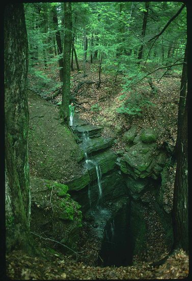
A gaping sinkhole in the McFails Cave Preserve swallows a stream that flows through McFails Cave and resurges over two miles away.
Most New York State caves are closed to visitors from Oct. 1 to May 1. For information about McFails Cave and other area caves, visit www.northeatserncaveconservancy.org.
Karst lands such as those in Albany and Schoharie counties in New York State and elsewhere on our planet have long been described as “hollowed ground.” When the surface bedrock is limestone — and less commonly marble, dolomite, or gypsum — rainwater or surface water that has become mildly acidic due to the absorption of carbon dioxide will infiltrate the bedrock under the influence of gravity; it will then dissolve the rock away, creating underground streams and rivers along with extensive cave systems.
In many regions, thick layers of limestone may be underlain by a type of rock such as shale or sandstone called an aquiclude that will not readily dissolve in acidic water, producing what geologists call base level; the water can then no longer dissolve downward but must find a way out of the rock and emerge as a spring, perhaps in a cliff such as those at Thacher Park or an artesian spring in which water under pressure flows upward against gravity.
Cave passages frequently develop along tectonic faults or angular cracks in the bedrock called joints, and so it is possible for several caverns with a common base level to join and form one extensive cave system.
In central Kentucky, for example, a number of lengthy individual caves on a plateau above the Green River have been found to connect to Mammoth Cave, producing a system now known to be over 400 miles in length. And similar geologic conditions in the plateau for thousands of surrounding acres hint that the cave’s passages may someday be found to extend for additional hundreds of miles.
The plateau stretching for miles above the city of Cobleskill can be seen as a somewhat smaller-scale version of the Mammoth Cave karst area: smaller-scale because its fossil-bearing Devonian-age Manlius and Coeymans limestone layers are much thinner than the 400-foot-thick limestone strata of central Kentucky and this fact limits the depth and number of the levels on which local caves can develop.
The forests and fields of the Cobleskill Plateau abound in known cave systems of various lengths, and yawning sinkholes — some 70 or more feet in depth — swallow rushing streams in warm months and belch clouds of icy condensation during times of severe cold, creating landscapes out of “The Lord of the Rings.”
Some of the plateau’s cave systems are known or suspected to connect with one another but dozens of sinkholes that are occluded by glacial boulders and soil allow only water to infiltrate and travel underground to previously known cave systems or still unknown destinations, effectively excluding human explorers.
Discovering McFails
One cave in particular, called McFails, the extent of which was unknown until the 1960s, has long excited both sport cavers and geologists. Its historic 110-foot vertical entrance lies in a stretch of mossy, shadowy acres of hardwoods and hemlocks filled with fissures, gaping sinkholes, and disappearing streams, all of which are known to feed into McFails.
Its name derives from the report that in the 1870s on a particularly hot and humid July day, a professor from a local academy by the name of T.C. McFail had descended on a rope ladder to the interior of the cave, a tight, wet, muddy fissure.
Whether he went any farther is unknown, but on his way back up the ladder — which he was climbing without a safety line — he passed suddenly from the 46-degree temperature of the cave into the sultry July heat and fainted, falling from the ladder and striking his head on a boulder. Despite his companions’ rescue efforts, he died, leaving his name as an ironic memory of his ill-fated exploration.
For nearly a 100 years, explorers entering the cave with proper technical equipment found only a few hundred feet of gloomy stream passageway, becoming too tight for human passage upstream and vanishing into a floor-to-ceiling pool downstream.
But in 1961 during a time of low precipitation, explorers from Cornell University found several inches of air above the pool and, though they had to get thoroughly soaked, they managed to push through the pool to find themselves in a high canyon with a rushing stream sometimes waist-deep that stretched for two miles and was filled with pristine formations.
And, as the canyon expanded into a series of chambers that rivalled in size those in nearby commercial Howe Caverns, another large passage — this one with a tubular cross-section and bearing another stream — entered from the northwest.
It was initially thought to extend for over a mile and terminate in a pile of huge breakdown boulders and slabs but explorers have pushed through it to find more of the main passage and side chambers that are still not fully explored.
Downstream the rushing creek passes through several “sumps” in which the water rises to the ceiling. These have been penetrated by divers to a point at which the passage becomes blocked to further human exploration.
And more recently, intrepid explorers have found an upper level to the canyon passage filled with stalactites, stalagmites, and exceedingly delicate, glittering formations called helictites, all of which form through the evaporation of mineral-saturated water. Most visitors are encouraged to avoid the area to avoid damaging them.
Owned today by the National Speleological Society, the cave and its surrounding karst features are managed by the Northeastern Cave Conservancy, and draw scientists and adventurers from all over the world.
Connections
Years ago, the historic entrance to McFails became unstable and collapsed. Today, entrance to the cave is made through either of two vertical drops requiring ropework.
One has the Tolkien-ish name of “Ackshack” and also requires an exhausting 100-foot crawl leading to the main cave. The other is a dizzying descent of a silo-like pit that frequently takes explorers through a gushing waterfall.
In any case, the preserve rules require visitors to wear wetsuits to avoid hypothermia on trips, which frequently last upward of 12 hours.
Hydrogeologists use a technique called “dye tracing” when water is flowing through a cave system with fissures that are too tight for human passage. A harmless dye is injected into the water and watch is kept on springs and streams in nearby caves to see where it emerges.
Years ago, it was determined that in times of normal flow the stream flowing through McFails Cave eventually finds its way to Doc Shauls Spring — an enormous artesian spring located in a crater-like depression more than two miles from the main entrance to McFails. From there it becomes tributary to the Cobleskill Creek.
However — in times of heavy snowmelt or excessive precipitation such as a tropical storm, the main passage of McFails becomes inefficient to carry all of the water rushing through the cave and the excess overflows into Howe Caverns, also more than two miles away from its insurgence points.
What makes the geologic situation even more interesting is the fact that a number of caves in the hills around Howe Caverns are connected to it — or were in the past. The remnant downstream section of Howe Caverns that was largely destroyed by quarrying operations is joined to Barytes Cave, which still exists.
Barytes in turn receives water from another undeveloped (or “wild”) cave called Benson’s, which is connected hydrologically to commercial Secret Caverns. These caves are all formed in the Manlius and Coeymans limestone layers and have a common base level.
Hence, estimates are that, if all of the known or suspected fragments could be joined, Schoharie County could boast of a cave system around 26 miles long. But then the Cobleskill Plateau is pockmarked with many karst features that could eventually be found to lead to new, separate cave systems or to be part of the vast complex.
In the shadow of looming Barrack Zourie Hill, one other such independent cave is known; it has been explored for a distance of two miles and has a stream that is also a tributary to the Cobleskill Creek.
The Cobleskill Plateau has long been known for its lush hardwood forests — enticing in all seasons, spectacular in the fall — its rocky cliffs and stony streams, its diverse animal and plant life, its fertile fields and orchards, and its long and colorful history from the days of its indigenous inhabitants through its Colonial period, down to the present.
But its fame as a geologic wonder has for a long time been much less appreciated. Under the plateau’s ancient, rolling hills, chemistry and gravity have been at work for millions of years, creating a vast and still not completely known network of long, meandering channels through the darkness that beckon the curious to explore.