Senior-living sites to be centered near Western and Carman?
The Enterprise — Michael Koff
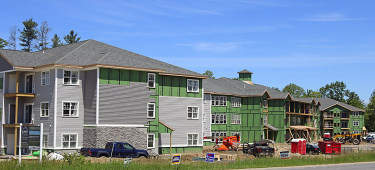
Construction continues on Summit Senior Living, an independent-living apartment complex that will have 92 units for people aged 55 and older, on Route 155 at Mill Hill Court.
GUILDERLAND — The town is considering a change to the zoning code that would define where independent-living facilities for senior citizens — usually 55 and above — could be located in the town.
The code would be changed so that any of the three types of facilities for seniors — nursing home, assisted living, and independent living — would be allowed, with a special-use permit, in single-family residential zoning districts as long as it meets new criteria for which roads the facilities can be built on.
The code currently allows all three types of facilities on all town roads. A proposed change calls for these facilities to be restricted to locations that are within 500 feet of a state road or have direct access onto a county road. The location would also need to have public water and sewer.
At a public hearing scheduled for June 18, one of the items that the town board will consider is on exactly what roads these facilities should be allowed. Instead of allowing them within 500 feet of all eligible state roads, it may amend its proposal to limit them to lots that are within 500 feet of Western Avenue and Carman Road, for example. It may extend the number of feet from 500 to 1,000.
The issue was discussed at a public hearing at the May 21 town board meeting. The hearing was eventually continued to the next board meeting, on June 18.
The board voted on part of this issue May 21: It decided, 4 to 0, with one member absent, that there must be a 100-foot setback between a senior independent-living facility and an adjoining residential lot.
Town Planner Kenneth Kovalchik used an overhead projector to show a Geographic Information Systems, or GIS, map created by Senior Planner Zeynep Tas of Guilderland’s planning department that clarified where existing sewer and water systems are located, and their proximity to county and state roads and to sidewalks. The map showed properties within 500 feet of a state road using one color, and properties located within 1,000 feet of state roads with another.
Kovalchik told the board, “The goal is to encourage [senior independent-living facilities] within proximity to daily needs, whether public transit, shopping needs, going to see a doctor — typically, all of those uses are going to be located on a state or a county road. So what this tells me,” he said, “is we should try to concentrate these uses where the existing water and sewer infrastructure is, where the existing mass transit is, and where the existing daily needs are.”
Instead of placing the facilities on more rural roads such as Meadowdale, Depot, or School roads — and potentially increasing development on those relatively rural roads — Kovalchik said it seemed better from a planning perspective to center development “along Western Avenue, along Route 155 potentially, and then Carman Road.”
The town’s supervisor, Peter Barber, said there is not much by way of daily needs or sidewalks on Route 155 south of the middle school, and Kovalchik agreed. The two discussed the idea that perhaps Route 155 should be reserved for direct access, and not 500 feet from a state road. Kovalchik told The Enterprise that the town would decide what to propose for Route 155: direct access or 500 feet.
“As a planner,” Kovalchik told the town board, “I would want to encourage density along the Route 20 corridor, because you’ve got access to mass transit, you’ve got access to your daily needs, so potentially, if you have this use close enough to those needs, somebody could walk to get a cup of coffee, walk to buy their groceries, walk to get on a bus —”
Kovalchik told The Enterprise this week, “You want them to be closer to where daily needs are, because you could potentially reduce your daily trips and your impact on the town roads.”
He told The Enterprise what would likely be proposed was to center the facilities within 1,000 feet of Route 20 or within 500 feet of Route 155 or to properties that have direct access onto a county road. Kovalchik said there had not yet been much discussion about how the town proposed to handle roads near Carman Road.
State roads in Guilderland include: Routes 397 (Dunnsville Road), 156 (Altamont-Voorheesville Road), 158 (Guilderland Avenue), 155 (State Farm Road), 20 (Western Avenue), and 146 (Carman Road and Main Street in Altamont). According to spokesman Bryan Viggiani of the state’s Department of Transportation, part of the Northway and part of Washington Avenue Extension are also state roads in Guilderland.
The town’s county roads include: Johnston, Fuller, Schoolhouse, Meadowdale, Depot, and School roads. County roads also include these roads, or at least parts of them, according to county spokeswoman Mary Rozak: 201 (New Main Street), 155 (New Karner Road), and 253 (Bozenkill Road).
The pace of growth
The Enterprise asked Kovalchik if centering these facilities near Western Avenue worked against the purpose of the Transit Oriented District in Westmere, a new zoning district created last year in the area around Crossgates Mall to try to divert traffic away from Western Avenue and onto the ring road.
“We’re trying to center that development on Western Avenue,” Kovalchik said, “because right now you can do a senior use on any town road in Guilderland. So, from a planning perspective, I wouldn’t want to see those types of higher-density uses out on a more rural road.”
Concentrating development where infrastructure and mass transit already exist can prevent sprawl into rural areas, he said.
The Enterprise also asked Kovalchik about urbanization and whether there would be a point when town officials would say that there had been enough development, or whether it would be OK for Guilderland to eventually turn from a town to a city, into another Colonie.
Kovalchik said the two populations are not comparable, with Guilderland’s at about 35,000 and Colonie’s at about 82,000; he was using figures from the 2010 federal census. Guilderland is not going to experience the “historical, phenomenal” growth that would turn it into another Colonie during the next 10 or 15 years, he said. Maybe in 50 years, he said.
But the town is taking steps to address that, he said, such as the conservation easement exemption that is still moving forward. That separate proposed local law would give land owners the option of receiving exemptions from property taxes for retaining their land as open space rather than selling it to, for instance, a developer. The percentage of the exemption would increase with the length of time set for the land to remain open space.
“What’s really going to dictate population growth, Kovalchik said, “will be the existing capacity and the future capacity of our water and wastewater department. That’s something they are working with Delaware Engineering on now, in terms of our existing pump station. That’s really going to dictate the pace of growth moving forward.”