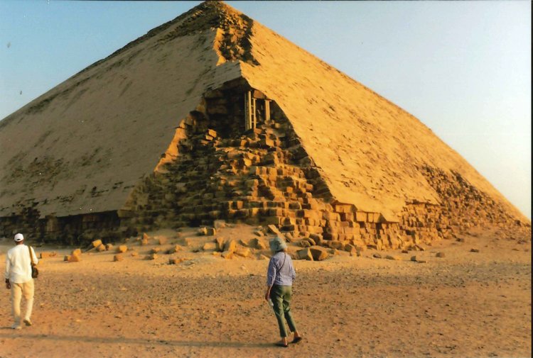
— Photo from Mike Nardacci
“The Bent Pyramid” is 600 feet on a side and towers 330 feet above the Sahara.
The pyramids on the Giza plateau west of Cairo are almost certainly the prime attraction for visitors to Egypt and they may draw thousands a day during the height of tourist season.
Relics of Egypt’s Old Kingdom rising starkly out of the desert, they overwhelm the visitor with their gigantic profiles. Though the 4,600-year-old Great Pyramid of Pharaoh Khufu is the most famous and towers nearly 450 feet, its neighbors belonging respectively to Pharaohs Khafre and Menkaure are stunning in their own ways. That of Khufu’s son Khafre is only a few feet lower than the Great Pyramid and, while Menkaure’s pyramid is only half the size of the other two, it projects its own grandeur.
These structures are massive, built of millions of limestone blocks weighing many tons and inspiring numerous theories — some remarkably daft — as to how they were constructed.
Perhaps the most outlandish is that they were built under the direction of alien beings who, having solved the challenge of faster-than-light travel, crossed many vast stretches of space for the purpose of showing less technically accomplished people how to pile up rocks. Might they not more profitably have taught them about electricity, computers, and advanced medicine?
Then there are those who insist that the three Giza pyramids are for some esoteric purpose lined up in a row like the stars in the belt of the constellation Orion — blithely ignoring the fact that any three objects in a row are arranged like the stars in the belt of Orion.
Nonetheless, there remain many questions as to how the ancient Egyptians raised the blocks in the pyramids to such great heights; how they managed to organize, feed, and house the required workforce; and what the impulse was to raise such monuments so that their kings might enjoy eternal life with their gods.
The fact remains, however, that there are many, many more pyramids on the west bank of the Nile River — they may number as many as 100 — some older than the Giza pyramids, some nearly as large, some eroded to heaps of rubble resembling natural rocky outcrops in the desert. They vividly show the evolution, the flourishing, and the final dissolution of the technology that raised them.
And contrary to popular depictions — Cecil B. DeMille notwithstanding — these structures were not built by slave labor. The graves of the men who raised them have been found and their remains are those of workers who not only enjoyed healthy diets but were given the best medical treatment available for injuries.
They frequently left behind graffiti on the blocks with which they were building indicating that they worked in teams that were in competition with one another, perhaps vying for extra portions of beer or time off.
But for all of their grandeur, it must be admitted that seeing the Giza pyramids at the height of tourist season as I did recently when they are surrounded by enormous noisy crowds posing for photos, bargaining with souvenir sellers or camel drivers for rides, or lining up in chattering groups for the chance to enter the pyramids’ eerie interiors can induce a negative reaction. Tourist brochures that show the pyramids seeming to be in isolation in the desert with nary a soul in sight are wildly misleading.
Pharaoh Sneferu’s pyramids
But a couple of dozen miles south of Giza on a lonely stretch of the great limestone plateau called Dashur rise the pyramids of Pharaoh Sneferu — well, two of them anyway — and they illustrate a remarkable chapter in the history of pyramid construction.
Sneferu was the father of Khufu and his building activities not only seem to have inspired his son to outdo him, they created a construction force that accomplished astonishing —sometimes bewildering — things and made possible the wonders of the gigantic pyramids of Giza.
But the story of Sneferu’s pyramids begins about 20 miles from Dashur on a site with a spectacular view of the Nile River where Sneferu ordered the construction of what is now known as the Pyramid of Meydum (or Meidum). Googling the name and clicking “images” reveals a structure that looks like a tower rising above the desert — all that remains of Pharaoh Sneferu’s initial bid for immortality.
And that was precisely the function of pyramids — they are what archaeologists term “resurrection machines”: Pyramids were intended to carry the deceased pharaoh to the realm of the Sun-god Ra. For generations before Sneferu, pharaohs built what are called today “step pyramids,” looking like huge staircases reaching toward the sky.
But perhaps inspired by shafts of sunlight breaking through clouds and forming wedge shapes on the horizon, Sneferu commanded his architects and engineers to try something new.
After what must have involved years of planning and construction, something went wildly wrong. Whether the ground beneath the pyramid was too soft to bear its weight or there was some major engineering error as the structure grew in mass, a catastrophic collapse occurred and much of the pyramid was reduced to a pile of rubble on which its interior structure sits today.
Interestingly, the intended burial chamber and the passages leading to it survived the collapse. But Pharaoh Sneferu was not about to start his journey to the afterlife in this monumental failure so he ordered his engineers and work teams to start a new pyramid, this one in the site called Dashur.
No one knows how much time and treasure was lost in the building of the Meidum pyramid — the ancient Egyptians did not keep records of such endeavors — but Sneferu’s subjects dutifully regrouped and went to work. One does not question the will of a god-king.
The result of their efforts stands today above the bleak sands of Dashur — the strange construction known as “the Bent Pyramid”-- (Figure 1) 600 feet on a side and towering 330 feet above the Sahara, the enormous structure is visible from many miles away.
But its odd shape demonstrates that Sneferu’s engineers had not yet fully learned from their failure at Meidum. As the pyramid grew in elevation, cracks began to appear in its base threatening collapse.
The slope of the pyramid was evidently too steep and had exceeded the angle of repose, meaning that the whole thing could collapse as had the pyramid of Meidum. To solve the problem, they changed the angle of the sides, thereby reducing its final weight and resulting in the “bent” profile the pyramid exhibits today, though the separation of some of the lower sections of the structure show the effects of the steep angle.
The interior of the pyramid was also completed — a complex series of tunnels and rooms leading to an impressive burial chamber with a corbelled ceiling. The fact that these are intact after over 4,600 years shows that Sneferu could indeed have agreed to be interred there.
But incredibly the pharaoh appears to have said something like, “Very nice but not what I ordered up. Let’s try again.”
It is at this point that two relevant facts should be mentioned. The first is that there is a small step pyramid on a site called Seila near Egypt’s fertile Fayum area, which also apparently was built at Sneferu’s command though its interior was evidently never intended for a burial.
The other fact is that, for generations after his reign, the pharaoh was referred to as “Good King Sneferu” and had the reputation of kindness and generosity toward his subjects. What these folks thought about all that labor and national treasure going into the building of Pyramid Number Four is unrecorded.
Known today as “the Red Pyramid,” the giant structure rises about a mile to the north of the Bent Pyramid and it is a masterpiece. Third in size to the Giza pyramids of Khufu and Khafre, it gets its name from the presence of oxidized iron in the limestone blocks from which it was constructed, a coloring that time has intensified.
Its somewhat flattened appearance demonstrates that Sneferu’s engineers had learned from their past errors and gave the pyramid a more stable profile, enduring through the millennia without obvious signs of erosion. Neither Sneferu’s son Khufu nor any subsequent pharaohs in Egypt’s Old Kingdom attempted a pyramid with sides as steep as those of the Bent Pyramid.
Today these monuments induce wonder as they stand in splendid isolation above the desert sands. They are seldom visited. The day my companions and I went to Dashur, there were just three other people at the Bent Pyramid. At the Red Pyramid, there were none.
Yet here rise two of the master works from Egypt’s past proclaiming the ingenuity of their builders and perhaps the ego of their pharaoh. Lacking the sometimes carnival atmosphere that accompanies the Giza pyramids, they silently evoke the mystery and stimulate the contemplation for which they surely were intended.
— Photo by Mike Nardacci
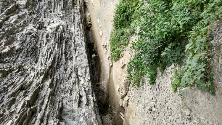
The shelter known as Paint Mine Cave lies at the boundary between sedimentary rock from the Silurian Period and the Devonian Period Manlius limestone.
The recent dedication in Thacher State Park of a historical marker honoring Winifred Goldring, the late State paleontologist, has called attention to her remarkable writings. Though they were published over 90 years ago and have been long out of print, her “Geology of the Berne Quadrangle” and the shorter “Geology of John Boyd Thacher State Park” adapted from it are available in many libraries and occasionally turn up on Amazon or other websites featuring hard-to-find books.
Winifred Goldring lived most of her life in Slingerlands. As a child and as a young woman, she spent much of her time hiking in the Helderberg region and became fascinated with the rock layers and fossils. The Helderbergs and especially the great escarpment are considered classic sites for the study of Devonian-age fossils and have long attracted scientists from all over the world.
Though it has been reported that when she first entered college she intended to study languages, her major required some science electives and the course of her life was set. In 1914, she began work with the New York State Museum. She was named State Paleontologist in 1939, the first woman in the United States to be appointed to such a position.
Over the years, she published numerous articles in scientific journals dealing with fossils. Though many of these are technical and of interest primarily to specialists, her 1935 State Museum Bulletin “Geology of the Berne Quadrangle” — which may well be considered her magnum opus — is an elegantly written work bringing the wonders of Helderberg geology to the general reader.
Scientific writing can often seem very dry to nonspecialists but writers such as John McPhee, Neil deGrasse Tyson, and our Hudson Valley author Robert Titus have a talent for not only making difficult concepts accessible to general readers but conveying the awe that scientific phenomena can inspire.
When Winifred Goldring set out to write about the geology of the Helderberg area, she was faced with the challenge of explaining the changing environments that led to the formation of the rock layers — “strata” — that make up the Helderberg plateau. This meant describing the mineral content and the fossils within those strata to illustrate ancient worlds now irretrievably lost in the fog of time.
Goldring begins her work with a discussion of the origins of the plateau, writing in a time when the concept of plate tectonics — so crucial to the understanding of the history of Earth — was unknown. In addition, radiometric dating of rocks to determine their absolute age did not exist.
Thus, although the relative age of rock layers and fossils compared to one another allowed scientists to assign names such as “Devonian” and “Silurian” to geologic periods and to identify specific fossils as being peculiar to certain times, the absolute age of the fossils and the strata that contained them could not be determined.
In addition, the processes that caused the rise and fall of mountain ranges and plateaus and changing sea levels — now explained by the movements of Earth’s tectonic plates — were attributed to phenomena that seem quaint today. Nonetheless, in Goldring’s prose ancient environments and the creatures that dwelt in them are powerfully evoked.
Before her discussion of the strata, Goldring includes sections of her work on the vegetation of the area and the history of human settlements. She explains how the mineral content and physical characteristics of the rock layers determine the type of forest that each supports.
She devotes 20 pages to the history of the towns in the Berne Quadrangle and how they were influenced by its geology and geography as they developed. She also includes a short section on John Boyd Thacher State Park, which was later adapted and expanded into a separate monograph.
Diverse marine environments
The strata of the Berne Quadrangle are sedimentary, primarily shale, sandstone, and limestone and each tells a different geologic story. Underlying the villages of Altamont and New Salem are the Schenectady beds and the Indian Ladder beds, sandstones and shales dating to the Ordovician Period, now known to be some 450 million years ago.
The sediments that compose them and the fossils contained therein — especially large quantities of fossil seaweeds — indicate they formed in the near-shore environment of an ancient ocean. Shale tends to form from petrified mud and the presence of muddy or sandy layers indicates transport by rivers and streams. These sediments also imply the presence of nearby highlands — perhaps mountains — from whose slopes the sediments have been eroded.
Above them are two thin transitional beds, strongly suggestive of a continued ancient muddy environment, one of which — called the Brayman Shale — contains crystals of iron pyrites, commonly known as fool’s gold. In a number of places in the Helderberg Escarpment, these layers have weathered back beneath the strata above them producing shallow rock shelters sometimes erroneously labeled “caves” as in Paint Mine Cave on the Indian Ladder Trail.
Towering over the trail are two massive limestone layers, the Manlius and the Coeymans, both of which formed in the Devonian Period about 360 million years ago.
Named for the towns in New York state where they were first studied, these pure limestone units formed in an ocean environment in a time when there were no nearby mountains or streams to flood them with muddy sediments.
Resembling a stack of books, the thin layers of the Manlius are filled with tiny fossils called tentaculites. Looking like tiny carrots, these miniscule creatures were pteropods — cone-shaped shellfish — and a small slab of the Manlius limestone will often contain hundreds. Sometimes they are lined up parallel to one another, indicating that they died in shallow water affected by tidal currents.
Higher up in the Manlius are fossils of stromatapora, coral-like creatures that formed extensive reefs, which are preserved in the rock in easily observable swirling patterns.
The massive Coeymans limestone forms much of the upper part of the escarpment. It is filled with fossils such as brachiopods, sea lilies, corals, and trilobites, which suggest an environment similar to that of the Bahamas: warm, clear, rather shallow water. Being pure limestone, the Manlius and Coeymans readily dissolve to form caves, and extensive caverns in Knox, Gallupville, and Schoharie have resulted.
The slopes above the Coeymans limestone are in many places heavily forested and the underlying strata are not easily seen. However, their thick collections of fossils tell of rising and falling shorelines and strata originating on high-energy shorelines in which limestone has formed from massive layers of crushed shells and beach environments consisting of sand mixed with large shell fragments.
Higher up is a second prominent escarpment composed of the massive Onondaga limestone; its fossils tell of ancient reefs with a rich collection of creatures such as varieties of coral as well as sea lilies and trilobites. Like the Manlius and Coeymans, the Onondaga is a very pure limestone and many extensive caves have formed in it, notably in the Clarksville area.
Above the Onondaga are massive strata of shale and sandstone extending down through the Catskills and telling of the rise of a huge mountain range to the northeast during Devonian time from whose jagged slopes vast quantities of sand and silt were eroded into an extensive series of alluvial fans known today to geologists as the Catskill Delta. In its upper strata are the fossils of tall fern trees, among Earth’s earliest land plants.
A gift for the future
While Goldring notes with some wonder these diverse marine environments, she does not attempt to explain the cause of changing sea levels that result in these broad differences. For much of the first half of the 20th Century, geologists attributed the rise and fall of sea levels to a phenomenon known as “geosynclines.”
It was believed that there were depressions in the ocean floor into which massive amounts of sediment were being deposited by surface rivers and streams. At some critical point, the Earth’s crust would rebound like a trampoline carrying the strata and their fossils to great heights, forming high hills and mountain ranges.
The theory of plate tectonics in which Earth’s landmasses drift around the surface and interact with each other, colliding to throw up mountain ranges or volcanically producing ocean basins, had actually been proposed in the 1920s but was regarded as fantasy.
At the time of her death, Goldring was undoubtedly aware of “the new geology,” but never had the chance to rewrite “Geology of the Berne Quadrangle” in its light.
Nonetheless, the work stands as a readable, beautifully illustrated description of the strata that make up the Helderberg area and the ancient creatures that lived in the oceans in which they formed.
She describes the streambeds and hills and hollows of the plateau as places where environments that lie so far in the past as to be mind-boggling become accessible to the curious. When intact copies of the book are found, they come with an Earth-toned geological map that is not only a useful scientific tool but exists in its own right as a work of abstract art.
Dated in some aspects as “Geology of the Berne Quadrangle” may be, it remains a monument to the work of a remarkable woman who — like so many others — was enthralled by the history recorded in the rocks of the Helderbergs and chose to share it with those who came after her.
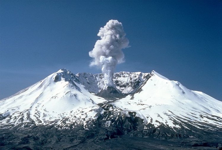
— Photo by Lyn Topinka, United States Geological Survey
After: A plume rises nearly 3,000 feet above the volcano’s rim on May 19, 1982.
Sometimes, when I am about to write a column on one of my experiences, I am faced with a dilemma: Does this belong in the category “Backroads geology” or in “Awe”?
Over the years, I have written on the geology of the Grand Canyon, the Hawaiian lava flows, Egypt’s Valley of the Kings, and Chaco Canyon in New Mexico — all of them with interesting geology but also inducing awe.
The climb of Mt. St. Helens, which I undertook with a friend some years ago, certainly confronted us with some textbook examples of geologic forces but also exposed us to the power of nature to both destroy and create on a massive scale. And though awe can sometimes reduce a person to silence, in this case our first view of the destructive aftermath resulted in an incongruous Anglo-Saxon expletive. But more of that later.
Prior to May 18, 1980, Mount St. Helens was known as America’s Mount Fuji. A steep-sided peak with its summit eternally snow-covered, it loomed above its surrounding landscape as in a Japanese block print: One could imagine it viewed through the branches of a cherry tree in full bloom under a milky blue sky with a diminutive pagoda as a symbol of the smallness of human constructions compared to those of nature.
But the tranquility of such a scene was illusory. Like Mount Fuji and a number of other dangerous peaks in the Cascade Mountains — Rainier, Mount Hood, and Baker among them — Mount St. Helens is a strato-volcano.
It is composed of layer upon layer of debris blasted out of the earth over millennia in a series of violent eruptions. Beneath the snow-capped peaks of the Cascades lies a subduction zone — a gigantic fault line at which one of Earth’s lithospheric plates is diving under another. The resulting friction causes melting of the rock on a massive scale, which then can rise to the surface and explode with terrifying force.
Explosion
And that is precisely what happened on May 18, 1980 after weeks of increasingly strong tremors and bursts of ash coating the mountain’s snowy summit.
Early that morning, the series of earthquakes that had been giving ample warning of magma on the move through a chamber beneath the mountain produced a major temblor that shook the ground for miles around followed by a gigantic landslide on the north slope.
Anyone who has ever shaken a warm bottle of a carbonated beverage and then loosened the cap could predict what happened next. The instant that the magma in the chamber had access to the vastly lower pressure outside, it exploded with almost unbelievable violence — laterally instead of vertically from the summit as might have been expected.
In a scorching explosion called a pyroclastic surge, three cubic kilometers of the mountain disintegrated and blasted northward at hundreds of miles an hour, destroying great stretches of forest, burying half of pristine Spirit Lake, and killing unknown numbers of wildlife; 67 people unfortunate enough to be hiking or camping in the line of the blast also perished.
In an instant, “America’s Mount Fuji” was turned into an ugly crag with a gigantic gaping crater where its gleaming snow-capped summit had been.
Recovery
And then the mountain went back to the slumber in which it had rested for centuries.
Anyone who has seen the photos of the explosion and subsequent devastation would find it hard to believe that the land north of the mountain could recover in many lifetimes. But volcanic soils are loaded with minerals — those that buried Pompeii are some of the most fertile in Italy — and within a very few years the landscape to the north began to turn green as seedlings and grasses took root and shortly herds of elk were seen grazing in the blasted area.
Scientists and hikers alike were stunned by the ability and swiftness of the recovery even amid the wreck of millions of toppled trees. Within a few years, permits were being issued on a limited basis allowing climbers to ascend the southern slope of the mountain, which was relatively unscathed in the catastrophic blast.
Yet even as hikers made their way through the forested lower sections and across the slender glaciers that stretched down from the heights above timberline, within the raw crater a huge steaming dome of solidified lava showed that St. Helens was slowly rebuilding its summit.
My climbing companion and I had spent the night before our climb in the tiny village of Cougar (population 122) some 13 miles southwest of the mountain. The townspeople had made the most of the fact that visitors to the volcano would pass through the village and souvenir shops had popped up selling postcards, paintings and photographs of St. Helens, DVDs of the event, and pottery made with volcanic dust
It undoubtedly was a sobering thought for the population that, had the mountain’s erratic explosion occurred on its south side, the village and its population would have been obliterated.
Ascent
We began our ascent on a cool morning at the trailhead called “Climbers’ Bivouac,” at an elevation of around 5,500 feet — a starting point higher than any mountain peak in New York state, and the relative thinness of the air was apparent as soon as we set out.
During summer months, the number of climbers was limited to 100 to protect the fragile environment and we had secured our permits some weeks before. The trailhead is surrounded by tall Douglas firs that were relatively untouched by the blast, unlike the devastation on the north side of the mountain.
We had slathered our faces and arms with sunscreen as the sun is intense at high altitudes, especially on such a near-cloudless day as this one. The trail led in a series of switchbacks up through the forest and crossed a series of small brooks trickling down from ice higher up on the mountain.
But we soon noticed something ominous: Instead of the dark, loamy soil one would expect in an old forest, a thick gray layer of ash covered the ground between the trees, residue from the blast.
As we approached timberline, the view suddenly became expansive: snow-capped jagged peaks of the Cascade Mountains against a deep blue sky with a few high, wispy clouds.
Now the slopes above us were covered with angular boulders patterned with lichens of many colors and from their shadows the furry little rodents called pikas were whistling warnings of the intruders to their companions.
We had not seen any other climbers but occasionally we could hear voices from above so we knew we were not the first on the mountain that morning. The temperature was dropping with the altitude and the dryness of the air was making us thirsty so we paused to put on parkas and swig some Gatorade.
The trail then took us through some crusty patches of snow and across the diminutive Shoestring Glacier on which numerous small brooks trickled over the ice under the high sun.
The trail became steeper and because of the increasing thinness of the air — we were nearing 10,000 feet — every step became more exerting. Now we were ascending over slippery volcanic dust; the switchbacks became tighter and steeper and soon high above us was the top of Mount St. Helens.
But there was no peak.
Instead we could see a long, flat ridge and a handful of climbers perched on it. The ascent had taken just about three hours and now the sunlight was intense. Near the top, the trail disappeared into rubble and a scattering of herd paths continued upward. And then we arrived at the rim of the crater and the devastation lay starkly before us.
“Holy s***!”
I don’t remember which one of us said it, but a group of climbers a few dozen feet away eating their lunches burst into laughter. We must have looked at them with very puzzled expressions because one of them said, “Everybody who has come up the trail and taken a look says the same thing!”
We were standing on the rim of the crater from which a layered cloak of ice several feet thick plunged downward over a thousand feet. Like a great rocky amphitheater, the crater opened, and in its center the steaming lava dome — now a couple of hundred feet high — showed that the mountain’s subterranean fires were still very active.
To the north, millions of parallel, charred fallen trees showed the result of the pyroclastic surge that had rushed from the explosion at hundreds of miles per hour, burning everything in its path that it did not bury.
In the far distance, once-pristine Spirit Lake was now half its size and thousands of denuded trees floated like abandoned canoes on its surface along with tons of pumice pebbles — volcanic rocks less dense than water.
The scene quickly evoked silent contemplation, broken only a few minutes later when another party reached the rim and stared for a moment before one of the awestruck climbers said, “Holy s***!”
In real time, it could of course be hundreds of years before Mount St. Helens next erupts and by then the great mossy forests that will surround it may be filled with vast herds of elk and mountain goats and the occasional bear roaming the apparently benign landscape.
But in geologic time that is but the wink of an eye and beneath the mountain the magma will still surge and only the occasional coating of ash on the gleaming snowcap of the mountain will indicate that it is about to awaken from its slumber.
There is no way to predict in which direction the volcano may next unleash its destruction. But St. Helens is only one of the volcanic peaks of the Cascades that could erupt.
Mount Rainier, sitting so near the cities of Seattle and Tacoma, is said to be among the most dangerous, covered as it is in glaciers that would melt in an eruption sending great rivers of suffocating mud behind its pyroclastic surge, burying everything in their paths.
One can only wonder at the human propensity to build our cities in places subject to earthquakes and tsunamis and volcanic eruptions and other geologic hazards. And how ironic that they are often locales of awesome beauty.
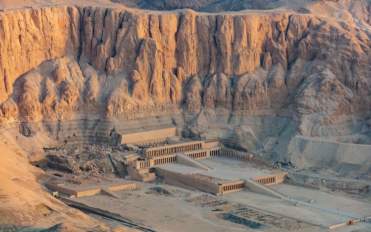
— Photo by Diego Delso, delso.photo, license CC-BY-SA
Known in ancient times as “Djeser Djeseru” — “the holy of holies” — the great temple of Pharaoh Hatshepsut is the work of Senenmut, her architect and consort.
It appears in the desert like a shimmering mirage — appropriately, as temperatures here can rise to 125 degrees Fahrenheit. At the base of the mountains west of the Egyptian city of Luxor in an embayment called Deir el-Bahari sits the temple known in ancient days as Djeser Djeseru — “the holy of holies.”
It was constructed at the command of a royal woman named Hatshepsut under the direction of Senenmut, her architect, and is like no other building in Egypt. With its polished limestone pillars reflecting the blazing sun punctuated by dark spaces that draw the eye inwards to the temple’s dark recesses, its design seems to mirror the cliffs above it with their vertical faults and fractures and the shadowy spaces within them.
Though it is three and a half millennia old, it appears modern. Its design and setting evoke awe and its history contains some of the greatest mysteries that have come down from ancient Egypt.
Near the beginning of Egypt’s Eighteenth Dynasty, around 1500 B.C., the country was ruled by a pharaoh named Thutmose II. The word “pharaoh” comes from the Egyptian word “pero” meaning “great house,” and was applied to the kings much as we use today the expression “the White House” to refer to the president.
Thutmose II was married to the royal woman Hatshepsut who may have been his half-sister. (Such relationships were not uncommon among Egyptian royalty.) By her, he had two daughters but no sons and, when he died at an early age, the next in line was his nephew, Thutmose III, a small child who required a regent.
Usurpation
Hatshepsut was only too eager to fulfill the role and soon their images appeared side by side on monuments with inscriptions describing young Thutmose as pharaoh but stating that Hatshepsut “settled the affairs of Egypt.” In the words of Egyptologist Barbara Mertz, that statement must be one of history’s most tactful descriptions of usurpation.
Ancient Egyptian does not have a word for “queen,” as almost all of the rulers during the country’s 3,000-year history were male. The word sometimes translated as “queen” is the Egyptian expression “king’s great wife,” used to describe the pharaoh’s foremost spouse — pharaohs had many!
But before long Hatshepsut dropped her pretense of being the power behind young Thutmose and on monumental walls and in statuary had herself portrayed in the male garb of pharaohs, even to displaying the false beard they wore in ceremonies; on occasion, carvers even confusedly used the words “he” and “she” referring to her in the same inscription.
But since the language lacked a word for “queen,” she is often awkwardly described as “the (female) pharaoh.” Meanwhile, as young Thutmose grew older, he was being denied the throne that should have been his.
Hatshepsut proved herself a capable ruler, quelling rebellions in far parts of the country’s empire, sending trade expeditions to the exotic land of Punt on the east African coast, and building monuments and obelisks.
But one of the first mysteries that emerge is the question of how she persuaded other Egyptian royalty and the common people of the country to accept her role as pharaoh. One would think that such a stunning intrusion into the usual line of succession would have been earthshaking but from all evidence the years of her usurpation of the throne were peaceful and prosperous with time and resources available to build Djeser Djeseru.
Senenmut
How and when Senenmut came into the picture is another mystery. From the little that is known of his person it can be deduced that he was not of noble lineage. None of the few references to him that remain indicate nobility but since he was apparently a commoner one has to wonder from whence came his great talent as an architect and engineer.
He first appears as a tutor for Hatshepsut’s two daughters and, as he was obviously a frequent visitor to the royal quarters, one can imagine that he might have attempted to ingratiate himself with the widowed Hatshepsut — a “man on the make” in the words of Barbara Mertz.
In any case, the relationship that seems to have formed between the two — an aristocratic woman and a commoner — suggests a novel of D.H. Lawrence. The evidence for this pairing being more than Platonic first appeared when the interior of Djeser Djeseru was excavated.
In the dark recesses of the temple in areas apparently infrequently visited in ancient days were found inscriptions reading “Senenmut, the royal architect.” Such a bold intrusion into a temple intended to glorify a sitting pharaoh and dedicated to the goddess Hathor, patron of women, and Osiris, god of the dead, would no doubt have scandalized both the elite and common people of Egypt.
In rock quarries near the great temple have been found obscene graffiti depicting Hatshepsut and Senenmut in compromising positions.
Moreover, as Hatshepsut had workmen prepare a magnificent tomb for her in the Valley of the Kings — another intrusion into traditional male territory — she also had prepared for Senenmut an elegant resting place in the cliffs bordering Djeser Djeseru.
The tomb still exists in spite of the eventual fate of Hatshepsut and her consort. Its walls are covered in hieroglyphic prayers for the dead and its ceiling is painted with astronomical star charts and constellations, the meanings of which Egyptologists are still trying to decipher.
But this fact coupled with Senenmut’s talents as an architect and teacher suggest a true Renaissance man — an Egyptian Leonardo da Vinci.
Egypt’s Bonaparte
Two decades into her reign, Hatshepsut disappears from history. Whether she died or was overthrown by her young nephew Thutmose is unknown but he finally ascended the throne and became one of Egypt’s most powerful rulers, conquering new territories and earning a reputation today among scholars as Egypt’s Napoleon Bonaparte.
What we do know is that 20 years into his reign he began a campaign to obliterate his aunt’s presence from Egypt’s often propagandistic history and Hatshepsut was removed from the list of kings, making young Thutmose appear to be the direct successor to Thutmose II.
Her name was erased from many of her monuments — even in Djeser Djeseru. Lofty obelisks proclaiming her greatness were covered in plaster or surrounded by casings that hid references to her.
Colossal statues of her carved from hard Aswan granite were smashed to pieces and buried in the rubble in the slopes surrounding her great temple.
Most ominously, two almost identical beautifully carved granite sarcophagi intended for the mummies of Hatshepsut and Senenmut were also reduced to fragments — evidence of fury directed beyond the grave.
And yet another mystery arises: If young Thutmose was filled with such hatred directed at Hatshepsut and Senenmut, why did he wait 20 years to unleash his wrath?
Of course, Thutmose III eventually went to his elaborate tomb in the Valley of the Kings and his name is likely known only to the Egyptologists who labor in the dusty deserts of Egypt, retrieving the remnants of that ancient civilization’s wonders.
But most every visitor to Egypt today visits the Valley of the Kings and Djeser Djeseru. Mention Hatshepsut or Senenmut and one of the guides who haunt the temple will rush forward to regale you with stories of the two, some of them — needless to say — salacious.
But the ancients had a saying: “To speak the name of the dead is to make them live again.”
In the awe induced by the splendor of Djeser Djeseru, the woman who would be pharaoh and her architect lover do indeed walk the Earth again.

Outlet Falls drains Thompsons Lake and can be viewed from the Indian Ladder Trail.
A few years back, a popular song urged, “Don’t go chasing waterfalls,” but there is no doubt that H20 pulled under the influence of gravity over precipitous drops and releasing dissolved oxygen in a froth of bubbles — to put the process prosaically — holds great fasciation for most of us.
In his great novel “Moby Dick,” Herman Melville mused about the human fascination with water and wondered: “Were Niagara [or any waterfall] but a cataract of sand, would you travel your thousand miles to see it?”
This part of New York state is blessed with numerous waterfalls both permanent and seasonal and one of the finest examples — the Cohoes Falls — is easily accessible at any time of year and is impressive even in times of low precipitation.
But looming to the west of the Capital District and Schenectady is the great escarpment of the Helderberg Plateau and both at its sheer cliffs and deep in its shadowy valleys and gorges it features numbers of waterfalls; some flow only in events involving heavy precipitation, some usually just trickle, some gurgle deeply, and all are capable of roaring in times of heavy rain or sudden snowmelt.
To view the escarpment during events of very heavy rain such as one of the tropical storms that occasionally pass through New York state is to witness a scene out of “The Lord of the Rings” when dozens of foamy torrents pour over the craggy cliffs.
At Thacher Park
Minelot Falls and Outlet Falls are two impressive waterfalls that can often be seen from the Indian Ladder Trail in Thacher Park and Minelot can also be viewed from a vantage point atop the escarpment close to the LaGrange Bush parking area.
But the key word here is “often,” for in stretches of dry weather the falls can disappear leaving their courses above the cliffs parched and the great piles of boulders that they formerly blasted dusty and dry.
Neither of these falls is what geologists call “seasonal” or “temporary.” Outlet Falls is fed by a stream that is a drain for nearby Thompsons Lake and can collect groundwater as it flows toward the cliff. (Some of its water also drains to the southwest through a cave.)
The stream that feeds Minelot Falls takes seepage from the upper escarpment as well as groundwater.
The key to their apparent whimsical nature is that the landscape of this area of the Helderberg Plateau is karst: The bedrock of the streams is limestone, honeycombed with caves and riddled with vertical fissures and sinkholes, which are capable of pirating the water feeding the waterfalls and channeling it into underground conduits that emerge at the base of the cliffs beneath the dry falls.
This “pirating” phenomenon can often be observed near the intersection of routes 85 and 443 where the Onesquethaw Creek crosses under Route 85. The Onesquethaw draws much of its water from Helderberg Lake and in times of high water roils over the limestone bedrock creating whirlpools and rapids.
But in dry periods the low-volume stream disappears into the fissures that scar the bedrock and flows underground to resurge in the gorge that borders the village of Clarksville.
At the Huyck Preserve
By far one of the most picturesque falls is on Ten-Mile Creek in the Huyck Preserve in the hamlet of Rensselaerville. Just a few minutes’ walk from the parking area on an easy trail, the waterfall drains Myosotis Lake through a fault-created canyon and tumbles in stages down a hundred or so feet.
Though its volume of water varies with the amount of precipitation throughout the year, the waterfall never goes dry and the sounds it generates as it splashes over the layered shale and sandstone strata never fail to soothe.
In winter, many waterfalls — these three in particular — freeze up and produce massive ice floes and columns.
Though the Indian Ladder Trail is closed in the cold months and Outlet Falls is not accessible, Minelot Falls becomes a giant column formed of a huge ice stalactite and stalagmite looking for all the world as though it belongs in Carlsbad Caverns, and it can easily be viewed from the overlook at the LaGrange Bush parking area.
Though the short rail to the Rensselaerville Falls can be icy and requires care to navigate, the waterfall becomes a descending display of distorted icicles and other odd shapes with frigid waters flowing through and around them and is well worth the hike.
As Melville observed, the sight of falling waters — whether miniscule or grand — seems universally to evoke fascination in humans.
But regarding his thought on a Niagara of sand — spacecraft orbiting Mars have sent back spectacular photographs of massive amounts of red dust carried by the alien winds cascading down into craters. Future travelers to Mars, take note!
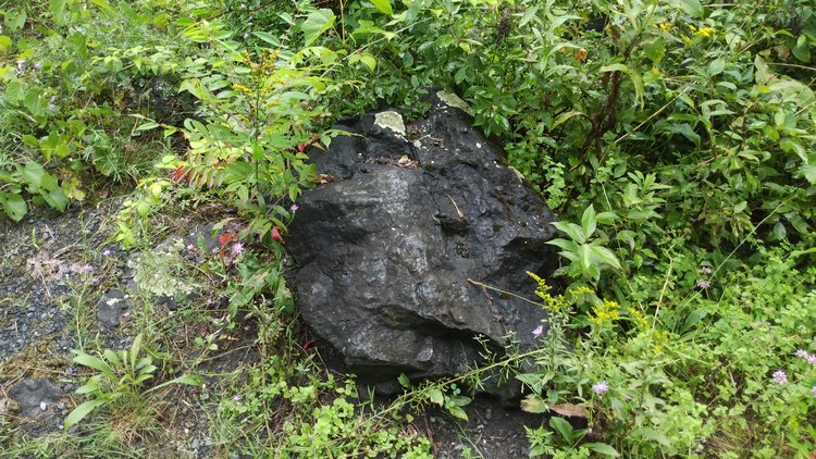
— Photo by Mike Nardacci
A boulder freshly broken from the bedrock of Stark’s Knob shows tiny pits called vesicles where bubbles escaped from the lava when it was still molten.
The rocky promontory known as “Stark’s Knob” rises a short distance north of the village of Schuylerville and when the leaves are off the trees its summit affords a panoramic view of the Hudson River.
Though its human history is but the wink of an eye compared to its geologic past, it played a pivotal role in the American Revolution. From its summit, the rebelling colonists observed British ships moving up and down the river.
Under the command of New Hampshire General John Stark, they moved cannon and other armaments to a flat area between the Knob and the Hudson River to prevent British troops from escaping after the battle of Saratoga.
But the Knob is also widely known as “the Schuylerville volcano,” and though it is not now erupting, the name conjures up visions of fiery fountains of lava and plumes of sulphurous smoke spilling out over the landscape.
But it was never a volcano and it did not originate in its present location. However — it is made of lava that has solidified in the form of bulbous mounds called “pillows,” and an unweathered chunk of its bedrock shows holes called “vesicles,” which are the remains of bubbles of escaping gasses.
Such “pillows” are forming today from fissures in the waters off the Big Island of Hawai’i as lava is ejected from fractures in the ocean floor. Curiously, some of the rocks in Stark’s Knob have been found to contain tiny fossils of shallow-water dwelling snails that lived in the Ordovician period, some 450 million years ago.
Clues to the past
Exposures of bedrock that have not vanished under the thick foliage that covers much of the Knob show the rounded, humpy “pillows” and in them and in their fossils lie the keys to understanding the Knob’s formation.
Some 450 million years ago during the Ordovician Period, the landmass that would someday be North America lay bordering a vast body of water known as the Iapetus Ocean, the name of which derives from Greek mythology.
Iapetus was a member of the race of giants called Titans and was known as the father of Atlas. The Iapetus long ago vanished as the plates of the Earth were beginning to assemble themselves into the supercontinent Pangaea, which millions of years later broke apart giving birth to a new ocean: the Atlantic.
In the mid-Ordovician Period — roughly 450 million years ago — the east coast of the United States corresponded roughly to today’s Hudson Valley and off that coast lay an arc of islands similar to those that make up Japan.
As the landmass that would become Africa closed in on the coast in a sliding, scraping motion known as a “transform fault,” those islands got caught up in the crunch and were plastered onto the coast. This action resulted in massive earthquakes and submarine fissures extruding lava — hence the formation of the lava making up Stark’s Knob.
As a result of the chaos, huge slabs of terrain were pushed westward, and the solidified mass of igneous rock that would be known as Stark’s Knob was pushed into its present position from the region that would become Vermont.
To use an obscure term that might be the $2,000 answer on Jeopardy — the solidified lava mass making up Stark’s Knob is allochthonous (al-LOCH-thon-ous), which the Dictionary of Geologic Terms defines as “Said of rocks or materials formed elsewhere than in their present place.”
New York state contains within its borders geologic phenomena that make the teaching of geology here the envy of those in many other states. New York has:
— The vast eroded sedimentary rock layers that constitute the Allegheny Plateau, containing fossils that are the keys to understanding Paleozoic life;
— Billion-year-old-plus rocks in Southeastern New York, Manhattan, and the Adirondacks, providing evidence of great upheavals in the Earth’s crust;
— Hundreds of square miles of karst terrain, laced with caves, underground streams, and springs;
— Dinosaur fossils in the rocks that border New Jersey; and
— Perhaps — perhaps — beneath the lofty and mysterious Adirondacks lies a “hot spot”: a plume reaching down into Earth’s mantle that might in some far future break the surface and produce a series of real volcanoes like those in Iceland.
And overlooking the Hudson just north of the village of Schuylerville lies a mass of solidified lava called Stark’s Knob, providing evidence of the titanic forces that drive Earth’s plates and quite literally move mountains.

— Photo by Mike Nardacci
A stretch of the Onesquethaw Creek near the intersection of Routes 85 and 443. Much of the year, the streambed appears dry and its water flows underground but wet weather and snowmelt can overwhelm the subterranean conduit and cause water to flow over the surface bedrock.
Rainy weather is the bane of most geologic field trips; perhaps the only weather worse is wet falling snow. A geology field trip in our part of the country often involves tramping through rough and sometimes wet terrain in search of locales in which our ubiquitous forests and ground cover do not obscure the bedrock; hence it may reveal fossils or minerals or tectonic structures contained therein and precipitation in any form can make for a genuinely miserable learning experience.
But the exceptions are field trips illustrating karst features. In times of snowmelt or heavy rainfall, a karst landscape reverberates as its sinkholes, grikes, springs, and disappearing streams gurgle with the sudden flow of turbulent waters.
At such times, it is well worth the effort to put on a rain slick and waterproof boots and head off into one of the many karst preserves of the Helderberg area and appreciate the dynamic features of these landscapes and of the hidden mysteries that lie beneath them.
However romantic the notion of cave geology may seem, the understanding of karst begins with a singularly mundane fact: Caves are in essence natural storm drains.
The term karst itself is derived from “Kras,” which is a plateau bordering on Slovenia and Italy. In the 19th Century, geologists recognized that its limestone bedrock laced with caverns and featuring sinkholes, underground rivers and streams, and springs represented a whole relatively unexplored branch of geologic studies.
The storm drains found in city streets, which are often miscalled “sewers,” transport runoff beneath the streets to the nearest river or stream without filtering it.
Likewise, in a karst region, rainfall and surface waters that are naturally mildly acidic can dissolve carbonate bedrock such as limestone or marble and produce subterranean streams that can flow for miles before they reach a place where they return to the surface in springs that may be either gravity-fed or artesian defying gravity. And in doing so they often carry volumes of sediments — both organic and non — and spew them back into the world.
Much of the Helderberg Plateau contains limestone surface bedrock. In the area of Thacher Park, two limestone layers named the Coeymans and the Manlius form a cliff 100 feet high in places featuring numerous small caves. A couple of hundred feet higher is a broad terrace formed on top of the Onondaga limestone cliff and traversed by the Beaverdam Road.
There are on the surface great numbers of sinkholes and fractures called grikes that can take water in wet times, and the caves in these limestone strata will then produce springs that burst from the cliffs under the pull of gravity and flow down into the valley below.
A similar gravity spring emerges from Barton Hill in Schoharie above Route 146. These springs frequently produce micro-environments conducive to the growth of mosses, ferns, algae, and watercress. At times — often seasonal — the waters emerging from gravity springs may be saturated with calcium carbonate in solution and will coat the rocks and organic materials in their paths with the mineral producing a spongy-looking rock known as tufa.
In dry times, water may be flowing just beneath the surface of dry-looking stream beds but will overflow to the surface during periods of snowmelt or high precipitation. One such example can be found in the upper reaches of the Onesquethaw Creek where it flows beneath a bridge near the intersection of Routes 443 and 85.
What for much of the time is a flat, arid limestone pavement featuring numerous grikes and other fractures becomes a series of plunge pools and rapids when excess precipitation renders the conduit just beneath the surface inefficient to carry the excess water.
Similar weather conditions can also produce temporary artesian springs in which water under pressure flows upward against gravity. The volume of water in a sizable cave passage overwhelms the ability of the cave to carry it, just as storm drains blast water to the surface when the volume of water exceeds the ability of the conduit to transport it.
An impressive example occurs several times each year near what is called the Gregory Entrance to Clarksville Cave. A fracture at the base of the surrounding cliff exhibits an impressive artesian spring: a cloudy pool with a surging hump of water in the middle as turbulent waters flow upward out of the cave and down an otherwise dry streambed and under Route 443.
This spring not only flows during times of snowmelt but may form and be gone within 24 hours in warmer weather following sudden heavy rainfall.
Disappearing streams
But perhaps the most impressive feature of a karst landscape during periods of exceptionally wet weather or spring thaw is the presence of disappearing streams. Pockmarking the terrain will be dozens — sometimes hundreds — of sinkholes that form when surface bedrock collapses into a void below.
At such times, flowing liquids will head toward the lowest topographic point and will produce streams that may flow for hundreds or thousands of feet over bedrock that does not dissolve as limestone does or tightly-packed glacial debris, both of which are common in the Helderberg area.
Suddenly reaching a sinkhole, a raging stream may vanish abruptly into the darkness below, leaving the surrounding landscape quiet except for bird calls. A well-known example is the sinkhole entrance to the Onesquethaw Cave system south of the village of Clarksville.
Sport cavers have long had great respect for Onesquethaw, which is capable of sudden flooding with rapidly-moving water following short periods of intense precipitation. The sinkhole entrance is in a very low area surrounded on its west side by steep shale hills, the runoff of which can cause huge volumes of water to cascade into the entrance. The flow resurges in a gravity spring a mile or so away off Route 32.
Geologists are known for braving dangerous topography and unpleasant weather conditions in pursuit of knowledge and mild, dry weather will ordinarily be most welcome on expeditions. But to truly appreciate a karst landscape it must be seen in weather conditions that would keep the less adventurous indoors.
For when the heavy rains fall or the snows melt, the landscape comes alive, with otherwise dry fractures in cliffs and other bedrock exposures suddenly blasting great volumes of sediment-laden water. These waters form rushing, meandering streams that seem to have come from nowhere; fields and forests full of gaping sinkholes that swallow those temporary streams then conduct the waters through dark chambers to often unknown destinations.
It is a landscape filled with mysterious sounds and sights that are well worth the temporary discomfort in experiencing them.
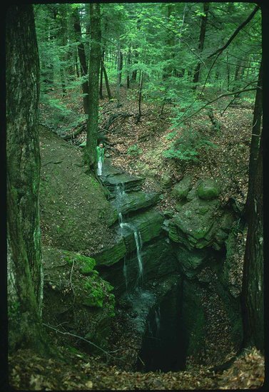
— Photo by Mike Nardacci
A gaping sinkhole in the McFails Cave Preserve swallows a stream that flows through McFails Cave and resurges over two miles away.
Most New York State caves are closed to visitors from Oct. 1 to May 1. For information about McFails Cave and other area caves, visit www.northeatserncaveconservancy.org.
Karst lands such as those in Albany and Schoharie counties in New York State and elsewhere on our planet have long been described as “hollowed ground.” When the surface bedrock is limestone — and less commonly marble, dolomite, or gypsum — rainwater or surface water that has become mildly acidic due to the absorption of carbon dioxide will infiltrate the bedrock under the influence of gravity; it will then dissolve the rock away, creating underground streams and rivers along with extensive cave systems.
In many regions, thick layers of limestone may be underlain by a type of rock such as shale or sandstone called an aquiclude that will not readily dissolve in acidic water, producing what geologists call base level; the water can then no longer dissolve downward but must find a way out of the rock and emerge as a spring, perhaps in a cliff such as those at Thacher Park or an artesian spring in which water under pressure flows upward against gravity.
Cave passages frequently develop along tectonic faults or angular cracks in the bedrock called joints, and so it is possible for several caverns with a common base level to join and form one extensive cave system.
In central Kentucky, for example, a number of lengthy individual caves on a plateau above the Green River have been found to connect to Mammoth Cave, producing a system now known to be over 400 miles in length. And similar geologic conditions in the plateau for thousands of surrounding acres hint that the cave’s passages may someday be found to extend for additional hundreds of miles.
The plateau stretching for miles above the city of Cobleskill can be seen as a somewhat smaller-scale version of the Mammoth Cave karst area: smaller-scale because its fossil-bearing Devonian-age Manlius and Coeymans limestone layers are much thinner than the 400-foot-thick limestone strata of central Kentucky and this fact limits the depth and number of the levels on which local caves can develop.
The forests and fields of the Cobleskill Plateau abound in known cave systems of various lengths, and yawning sinkholes — some 70 or more feet in depth — swallow rushing streams in warm months and belch clouds of icy condensation during times of severe cold, creating landscapes out of “The Lord of the Rings.”
Some of the plateau’s cave systems are known or suspected to connect with one another but dozens of sinkholes that are occluded by glacial boulders and soil allow only water to infiltrate and travel underground to previously known cave systems or still unknown destinations, effectively excluding human explorers.
Discovering McFails
One cave in particular, called McFails, the extent of which was unknown until the 1960s, has long excited both sport cavers and geologists. Its historic 110-foot vertical entrance lies in a stretch of mossy, shadowy acres of hardwoods and hemlocks filled with fissures, gaping sinkholes, and disappearing streams, all of which are known to feed into McFails.
Its name derives from the report that in the 1870s on a particularly hot and humid July day, a professor from a local academy by the name of T.C. McFail had descended on a rope ladder to the interior of the cave, a tight, wet, muddy fissure.
Whether he went any farther is unknown, but on his way back up the ladder — which he was climbing without a safety line — he passed suddenly from the 46-degree temperature of the cave into the sultry July heat and fainted, falling from the ladder and striking his head on a boulder. Despite his companions’ rescue efforts, he died, leaving his name as an ironic memory of his ill-fated exploration.
For nearly a 100 years, explorers entering the cave with proper technical equipment found only a few hundred feet of gloomy stream passageway, becoming too tight for human passage upstream and vanishing into a floor-to-ceiling pool downstream.
But in 1961 during a time of low precipitation, explorers from Cornell University found several inches of air above the pool and, though they had to get thoroughly soaked, they managed to push through the pool to find themselves in a high canyon with a rushing stream sometimes waist-deep that stretched for two miles and was filled with pristine formations.
And, as the canyon expanded into a series of chambers that rivalled in size those in nearby commercial Howe Caverns, another large passage — this one with a tubular cross-section and bearing another stream — entered from the northwest.
It was initially thought to extend for over a mile and terminate in a pile of huge breakdown boulders and slabs but explorers have pushed through it to find more of the main passage and side chambers that are still not fully explored.
Downstream the rushing creek passes through several “sumps” in which the water rises to the ceiling. These have been penetrated by divers to a point at which the passage becomes blocked to further human exploration.
And more recently, intrepid explorers have found an upper level to the canyon passage filled with stalactites, stalagmites, and exceedingly delicate, glittering formations called helictites, all of which form through the evaporation of mineral-saturated water. Most visitors are encouraged to avoid the area to avoid damaging them.
Owned today by the National Speleological Society, the cave and its surrounding karst features are managed by the Northeastern Cave Conservancy, and draw scientists and adventurers from all over the world.
Connections
Years ago, the historic entrance to McFails became unstable and collapsed. Today, entrance to the cave is made through either of two vertical drops requiring ropework.
One has the Tolkien-ish name of “Ackshack” and also requires an exhausting 100-foot crawl leading to the main cave. The other is a dizzying descent of a silo-like pit that frequently takes explorers through a gushing waterfall.
In any case, the preserve rules require visitors to wear wetsuits to avoid hypothermia on trips, which frequently last upward of 12 hours.
Hydrogeologists use a technique called “dye tracing” when water is flowing through a cave system with fissures that are too tight for human passage. A harmless dye is injected into the water and watch is kept on springs and streams in nearby caves to see where it emerges.
Years ago, it was determined that in times of normal flow the stream flowing through McFails Cave eventually finds its way to Doc Shauls Spring — an enormous artesian spring located in a crater-like depression more than two miles from the main entrance to McFails. From there it becomes tributary to the Cobleskill Creek.
However — in times of heavy snowmelt or excessive precipitation such as a tropical storm, the main passage of McFails becomes inefficient to carry all of the water rushing through the cave and the excess overflows into Howe Caverns, also more than two miles away from its insurgence points.
What makes the geologic situation even more interesting is the fact that a number of caves in the hills around Howe Caverns are connected to it — or were in the past. The remnant downstream section of Howe Caverns that was largely destroyed by quarrying operations is joined to Barytes Cave, which still exists.
Barytes in turn receives water from another undeveloped (or “wild”) cave called Benson’s, which is connected hydrologically to commercial Secret Caverns. These caves are all formed in the Manlius and Coeymans limestone layers and have a common base level.
Hence, estimates are that, if all of the known or suspected fragments could be joined, Schoharie County could boast of a cave system around 26 miles long. But then the Cobleskill Plateau is pockmarked with many karst features that could eventually be found to lead to new, separate cave systems or to be part of the vast complex.
In the shadow of looming Barrack Zourie Hill, one other such independent cave is known; it has been explored for a distance of two miles and has a stream that is also a tributary to the Cobleskill Creek.
The Cobleskill Plateau has long been known for its lush hardwood forests — enticing in all seasons, spectacular in the fall — its rocky cliffs and stony streams, its diverse animal and plant life, its fertile fields and orchards, and its long and colorful history from the days of its indigenous inhabitants through its Colonial period, down to the present.
But its fame as a geologic wonder has for a long time been much less appreciated. Under the plateau’s ancient, rolling hills, chemistry and gravity have been at work for millions of years, creating a vast and still not completely known network of long, meandering channels through the darkness that beckon the curious to explore.

Photo by Michael Nardacci
The farmhouse from which D.C. and Ada Robinson ran their commercial operation of Knox Cave stood on the Knox Cave Road until it was destroyed by fire around 1968
Most New York State caves are closed to visitors from Oct. 1 to May 1. For information about Knox Cave and other area caves, visit www.northeatserncaveconservancy.org.
Filled with darkness and featuring passages that twist and meander, caves by their very nature evoke legends and lore. Under one of the fields outside of the village of Knox, an eponymous cave has incited geologic interest and lore, and drawn explorers and scientists — and, from time to time, tourists — since the 19th Century.
Old histories of the Helderbergs make mention of its steep-sided entrance sinkhole though they do not record any exploration. Formed from the Devonian-age Manlius and Coeymans limestones, the cave consists of a series of parallel passageways on multiple levels formed along great vertical fractures in the rock called joints.
Knox is not among the longest or more challenging of the caves of the Northeast — it has around 4,000 feet of passage and only two sections require technical climbing (involving ropework). However, its notorious Gunbarrel passage (of which more later) and an arduous climb and crawlway that lead to the remote and once-beautiful Alabaster Room as well as the cave’s many legends have attracted sport cavers and scientists for many years.
Newspaper accounts dating to the 1920s report sometimes fanciful— or wishful — excursions into the cave, believed then to be miles in length. There were also apparently limited commercial excursions offered by members of the Truax family that owned the cave prior to the 1930s.
One can imagine hardy explorers venturing into the cave in the long-ago style made famous by Lester Howe in his own cave in the 1800s, scrambling over fallen boulders and through chilly pools, clad in canvas cloaks and bearing kerosene lanterns.
At some point in the 1930s, the Truax property was purchased by a retired couple from Long Island, Delevan C. Robinson — known as “D.C.” — and his wife, Ada. D.C. held a Ph.D. from Carnegie Tech and his wife had a master’s degree and had taught English on the secondary level.
He built an elaborate series of stairs that descended to the floor of the cave (over 110 feet underground) and he installed electric lighting in a section that was to be a tourist route. Wishing to keep his cave in a natural state, D.C. made walkways out of flat slabs of Manlius limestone from which lower levels of the cave were formed. As an additional draw, he built a large roller-skating rink that at times also functioned as a dance hall.
The problem that D.C. and others who attempted to commercialize Knox Cave encountered was the fact that, although the section of the cave easily accessible by the staircase featured several large, impressive chambers, tours lasted only about 45 minutes. This was far shorter than tours at nearby Howe Caverns, and those areas lacked an atmospheric gurgling stream such as Howe’s “River Styx” or any flowing water for that matter — a most curious fact for a New York State cave.
Some of the most interesting sections lay beyond the famous (infamous?) Gunbarrel. This is a 47-foot-long tubular passage, and its average diameter is only about 14 inches (that is not a typo!) through which paying customers could hardly be expected to squeeze.
In any event, in the early 1950s, D.C. also set out on an ambitious program of exploration in an attempt to find new and more accessible passages and to prove that Knox — known then to be only about 3,000 feet in length — was the longest cave in New York State.
Negley’s exploration
To that end, he enlisted a shadowy figure known as “Buck” Negley who was apparently a postal worker, spending his free time exploring Knox. Very short in stature and wiry, Negley could slither through cracks and crevices that many people would regard as impossible and he evidently did much of his exploring alone. (Serious violation of caving rules!)
Prior to his explorations, the cave was known to continue beyond the intimidating Gunbarrel to a roomy chamber that terminated in a pile of loose rocky debris. Pushing aside boulders and slabs (and probably placing his life in jeopardy), Negley was able to squeeze through and discovered a maze of lofty canyons and domes and a yawning pit.
He also navigated his way through a tight, tortuous passage known as the Crystal Crawlway for its pockets of calcite crystals and was able to climb down into what became known as the Alabaster Room. Once admired for its displays of milky, translucent stalactites and flowstone, the chamber today is a sad sight.
Incredible as it might seem, some of the visitors to this remote, hard-to-reach grotto have damaged or carried away many of its delicate formations. Oddly — though the room appeared to be the northern termination of Knox Cave, Negley claimed to have found a passage continuing beyond it, for which explorers searched for years.
But in the 1990s determined cavers dug out a clay-clogged passage in a secluded spot below the Alabaster Room and broke into a low, thousand-foot-long canyon carrying a stream, far below Knox’s once-commercial passages, solving a mystery of Knox Cave’s hydrology and perhaps vindicating the legendary Negley.
But another of Negley’s claims has yet to be confirmed. He insisted that he had wormed his way through a tight crawl east of the old commercial sections and found a room he described as “larger than a football field.”
Many scoffed at his claim — but the fact remains that the thick Coeymans and Manlius limestone strata that cover many square miles of woods and fields around the village of Knox are filled with sinkholes and fractures carrying surface water to unknown destinations and in which large caverns could develop.
It is not inconceivable that the black vastness of Negley’s Lost Room may yet await discovery for some intrepid — or very thin — explorers.
Frustration Crawl and New Skull Cave
Another more tangible mystery involves a tight tunnel known as “Frustration Crawl,” which has tantalized explorers for decades. Cavers can enter it on hands and knees but it soon turns into a flat-out belly crawl, its walls worn smooth from the abrasion of thousands of passing bodies.
But, after a hundred feet or so, human intrusion is halted by two thick curtains of flowstone that have descended from either side. Looking through a narrow space between them, cavers can see that the tunnel continues but they cannot.
However, the crawl is headed straight for another large cave system less than 1,000 feet away known as “New Skull Cave,” a tortuous, wet, muddy cave system known to have over five miles of challenging passageway. Off limits to sport cavers for years, New Skull has not been fully explored and may well continue for additional miles.
Were “Frustration Crawl” to connect Knox Cave to New Skull there would be the potential for one of the largest cave systems in the Northeast.
And why the designation as “New Skull?” A few hundred yards away from both the Knox and New Skull entrances there once was a wide, vertical sinkhole around which legends abound. A local tale says that in the mid-1800s, a farmer climbed down some 60 feet into it and entered a dripping, gloomy chamber, the floor of which was littered with human skeletons and the bones of large animals.
Some versions of the tale say the animals were long-horned steers, others that they were the remains of a giant Ice-Age ground sloth. In any case, horrified by his discovery, the farmer dumped huge boulders into the sinkhole and then filled it to the surface with dirt.
The upper 10 feet or so of the sinkhole was still visible in the 1960s and geologic features in its walls called fluting indicated that in the distant past it had been the insurgence point for large volumes of water. Today, the sinkhole reputed to lead to what has come to known as “Old Skull Cave” is no longer visible, having been completely filled with soil making it level with the surrounding fields, but its memory adds to the legends of the area, a lure as tantalizing as “Frustration Crawl.”
Access to Lemuria?
Doubtless the weirdest legend associated with Knox Cave derives from the book “I Remember Lemuria” by Richard Shaver published in 1948. In it, Shaver claims that far beneath the earth and accessible through certain caves is a whole separate and highly advanced civilization called Lemuria.
Its super-intelligent inhabitants do not want intruders from the surface and so they have bred a race of huge ape-like creatures armed with clubs to guard the access points and bash in the heads of any surface people who happen to wander in.
Shaver asserted that one of the caves offering access to Lemuria was Knox. Surely no comment on this story is needed; however — when I have taken groups of schoolkids into the cave in one of my Heldeberg Workshop summer caving classes, I have found that recounting the legend to them is a very effective way to keep any of them from wandering off.
The last attempt to commercialize Knox Cave occurred in the late 1950s, and tourist brochures as well as other ephemera of the cave from that period survive. When I was a boy, my parents took me on what turned out to be among the last commercial tours of Knox.
Even as a youth, I knew that the descent from the surface on that stairway was going to be intimidating to many tourists, especially the elderly — a far cry from the elevator that carried visitors effortlessly into Howe Caverns.
Brief though the tour was, the guide’s recounting of the cave’s history and lore was captivating. He spoke of the high narrow fracture called “Skeleton Passage” in which six human skeletons had allegedly been found along with a number of ancient torches — their whereabouts even then unknown.
He also fascinated visitors with tales of a mysterious tablet in an off-limits section of the cave which had inscribed upon it the hieroglyphic writings of the Nephites, who Mormons believe inhabited North America in the years before the Christian Era. (These subsequently proved to be natural solution channels carved into the Manlius limestone by dribbling acidic water.)
And the guide hinted at new discoveries which might stretch the cave’s length to 13 miles — an elusive goal, to say the least.
By the time the cave closed for commercial tours for the final time, D.C. Robinson had passed away, but the cave remained open for sport cavers and scientists. His wife, Ada, was known to all as a delightful woman who enthusiastically welcomed visitors, telling them perhaps wistfully that the cave had been “entered but not explored” for 13 miles.
Readers acquainted with “Aunt Arie” from the Foxfire books would have recognized her double in Mrs. Robinson with her print dress and apron, hair in a bun, and effervescent personality. Upon her death in 1964, the cave went through a period of confused ownership during which people came and went freely onto the property and into the cave.
Fires determined to have been arson destroyed first the abandoned skating rink and then the Robinson house.
Then, in 1976, a group of college students attempted to enter the cave in winter, crawling through an opening in a mass of ice that blocked the entrance. A huge chunk broke off, killing one student and seriously injuring another.
Another period of confusion followed but eventually Knox Cave was acquired by the Northeastern Cave Conservancy that now controls access. The nearby Knox Museum features a Knox Cave room, filled with photographs, memorabilia, and newspaper articles from the cave’s glory days, as well as plaster impressions of the “Nephite hieroglyphs.”
And so, from May 1 to Oc. 1, both sport cavers and scientists from all over the world hike the surrounding fields past the disintegrating ruins of the Knox Skating Rink and descend the gaping sinkhole to explore and study the cave’s geologic mysteries.
The vast entrance rooms still astound, the claustrophobic Gunbarrel still calls explorers to the chambers beyond, and reaching the long-unknown river passage still challenges cavers’ strength and endurance. And perhaps from some dark recess, the ghost of the mysterious Buck Negley urges the intrepid to push beyond one last tight squeeze that opens into an echoing chamber the size of a football field.

Among the many 19th-Century graffiti on the walls of the Clarksville Cave is the elegantly-carved “D.C. Gould August 12, 1864.”
Most New York State caves are closed to visitors from Oct. 1 to May 1. For information about Clarksville Cave and other area caves, visit www.northeatserncaveconservancy.org. I thank David Wallingford and his son Owen Tobias-Wallingford for their assistance in photographing the Clarksville Cave.
For generations, the Clarksville Cave system has drawn sport cavers and scientists alike.
Lying under a preserve owned and managed by the Northeastern Cave Conservancy, the cavern is half-an-hour drive from downtown Albany, just off Route 443. Histories of the village record visits to the cave in the mid-1800s, and graffiti from the Civil War Era and before are carved in sometimes elegant characters on its walls. (The precise moment at which graffiti go from being vandalism to history has never been determined, but carving on cave walls today is — to put it mildly — strongly discouraged!)
There are forms of vandalism other than carving, of course — spray-painting and littering of the passages with trash are sadly not unknown; some forms such as muddying formations by climbing on them may be unintentional but are no less damaging.
Regrettably, most of the Clarksville Cave’s delicate formations such as stalagmites, “soda-straw” stalactites, and the translucent “draperies” were broken off long ago, though in hard-to-reach areas of the cave some flowstone deposits and the unusual natural dams called “rimstone pools” have managed to escape vandalism.
In years’ past, visitors were invited to scratch their names into the walls; two of the most prominent were left by one “D.C. Gould” whose name was carved in neat letters on Aug. 12, 1864, and one “E. Brinley” whose name was incised in 1839 on a wall above a pool.
Yet, in spite of visits by untold thousands of people over the decades, the Clarksville Cave and its preserve remain iconic examples of geologic processes, and specifically of cave geology — known as speleology. Teachers of Earth science and geology in both secondary schools and colleges have used it as a resource for many years and, in the summertime, camps and environmental groups from all over the Northeast run field trips to the cave.
The preserve covers some 19.4 wooded acres, and within the forest are trails that lead not only to the cave’s multiple entrances but past classic examples of karst geology features: exposures of the bedrock called the Onondaga Limestone in which the cave has formed; mossy sinkholes and vertical shafts; and long solutionally-widened fractures in the bedrock called grikes.
In very wet weather, one of the cave entrances becomes an artesian spring and hourly thousands of gallons of turbulent water under pressure bubble upward against gravity and flow into the nearby Onesquethaw Creek.
The Onondaga limestone formed in a warm, shallow sea during what geologists call the Devonian Period, some 400 million years ago, when the landmass that would become North America lay much farther south than it is today and the Equator ran through the section that would become New York State.
It is a very clean limestone — almost pure calcium carbonate — with little or no clay or sand within it. This indicates that there were no high mountains near where it was forming that would have shed sediments into the water. It is densely packed with fossils such as crinoids (sea lilies), trilobites, clam-like brachiopods, and several species of coral.
The corals in particular are indicative of an environment of clear, relatively shallow, water. In some sections, the limestone is studded with nodules and shelves of the silicate rock called chert — or flint — which has precipitated there through processes still not completely understood.
The ages of caves are often difficult to determine. Except for lava caves such as those in Hawaii that form in real time as lava flows cool, the age of a cave has nothing to do with the age of the bedrock from which it has formed.
But one of the obvious features of the Clarksville Cave system is that it contains enormous deposits of rounded pebbles and cobbles in a clay matrix: remnants of debris left when glaciers retreated at the end of the last ice age some 12,000 years ago and their meltwaters roared through the cave carrying massive quantities of sediments.
These deposits can be found in even the loftiest parts of the cave. They indicate that the cave passages were there before deglaciation and for a time were choked with tightly-packed sediment; subsequently post-glacial streams found routes into the cave through the limestone bedrock layers that border Stovepipe Road west of the hamlet and elsewhere and began to flush out the sediments.
However, clues to a cave’s age are the features known as speleothems: stalactites, stalagmites, and flowstone that form from mineral-saturated water seeping into the cave. The old rule-of-thumb that every cubic inch of such features requires 100 years to grow has been shown to vary tremendously from one cave to another, but a massive flowstone feature such as that in the accompanying photo (Figure 3) undoubtedly required tens of thousands if not hundreds of thousands of years to form.
To put it simply — Clarksville Cave is old!
It has formed along a tectonic fault that shows itself in many places in the cave passages and at the surface where scratches called slickensides and folds in the bedrock appear. One particularly prominent display is in the bed of the Onesquethaw Creek just a few yards east of the stone bridge on Plank Road.
Within the cave, the ceilings of many passages show a slight tilt from west to east as a result of the fault movement. This tilt has allowed great quantities of mineral-saturated water to enter the cave over millennia, with the result that masses of flowstone accumulated on the western sides of the cave passages — much of it now damaged — and in some places the waters have acted as a natural cement, turning large piles of glacial debris into the sedimentary rock called conglomerate.
The cave was frequently visited in the 1800s — at least for a time its owner offered guided tours by lantern light and the cave was written up in Harper’s Weekly.
Until the early 1960s, the system was regarded as two separate caves, with one entrance in the village close to Route 443 called “Gregory’s Cave” after its then-owner. It consists of a series of lofty chambers connected by a wide tunnel carrying a meandering stream and terminating after around 450 feet in a pool rising nearly to the ceiling — a feature which cave explorers call a “sump.”
A longer section entered through a sinkhole in the woods bordering the hamlet trends north and was known as “Ward’s Cave.” Around 1,200 feet long, this section resembles a subway tunnel through which flows the upper stretch of the same gurgling stream, rising in a deep artesian pool near the north end, known rather grandly as The Lake.
But for years after the 1948 publication of “Underground Empire” by Clay Perry, which dealt with the caves of New York State, explorers were intrigued by Perry’s statement that the two caves were connected by what he described as a half-mile long tunnel lined with calcite crystals.
Then, during the summer of 1962, an extended drought hit New York State and the water level in the sump in the Gregory section dropped almost three feet. Following the cave explorer’s directive — “Follow the water!” — within a couple of days of each other, one group of explorers from Albany and another from the Boston area waded through the sump and found that the cave continued in the direction of the Ward section.
To this day, no one is certain which group was first; cavers are notoriously — some would say obsessively — reluctant to give details about their discoveries. But within weeks the word was out that a major breakthrough had been made in Clarksville and that the two caves were now connected.
To everyone’s amazement, in lamplight the then-pristine formations in the connection section did indeed sparkle in the form of calcite crystals that seemed to cover every surface. This discovery obviously raised the intriguing possibility that some intrepid explorers in the distant past had also made the connection yet somehow left no trace of their passage.
Alas, most of the crystalline surfaces are today obscured under a coating of mud left by the boots and clothing of more recent visitors.
Yet even so, the connection is not without its wonders: mysterious side passages that sometimes loop back upon themselves; the artificial-looking rimstone pools; bedrock twisted and distorted under pressure of the fault movements; great slabs of rock coated with slickensides; a high, funereal chamber where lengthy roots from trees in the forest above hang like black veils in the gloom; a 40-foot wide waterfall whose currents of crystal-clear water send echoes throughout this section of the cave, sounding eerily like energetic conversation; and on almost every exposed surface the marvelous, mysterious Devonian fossils.
One can easily understand why the Clarksville Cave is considered a veritable textbook of geologic phenomena.
Today, being under the protection of the Northeastern Cave Conservancy and its appointed cave managers and lying so close to so many colleges and primary and secondary schools, the Clarksville Cave will continue to attract sport cavers, adventurers, and students for generations to come.
And, while walking or crawling through its inky-black recesses, one can only wonder what secrets the cave yet holds in the unknown passages from which its waters come, and the mysterious conduits into which they flow.