Yes, Berne has a historical district (and yes, it’s enforceable)
— Map from the town of Berne
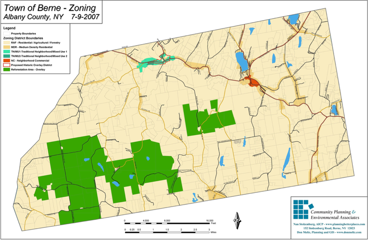
This is Berne’s official zoning map. Although the legend suggests that the town’s historic district, outlined in red, is only “proposed,” it is an enforceable zoning district.
BERNE — After Ken Guarino bought his house on Helderberg Trail, just across from the town hall, he was surprised to learn in the middle of the process that it fell within the town’s historic district.
“Homeowners who purchased houses before and after me, as well as their real-estate agents, also did not know this,” Guarino said of the zoning.
Albany County Legislator Chris Smith, who worked on the house, told The Enterprise that he, too, hadn’t known that it was subject to historic-district regulations until halfway through, when he was told he had to replace $8,000 worth of windows.
“I don’t know if there is a historic district,” he said this week, as The Enterprise was investigating. “I hear there is, and then I hear there’s not.”
Smith said he would never buy a house in that area again, since it seemed that some people were held to the standard while others weren’t. Some of this he chalked up to a period where the town was moving rapidly through a series of code-enforcement and inspection officials.
“We were just flying through building department people,” he said, adding that he couldn’t remember with certainty who it was that had told him to replace the windows.
The only clear evidence of where the district is located is the town’s official zoning map — which would be obvious and definitive enough, except that it refers to the district in its legend as the “proposed historic overlay district,” suggesting that it’s not actually in place.
“Homeowners and real-estate agents are not going to scan years of minutes to determine town laws,” Guarino said. “They will go to the eCode site [where the town’s laws are published] or town site to review local laws and zoning restrictions. If there is no map available showing the detailed boundaries of a historical district, can the town enforce historical district laws?”
Unfortunately for anyone who has felt blindsided by the regulations, the answer is yes.
The district itself dates back to 1974, when the town established its original zoning ordinance, around the time all of New York state was working on original zoning laws.
The same issue of the Enterprise where Berne published a copy of its first zoning law covers the establishment of Albany County’s first agricultural district and reports on a meeting of Knox farmers who had gathered to study that town’s first zoning proposal.
However, it wasn’t until 30 years later that the town worked with planner Nan Stolzenburg, of Community Planning and Environmental Associates, to actually map the boundaries so that they reflected the district described in the law.
“The Town has had a historic zoning district in their zoning for years,” Soltzenburg told The Enterprise in an email this week. “When I started planning work there many many years ago, the zoning had already established the district and included development standards, but had never mapped the boundaries.
“Part of the work I did for them was to map this district. So it is now treated like any other zoning district and the Town can enforce its own zoning.”
The town board voted to update its zoning map in 2005 with the historic-district boundaries at the same time they voted to establish two new districts — the Traditional Neighborhood / Mixed-Use Districts 1 and 2, which together cover much of the same area as the historic district.
In 2007, the board voted to officially adopt the map reflecting the changes the board made to its zoning laws in 2005, plus any alterations that may have been made in the two intervening years.
Why the legend refers to the historic district as proposed is still unclear. Stolzenburg could not explain that language, but acknowledged that it “may be what led to the confusion” over the district’s existence for some people.
Adding more confusion is that, in addition to this official zoning map found on the town’s code repository, eCode, the town has published a second map on its own website, under the comprehensive plan page, that includes both the TN/MUs but not the historic district.
Both the origin and inclusion of this map on the town site is unclear, given the turnover the town has seen in the many years that this issue spans, but the fact remains that the map showing the historic district outline is the town’s official and enforceable zoning map.
The New York State Department of State deferred all questions about enforcement in light of the confusion to the town’s building department.
The town, for its part, very much stands by the district as established, per a letter that former Deputy Supervisor Anita Clayton wrote to Guarino last year after he had inquired about it.
“Despite the map reading ‘Proposed’ Historic District it was in fact Adopted in 2005 [sic] and does stand today,” Clayton wrote.