Geologic puzzles in Ravena

The Enterprise — Mike Nardacci
An outcrop of Onondaga limestone can be found along Route 102 with a small shelter at its base. It is apparently an erosional remnant of the layers that covered this area millions of years ago.
The Enterprise — Mike Nardacci
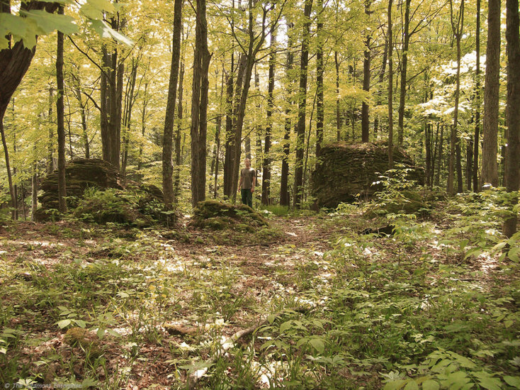
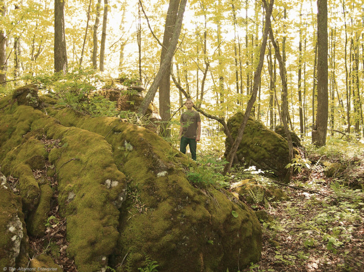
A section of woods in Joralemon Park shows enormous isolated blocks of limestone randomly scattered. (A Hudson Valley Community College student appears in these photos for scale.)
The Enterprise — Mike Nardacci
These blocks are tilted in many directions, indicating they have been displaced from their original horizontal positions.
The Enterprise — Mike Nardacci
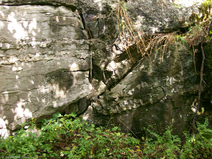
A textbook fault in a small limestone bluff in Joralemon Park shows two parallel layers of the rock known as “chert” within the limestone have been displaced by the fault’s movement. The layers on the left have been moved upward while those on the right have moved downward.
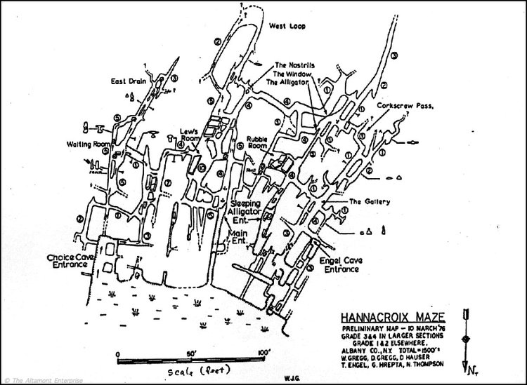
— Map courtesy of the National Speleological Society
Hannacroix Maze, a maze cave in Joralemon Park, near Ravena, was formed by chemical weathering.
An old joke among people whose life interest is rocks is that, if you ask 10 geologists the reasons for an unexplained geologic phenomenon, you will get 10 different answers. Some of the answers will be stated with qualifications while some will be issued with Biblical certainty, and, as some of the explanations will be mutually exclusive, they may set off lively — even bitter — debates.
The wooded areas along Route 102 in Ravena — and in particular, Joralemon Park — have been known to geologists for decades as places of considerable geologic interest.
Among the area’s features are stretches of bare bedrock showing scratches from the passage of glaciers thousands of years ago; a series of easily visible faults produced by very ancient earthquakes; remnants of ancient caves; complex systems of active caves that have yet to be fully explored; sinkholes and karst ponds into which surface waters disappear or from which they emerge; isolated outcrops of 400-million-year-old Paleozoic bedrock, remainders of once-extensive layers deposited in pre-historic oceans; and massive boulders, some scattered randomly through the woods and offering no immediate clues to the reason for their presence.
Rocks, of course, do not simply appear out of nowhere. In mountainous areas, rocky sediments of all sizes weather and erode out of the exposed bedrock. In wide, flat areas far from mountains — such as large stretches of the Hudson Valley and much of the Northeast — rocks must be carried and deposited by streams or glaciers.
The rocks that turn up in farmers’ fields with the maddening frequency of weeds were deposited there thousands of years ago either directly by glacial ice or by the streams that poured from them when they began to melt.
In his great poem, “Mending Wall,” Robert Frost described such rocks found in the stone walls of New England: “And some are loaves and some so nearly balls/ We have to use a spell to make them balance:/ ‘Stay where you are until our backs are turned!’”
The important facts are that erosion by glaciers tends to take the sharp edge off of transported rocks while running water tends to make them more or less rounded; and that glacially deposited rocks are usually “erratics”: specimens of rock types that are not found locally and have often been brought from hundreds of miles away.
And so the Helderberg landscape is dotted with purple sandstone cobbles from Potsdam, rounded fragments of granite and anorthosite from New York’s High Peaks, and chunks of garnet-bearing metamorphic rock from the North Creek area. These sediments are referred to as “glacial drift” deposits and they cover much of the landscape of the Northeast.
Mystery outcrops
And herein lie the puzzles of the Ravena rocks.
A mile or two north of the park, on Route 102, is a massive outcrop of rock that stands alone, looking to be more appropriate to some desert landscape of the Southwest than New York State. It is made of the 400-million-year-old Onondaga limestone, as is much of the surface rock of Joralemon Park, and local lore has it that Native American Indian artifacts were found long ago in the shelter on its north side.
Certainly, it would be an inviting place to spend a rainy night for a hunting party. Its layers lie horizontally on the surrounding terrain — it does not show the disturbance geologists call “displacement.” Moreover, its edges are rather jagged, not blunted; hence, it is unlikely to have been deposited there by a glacier.
While extensive excavation around it would be necessary to make a certain judgment, it is very likely an erosional remnant, a lone remainder of the thick layers of Onondaga limestone that millions of years ago covered the Joralemon area. There are other, smaller such outcrops scattered through the forest.
The massive outcrop is, in other words, likely to be “in place“ as geologists would say. The eponymously-named Joralemon Cave — its entrance yawns on the east side of Route 102 — is located in just such an erosional remnant, a segment of a long-vanished cave system.
The heavily-shaded interior of Joralemon Park contains numerous seeps and springs and swampy areas scattered beneath a forest of tall hardwood trees that trap much of the moisture. This creates an environment evocative of a rain forest, highly conducive to the growth of moisture-loving plants, which are remarkably diverse and prolific in the park.
A few hundred feet into the woods north of the bluff containing Joralemon Cave is an impressive high mound of giant boulders of Onondaga limestone. Its provenance is not so easily determined.
The boulders are wonderful to walk among in early spring and late fall — those times of the year when little growth is occurring, for they contain a collection of various types of mosses and ferns growing on and between them that would be damaged by foot traffic and that would delight any pteridologist or cryptogamic botanist (and yes- — I had to look up the terms!).
They are a spectacular place for children to play hide-and-seek or to imagine the boulders as the ramparts of a castle. Often 10 feet or more on a side, they contain between them innumerable overhangs and shady fractures and passageways, leading upwards or down, hiding places for toads and newts and the occasional black racer — a harmless but intimidating snake that in the Joralemon area can reach a length of six feet.
What is problematic about the boulders is that they are not horizontal to the surrounding bedrock. They are tilted or even upended as if piled there by a deranged giant.
Moreover, the tilts — what geologists call the “dip” of the rocks — are not uniform: One tilts north, its neighbor tilts south, and surrounding boulders may dip toward all the cardinal and ordinal directions on the compass.
Normally, in such a confusing display, a geologist would look on the rocks for “slickensides” — lines gouged into the bedrock when the two sides of a fault move, much as two cars scraping one another in opposite directions would scratch the surfaces. There are a number of such faults visible in exposed bedrock in Joralemon Park, evidence of one or more of the massive, earthquake-producing plate-tectonic events known as “orogenies” that have affected this part of the continent over the last 400 million years.
One of them is worthy of a geology textbook. But, as the boulders are covered in mosses, ferns, algae and liverworts, the slickensides — if they are there — are either obscured by the luxuriant plant growth or have been weathered away by it.
The point is that faults move massive amounts of bedrock during an earthquake. They may displace the rocks on one side of a fault upward relative to the opposite side or they may move them down; they may slide them sideways relative to each other or one side may dive under the other; and they are capable of distorting the rock structure in ways that have geologists scratching their heads trying to figure out just what Mother Nature was up to.
Amazing maze caves
A glance at a map of the active cave system in Joralemon Park may offer a clue.
Known as Hannacroix Maze (its waters feed the Hannacroix Creek), the cave is a true maze. If the prospect of getting lost within its labyrinth were not sufficient to intimidate explorers, the fact that it drains an adjacent beaver pond and is filled with fetid water inhabited by an assortment of creepy crawlers and swimmers usually does the trick.
Maze caves form in places where carbonate bedrock such as limestone or marble is heavily laced with the fractures known to geologists as “joints.” When waters containing mild natural acids — carbonic acid is common — enter the cave in times of flooding, the acidic solution is injected under pressure into every available crack and crevice, and voila! Chemical weathering forms a cave with a maze pattern.
One can easily notice, however, that between the cave passages are angular areas of bedrock. Should erosion eventually remove the roof of the cave, the result would be a rocky ramble such as the famous “Devil’s Den” in the Gettysburg Battlefield.
The “Devil’s Den” is made of igneous rock, not limestone, and the outcrops do not show displacement, so the situations are not exactly parallel. Still, both the cave and the battlefield outcrop represent bedrock in which erosion has occurred on the numerous joints the rock contains, resulting in a maze.
And so it would appear that the great rock pile in Joralemon Park must have resulted from the pre-historic movement of a series of faults running through a massive outcrop of limestone, eventually causing the weathered blocks to be left scattered helter-skelter in the forest.
Or so it would seem.
And yet — there are geologists who will defend the notion that the rocks are indeed glacially deposited — and that the reason that they consist of the same bedrock as the rest of the park and show little of the blunting that would result from glacial erosion is that they just have not been carried very far from their point of origin.
Perhaps it does not matter.
For the fact is that, within the wilds of Joralemon Park, lies a misty forest where water springs mysteriously from the bedrock; where marvelously diverse, unusual plants cover, it seems, every square inch of ground; and where Mother Nature shows her sleight-of-hand in strange geologic phenomena, through the agents of tectonics and weathering and erosion, over time beyond human comprehension.